
| Memorials | : | 0 |
| Location | : | Knapwell, South Cambridgeshire District, England |
| Coordinate | : | 52.2491000, -0.0447000 |
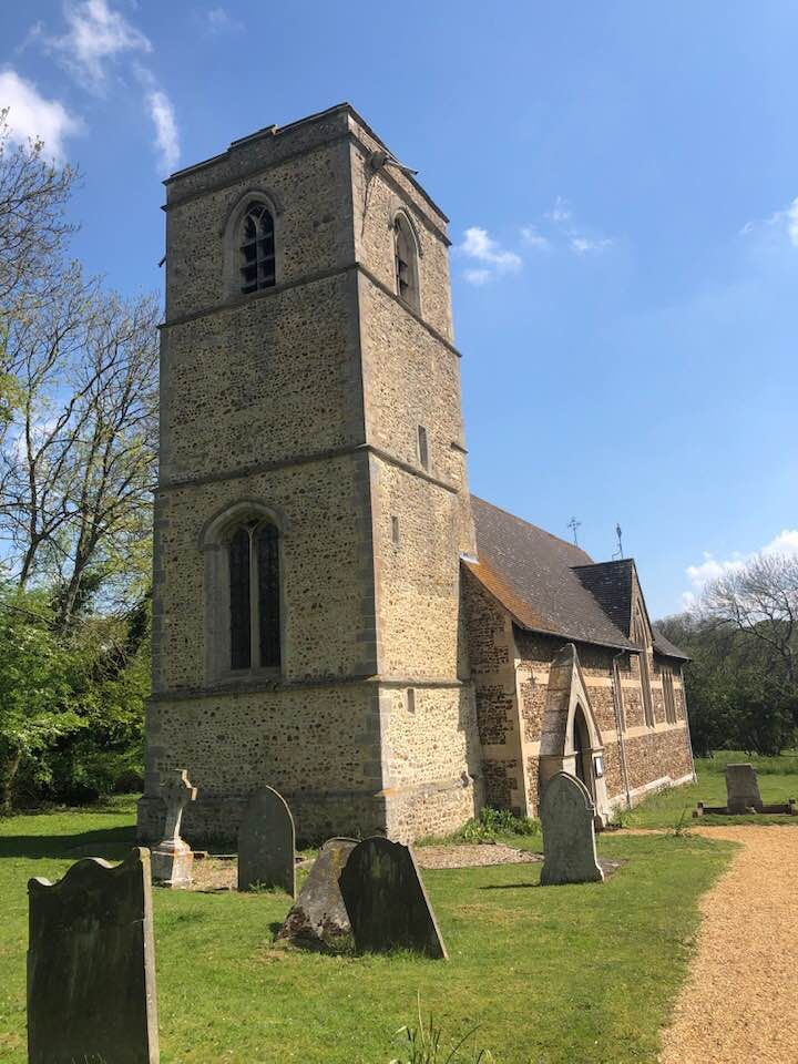
| Description | : | A church has been on this site since the 12th century but the present church was built in the 16th and 18th centuries. The main body of All Saints is typical of Victorian ecclesiastical architecture especially in the use of black and red brickwork. It has a beautiful, compact and well-proportioned design in the chancel’s elegant ‘Ship’s keel’ beamed ceiling and curved apse. Now it serves the village of Knapwell and has a small grave with about 60 graves |
frequently asked questions (FAQ):
-
Where is Church of All Saints?
Church of All Saints is located at Knapwell, Cambridge Knapwell, South Cambridgeshire District ,Cambridgeshire , CB23 4NWEngland.
-
Church of All Saints cemetery's updated grave count on graveviews.com?
0 memorials
-
Where are the coordinates of the Church of All Saints?
Latitude: 52.2491000
Longitude: -0.0447000
Nearby Cemetories:
1. Elsworth Particular Baptist Chapelyard
Elsworth, South Cambridgeshire District, England
Coordinate: 52.2559800, -0.0686500
2. St. Peter's Churchyard
Boxworth, South Cambridgeshire District, England
Coordinate: 52.2620660, -0.0257910
3. All Saints Churchyard
Lolworth, South Cambridgeshire District, England
Coordinate: 52.2583600, 0.0020200
4. St Mary Churchyard
Conington, South Cambridgeshire District, England
Coordinate: 52.2768320, -0.0665850
5. Cambourne Burial Ground
Cambourne, South Cambridgeshire District, England
Coordinate: 52.2179190, -0.0682910
6. St Peter and St Paul Churchyard
Dry Drayton, South Cambridgeshire District, England
Coordinate: 52.2389600, 0.0197800
7. St Mary Churchyard
Fen Drayton, South Cambridgeshire District, England
Coordinate: 52.2948320, -0.0369930
8. St Mary Churchyard
Hardwick, South Cambridgeshire District, England
Coordinate: 52.2085500, 0.0069700
9. Caxton Baptist Chapel
Caxton, South Cambridgeshire District, England
Coordinate: 52.2064820, -0.0926220
10. St. Peter and St. Paul Churchyard
Fenstanton, Huntingdonshire District, England
Coordinate: 52.3009610, -0.0653900
11. Fenstanton Cemetery
Fenstanton, Huntingdonshire District, England
Coordinate: 52.3013000, -0.0650700
12. Huntingdon Road Cemetery
Cambridge, City of Cambridge, England
Coordinate: 52.2435900, 0.0462900
13. Church of St Andrew
Caxton, South Cambridgeshire District, England
Coordinate: 52.2031956, -0.0986441
14. Cambridge City Crematorium
Girton, South Cambridgeshire District, England
Coordinate: 52.2443620, 0.0497920
15. St Mary Magdalene Churchyard
Madingley, South Cambridgeshire District, England
Coordinate: 52.2235570, 0.0408820
16. St. Helena and St. Mary Churchyard
Bourn, South Cambridgeshire District, England
Coordinate: 52.1896940, -0.0639950
17. St John the Baptist Churchyard
Papworth St Agnes, South Cambridgeshire District, England
Coordinate: 52.2641300, -0.1414700
18. St. Andrew's Churchyard
Swavesey, South Cambridgeshire District, England
Coordinate: 52.3050100, -0.0025700
19. St. Michael and All Angels
Caldecote, Huntingdonshire District, England
Coordinate: 52.1879970, -0.0308670
20. Longstanton Cemetery
Longstanton, South Cambridgeshire District, England
Coordinate: 52.2800010, 0.0433180
21. All Saints Churchyard
Longstanton, South Cambridgeshire District, England
Coordinate: 52.2780700, 0.0485100
22. St. Michael's Churchyard
Longstanton, South Cambridgeshire District, England
Coordinate: 52.2729100, 0.0544700
23. St Pandionia and St John the Baptist Churchyard
Eltisley, South Cambridgeshire District, England
Coordinate: 52.2205960, -0.1445670
24. All Saints & St Andrew Churchyard
Kingston, South Cambridgeshire District, England
Coordinate: 52.1806200, -0.0326300