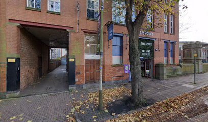
| Memorials | : | 0 |
| Location | : | Leicester, Leicester Unitary Authority, England |
| Coordinate | : | 52.6308229, -1.1417201 |
| Description | : | Commonly know as St. Mary of the New Work, the Church of the Annunciation of St. Mary was begun in 1330, by Henry, 1st Duke of Lancaster, to act as a mausoleum for the Dukes of Lancaster. It had its own college of clergy, consisted of twelve canons, thirteen vicars and six choristers, supported one hundred poor persons to administer to the church and the patients in the hospital. The clergy were to live in dwellings located around the church whilst the poor were to dwell in cubicles in the hospital. Destroyed in 1539. The Hawthorn building in Leicester, was... Read More |
frequently asked questions (FAQ):
-
Where is Church of the Annunciation of St. Mary?
Church of the Annunciation of St. Mary is located at Leicester, Leicester Unitary Authority ,Leicestershire ,England.
-
Church of the Annunciation of St. Mary cemetery's updated grave count on graveviews.com?
0 memorials
-
Where are the coordinates of the Church of the Annunciation of St. Mary?
Latitude: 52.6308229
Longitude: -1.1417201
Nearby Cemetories:
1. St. Mary de Castro Churchyard
Leicester, Leicester Unitary Authority, England
Coordinate: 52.6322610, -1.1404000
2. St. Nicholas Church
Leicester, Leicester Unitary Authority, England
Coordinate: 52.6351400, -1.1408940
3. Leicester Cathedral
Leicester, Leicester Unitary Authority, England
Coordinate: 52.6347430, -1.1370210
4. All Saints Church
Leicester, Leicester Unitary Authority, England
Coordinate: 52.6381940, -1.1403170
5. Great Meeting Unitarian Chapel
Leicester, Leicester Unitary Authority, England
Coordinate: 52.6379400, -1.1360390
6. St George's Church
Leicester, Leicester Unitary Authority, England
Coordinate: 52.6344300, -1.1267420
7. St Margaret Churchyard
Leicester, Leicester Unitary Authority, England
Coordinate: 52.6403430, -1.1363440
8. Welford Road Cemetery
Leicester, Leicester Unitary Authority, England
Coordinate: 52.6200104, -1.1295080
9. St Peter's Church (Defunct)
Leicester, Leicester Unitary Authority, England
Coordinate: 52.6300260, -1.1164980
10. Leicester Abbey
Leicester, Leicester Unitary Authority, England
Coordinate: 52.6489600, -1.1369470
11. St. john the Baptist
Leicester, Leicester Unitary Authority, England
Coordinate: 52.6181730, -1.1118790
12. St Peter's Churchyard
Braunstone, Blaby District, England
Coordinate: 52.6208940, -1.1812900
13. Gilroes Cemetery and Crematorium
Leicester, Leicester Unitary Authority, England
Coordinate: 52.6514359, -1.1721700
14. St Andrew Churchyard
Aylestone, Leicester Unitary Authority, England
Coordinate: 52.6038420, -1.1568900
15. Saint Mary Magdalene Churchyard
Knighton, Leicester Unitary Authority, England
Coordinate: 52.6054170, -1.1163730
16. St. Peter's Churchyard
Belgrave, Leicester Unitary Authority, England
Coordinate: 52.6594208, -1.1255690
17. Belgrave Cemetery
Belgrave, Leicester Unitary Authority, England
Coordinate: 52.6653570, -1.1311220
18. Saffron Hill Cemetery
Leicester, Leicester Unitary Authority, England
Coordinate: 52.5934120, -1.1310010
19. St. Denys' Churchyard
Evington, Leicester Unitary Authority, England
Coordinate: 52.6193210, -1.0743860
20. St Peter's Church
Glenfield, Blaby District, England
Coordinate: 52.6490490, -1.2063180
21. St. Mary's Churchyard
Humberstone, Leicester Unitary Authority, England
Coordinate: 52.6479200, -1.0760100
22. St James the Great Churchyard
Birstall, Charnwood Borough, England
Coordinate: 52.6741150, -1.1189210
23. Greengate Lane Cemetery
Birstall, Charnwood Borough, England
Coordinate: 52.6800110, -1.1346940
24. Anstey Cemetery
Anstey, Charnwood Borough, England
Coordinate: 52.6680480, -1.1955570

