
| Memorials | : | 233 |
| Location | : | Braunstone, Blaby District, England |
| Coordinate | : | 52.6208940, -1.1812900 |
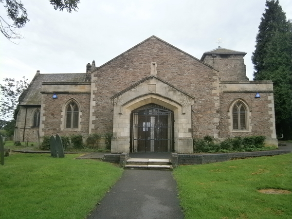
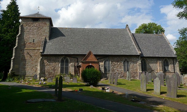
| Description | : | The church is the oldest building in the town of Braunstone, dating back to Norman times. It was first recorded in 1168. Visible graves in the churchyard range from the 17th century, up to the present day. |
frequently asked questions (FAQ):
-
Where is St Peter's Churchyard?
St Peter's Churchyard is located at Woodshawe Rise Braunstone, Blaby District ,Leicestershire , LE3 1RHEngland.
-
St Peter's Churchyard cemetery's updated grave count on graveviews.com?
232 memorials
-
Where are the coordinates of the St Peter's Churchyard?
Latitude: 52.6208940
Longitude: -1.1812900
Nearby Cemetories:
1. St Andrew Churchyard
Aylestone, Leicester Unitary Authority, England
Coordinate: 52.6038420, -1.1568900
2. Church of the Annunciation of St. Mary
Leicester, Leicester Unitary Authority, England
Coordinate: 52.6308229, -1.1417201
3. St. Mary de Castro Churchyard
Leicester, Leicester Unitary Authority, England
Coordinate: 52.6322610, -1.1404000
4. St. Nicholas Church
Leicester, Leicester Unitary Authority, England
Coordinate: 52.6351400, -1.1408940
5. Leicester Cathedral
Leicester, Leicester Unitary Authority, England
Coordinate: 52.6347430, -1.1370210
6. All Saints Church
Leicester, Leicester Unitary Authority, England
Coordinate: 52.6381940, -1.1403170
7. Gilroes Cemetery and Crematorium
Leicester, Leicester Unitary Authority, England
Coordinate: 52.6514359, -1.1721700
8. Welford Road Cemetery
Leicester, Leicester Unitary Authority, England
Coordinate: 52.6200104, -1.1295080
9. St Peter's Church
Glenfield, Blaby District, England
Coordinate: 52.6490490, -1.2063180
10. Great Meeting Unitarian Chapel
Leicester, Leicester Unitary Authority, England
Coordinate: 52.6379400, -1.1360390
11. St Margaret Churchyard
Leicester, Leicester Unitary Authority, England
Coordinate: 52.6403430, -1.1363440
12. Enderby Dissenters' Cemetery
Enderby, Blaby District, England
Coordinate: 52.5904190, -1.2049480
13. Enderby New Cemetery
Enderby, Blaby District, England
Coordinate: 52.5902330, -1.2048290
14. St John the Baptist Churchyard
Enderby, Blaby District, England
Coordinate: 52.5901570, -1.2077130
15. St Bartholomew Churchyard
Kirby Muxloe, Blaby District, England
Coordinate: 52.6371750, -1.2320940
16. St George's Church
Leicester, Leicester Unitary Authority, England
Coordinate: 52.6344300, -1.1267420
17. Kirby Muxloe Cemetery
Kirby Muxloe, Blaby District, England
Coordinate: 52.6373740, -1.2337780
18. Leicester Abbey
Leicester, Leicester Unitary Authority, England
Coordinate: 52.6489600, -1.1369470
19. St Peter's Church (Defunct)
Leicester, Leicester Unitary Authority, England
Coordinate: 52.6300260, -1.1164980
20. Saffron Hill Cemetery
Leicester, Leicester Unitary Authority, England
Coordinate: 52.5934120, -1.1310010
21. St. john the Baptist
Leicester, Leicester Unitary Authority, England
Coordinate: 52.6181730, -1.1118790
22. Saint Mary Magdalene Churchyard
Knighton, Leicester Unitary Authority, England
Coordinate: 52.6054170, -1.1163730
23. Groby Village Cemetery
Groby, Hinckley and Bosworth Borough, England
Coordinate: 52.6542170, -1.2348310
24. St Philip and St James Churchyard
Ratby, Hinckley and Bosworth Borough, England
Coordinate: 52.6489370, -1.2433610