
| Memorials | : | 0 |
| Location | : | Jeffersonville, Clark County, USA |
| Coordinate | : | 38.2818400, -85.7206700 |
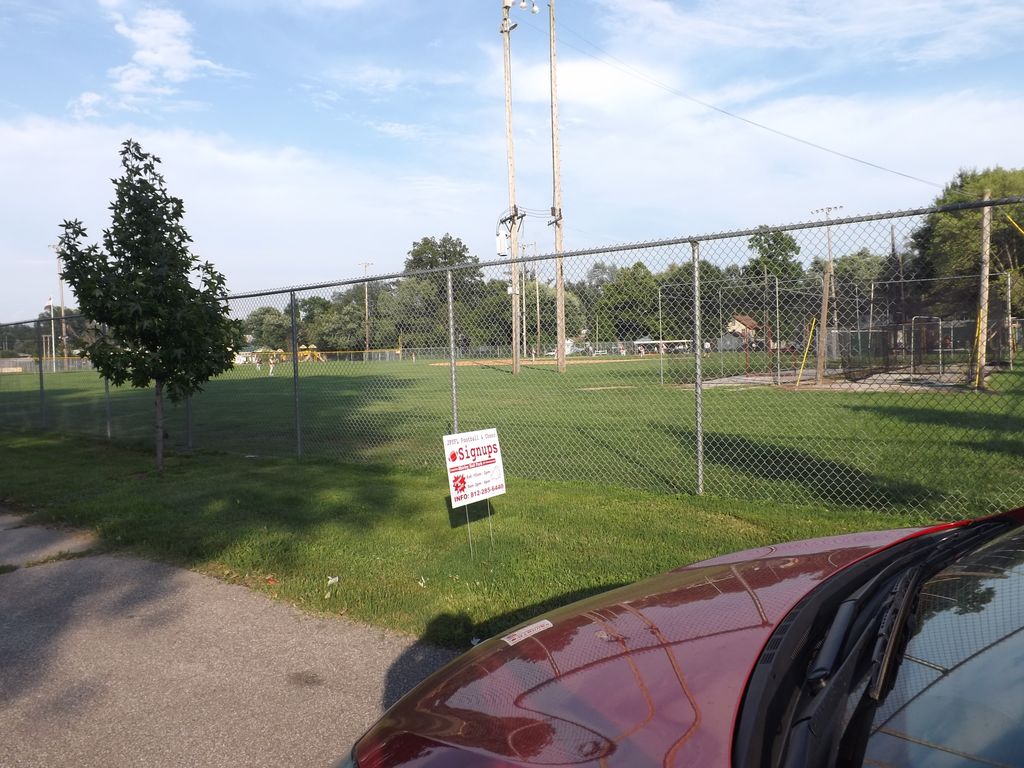
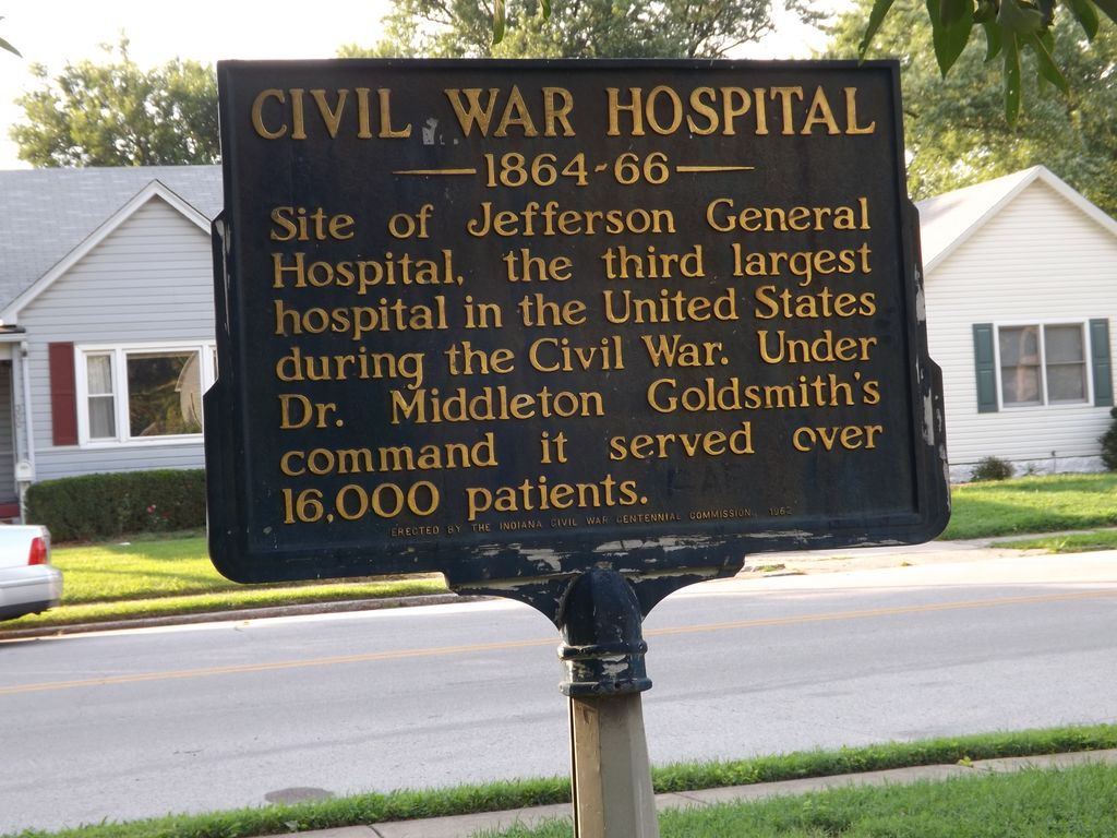
| Description | : | It has been noted in history that there are at least three locations in which Civil War soldiers who died at the Jeffersonville Civil War Hospitals were buried. One is Play Square located on Mulberry Street across from the new walking bridge; another is located on the actual grounds where the old hospital once stood (the old Masonic Bldg.); and the other is under the baseball fields behind Parkview Middle School. The original Civil War hospital was named Camp Joe Holt and was located close to the Mulberry Street burial grounds. There is a very nice memorial at that location.... Read More |
frequently asked questions (FAQ):
-
Where is Civil War Cemetery #2?
Civil War Cemetery #2 is located at E Park Place Jeffersonville, Clark County ,Indiana , 47130USA.
-
Civil War Cemetery #2 cemetery's updated grave count on graveviews.com?
0 memorials
-
Where are the coordinates of the Civil War Cemetery #2?
Latitude: 38.2818400
Longitude: -85.7206700
Nearby Cemetories:
1. Civil War Cemetery #3
Jeffersonville, Clark County, USA
Coordinate: 38.2848790, -85.7217790
2. Saint Anthony Cemetery
Jeffersonville, Clark County, USA
Coordinate: 38.2844009, -85.7281036
3. Eastern Cemetery
Jeffersonville, Clark County, USA
Coordinate: 38.2832985, -85.7292023
4. Old City Cemetery
Jeffersonville, Clark County, USA
Coordinate: 38.2706220, -85.7429770
5. Civil War Cemetery
Jeffersonville, Clark County, USA
Coordinate: 38.2705400, -85.7436300
6. Reformatory Cemetery
Clarksville, Clark County, USA
Coordinate: 38.2744460, -85.7544820
7. Walnut Ridge Cemetery
Jeffersonville, Clark County, USA
Coordinate: 38.3025017, -85.7466965
8. Hackberry Cemetery
Louisville, Jefferson County, USA
Coordinate: 38.2514500, -85.7032170
9. Cave Hill National Cemetery
Louisville, Jefferson County, USA
Coordinate: 38.2483800, -85.7196000
10. Eastern Cemetery
Louisville, Jefferson County, USA
Coordinate: 38.2470500, -85.7249100
11. Cave Hill Cemetery
Louisville, Jefferson County, USA
Coordinate: 38.2453600, -85.7146400
12. Fort Nelson Burial Ground
Louisville, Jefferson County, USA
Coordinate: 38.2575100, -85.7616140
13. Applegate Family Cemetery
Clarksville, Clark County, USA
Coordinate: 38.3100200, -85.7578400
14. Adams Family Cemetery (Defunct)
Jeffersonville, Clark County, USA
Coordinate: 38.3150300, -85.6887200
15. Cathedral of the Assumption
Louisville, Jefferson County, USA
Coordinate: 38.2525680, -85.7588370
16. First Unitarian Memorial Garden
Louisville, Jefferson County, USA
Coordinate: 38.2437920, -85.7583330
17. Espy Cemetery
Clark County, USA
Coordinate: 38.3276863, -85.7010498
18. Calvary Episcopal Church Burial Grounds
Louisville, Jefferson County, USA
Coordinate: 38.2437866, -85.7593283
19. Stewart-Emery Cemetery
Clarksville, Clark County, USA
Coordinate: 38.3120000, -85.7701310
20. Louisville Presbyterian Seminary Memorial Garden
Louisville, Jefferson County, USA
Coordinate: 38.2387380, -85.6861190
21. Arterburn Cemetery
Saint Matthews, Jefferson County, USA
Coordinate: 38.2552000, -85.6609900
22. Good Shepherd Convent Cemetery
Louisville, Jefferson County, USA
Coordinate: 38.2682070, -85.7881810
23. Fort George Cemetery
Louisville, Jefferson County, USA
Coordinate: 38.2320530, -85.7522260
24. Calvary Cemetery
Louisville, Jefferson County, USA
Coordinate: 38.2256300, -85.7134700