
| Memorials | : | 0 |
| Location | : | Jeffersonville, Clark County, USA |
| Coordinate | : | 38.2705400, -85.7436300 |
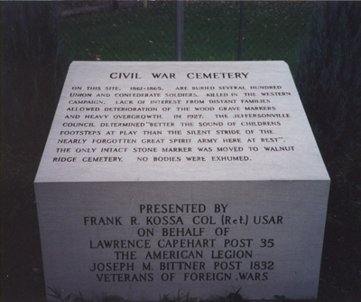
| Description | : | GPS for historical purposes only. Marker at site states:"On this site, 1861-1865, are buried several hundred Union and Confederate soldiers, killed in the Western campaign. Lack of interest from distant families allowed deterioration of the wood grave markers and heavy overgrowth. In 1927, the Jeffersonville Council determined, 'Better the sound of children's footsteps at play than the silent stride of the nearly forgotten great spirit army here at rest.' The only intact stone marker was moved to Walnut Ridge Cemetery. No bodies were exhumed." |
frequently asked questions (FAQ):
-
Where is Civil War Cemetery?
Civil War Cemetery is located at Jeffersonville, Clark County ,Indiana ,USA.
-
Civil War Cemetery cemetery's updated grave count on graveviews.com?
0 memorials
-
Where are the coordinates of the Civil War Cemetery?
Latitude: 38.2705400
Longitude: -85.7436300
Nearby Cemetories:
1. Old City Cemetery
Jeffersonville, Clark County, USA
Coordinate: 38.2706220, -85.7429770
2. Reformatory Cemetery
Clarksville, Clark County, USA
Coordinate: 38.2744460, -85.7544820
3. Eastern Cemetery
Jeffersonville, Clark County, USA
Coordinate: 38.2832985, -85.7292023
4. Saint Anthony Cemetery
Jeffersonville, Clark County, USA
Coordinate: 38.2844009, -85.7281036
5. Fort Nelson Burial Ground
Louisville, Jefferson County, USA
Coordinate: 38.2575100, -85.7616140
6. Civil War Cemetery #2
Jeffersonville, Clark County, USA
Coordinate: 38.2818400, -85.7206700
7. Cathedral of the Assumption
Louisville, Jefferson County, USA
Coordinate: 38.2525680, -85.7588370
8. Civil War Cemetery #3
Jeffersonville, Clark County, USA
Coordinate: 38.2848790, -85.7217790
9. Eastern Cemetery
Louisville, Jefferson County, USA
Coordinate: 38.2470500, -85.7249100
10. Cave Hill National Cemetery
Louisville, Jefferson County, USA
Coordinate: 38.2483800, -85.7196000
11. First Unitarian Memorial Garden
Louisville, Jefferson County, USA
Coordinate: 38.2437920, -85.7583330
12. Calvary Episcopal Church Burial Grounds
Louisville, Jefferson County, USA
Coordinate: 38.2437866, -85.7593283
13. Walnut Ridge Cemetery
Jeffersonville, Clark County, USA
Coordinate: 38.3025017, -85.7466965
14. Cave Hill Cemetery
Louisville, Jefferson County, USA
Coordinate: 38.2453600, -85.7146400
15. Good Shepherd Convent Cemetery
Louisville, Jefferson County, USA
Coordinate: 38.2682070, -85.7881810
16. Hackberry Cemetery
Louisville, Jefferson County, USA
Coordinate: 38.2514500, -85.7032170
17. Fort George Cemetery
Louisville, Jefferson County, USA
Coordinate: 38.2320530, -85.7522260
18. Applegate Family Cemetery
Clarksville, Clark County, USA
Coordinate: 38.3100200, -85.7578400
19. Stewart-Emery Cemetery
Clarksville, Clark County, USA
Coordinate: 38.3120000, -85.7701310
20. Portland Cemetery
Louisville, Jefferson County, USA
Coordinate: 38.2731018, -85.8058014
21. Louisville Cemetery
Louisville, Jefferson County, USA
Coordinate: 38.2226905, -85.7276820
22. Calvary Cemetery
Louisville, Jefferson County, USA
Coordinate: 38.2256300, -85.7134700
23. Jones Burying Ground
New Albany, Floyd County, USA
Coordinate: 38.2938000, -85.8039000
24. Grayson-Long Cemetery
Clark County, USA
Coordinate: 38.3147011, -85.7834015