
| Memorials | : | 0 |
| Location | : | Marbury-cum-Quoisley, Cheshire East Unitary Authority, England |
| Coordinate | : | 53.0062980, -2.6564160 |
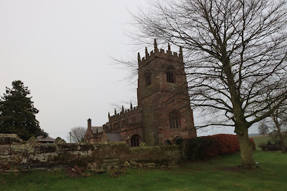
| Description | : | Also known as St Michael and All Angels, the church overlooks Big Mere at Marbury. A church has been on the site since 1299 but the present building dates from the 1400's. Extended in 1822 and restored in 1892 the building is Grade II* listed. The lych gate is dedicated as a memorial to those who fell in WW1 and is, along with the churchyard walls, is Grade II listed. There is one War Grave from WW1 in the churchyard |
frequently asked questions (FAQ):
-
Where is St Michael Churchyard?
St Michael Churchyard is located at Church Lane Marbury-cum-Quoisley, Cheshire East Unitary Authority ,Cheshire , SY13 4LNEngland.
-
St Michael Churchyard cemetery's updated grave count on graveviews.com?
0 memorials
-
Where are the coordinates of the St Michael Churchyard?
Latitude: 53.0062980
Longitude: -2.6564160
Nearby Cemetories:
1. Old St. Chad's Church and Cemetery
Tushingham, Cheshire West and Chester Unitary Authority, England
Coordinate: 53.0115193, -2.7061829
2. St Margaret Churchyard
Wrenbury-cum-Frith, Cheshire East Unitary Authority, England
Coordinate: 53.0256700, -2.6073340
3. St. Wenefredes Churchyard
Bickley, Cheshire West and Chester Unitary Authority, England
Coordinate: 53.0365490, -2.6924400
4. Bateman Memorial Chapel
Chorley, Cheshire East Unitary Authority, England
Coordinate: 53.0549000, -2.6368300
5. Christ Church
Ash Magna, Shropshire Unitary Authority, England
Coordinate: 52.9575430, -2.6287860
6. St Michael Churchyard
Baddiley, Cheshire East Unitary Authority, England
Coordinate: 53.0488780, -2.5905830
7. Malpas Cemetery
Malpas, Cheshire West and Chester Unitary Authority, England
Coordinate: 53.0262800, -2.7633600
8. St. Oswald's Churchyard
Malpas, Cheshire West and Chester Unitary Authority, England
Coordinate: 53.0194240, -2.7669350
9. United Reformed Church Burial Ground
Malpas, Cheshire West and Chester Unitary Authority, England
Coordinate: 53.0198355, -2.7673954
10. St John The Baptist Churchyard
Ightfield, Shropshire Unitary Authority, England
Coordinate: 52.9438900, -2.6081000
11. Holy Trinity Churchyard
Bickerton, Cheshire East Unitary Authority, England
Coordinate: 53.0770280, -2.7326350
12. Bickerton Municipal Cemetery
Bickerton, Cheshire East Unitary Authority, England
Coordinate: 53.0773110, -2.7329560
13. Calverhall Holy Trinity
Calverhall, Shropshire Unitary Authority, England
Coordinate: 52.9311270, -2.5917490
14. Coton Primitive Methodist Chapel
Cotonwood, Shropshire Unitary Authority, England
Coordinate: 52.9191890, -2.6926830
15. Brown Knoll Methodist Chapel
Broxton, Cheshire West and Chester Unitary Authority, England
Coordinate: 53.0766700, -2.7538600
16. St Mary Churchyard
Acton, Cheshire East Unitary Authority, England
Coordinate: 53.0737140, -2.5511740
17. Nantwich Quaker Burial Ground (Defunct)
Nantwich, Cheshire East Unitary Authority, England
Coordinate: 53.0645719, -2.5214206
18. Barker Street Chapel Chapelyard
Nantwich, Cheshire East Unitary Authority, England
Coordinate: 53.0658770, -2.5222890
19. St Mary's Church
Nantwich, Cheshire East Unitary Authority, England
Coordinate: 53.0671000, -2.5206000
20. Harthill Chester Churchyard
Harthill, Cheshire West and Chester Unitary Authority, England
Coordinate: 53.0924840, -2.7469490
21. St. John the Divine Churchyard
Burwardsley, Cheshire West and Chester Unitary Authority, England
Coordinate: 53.1035280, -2.7251110
22. St Peter Churchyard
Adderley, Shropshire Unitary Authority, England
Coordinate: 52.9517090, -2.5061580
23. Quaker Burial Ground at Stoke Nantwich
Stoke, Cheshire East Unitary Authority, England
Coordinate: 53.0989400, -2.5670000
24. St. John's Churchyard
Threapwood, Cheshire West and Chester Unitary Authority, England
Coordinate: 53.0023350, -2.8359540