
| Memorials | : | 0 |
| Location | : | Dyer, Gibson County, USA |
| Coordinate | : | 36.0778090, -89.0589010 |
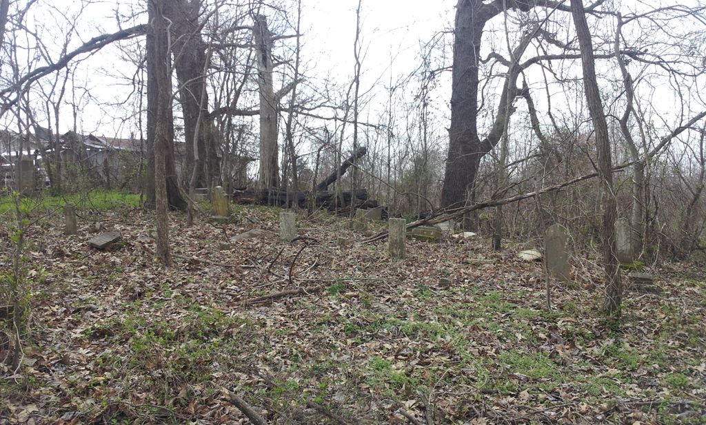
| Description | : | The Crenshaw burying grounds said to be halfway between Yorkville and Dyer, Tennessee. From intersection of TN-77 & TN-188, in Yorkville, travel east for 3.8 mi., to the cemetery on the north (left) side of the road about 200' from the roadway. |
frequently asked questions (FAQ):
-
Where is Crenshaw-Wyatt Cemetery?
Crenshaw-Wyatt Cemetery is located at 409 Dyer Hwy Dyer, Gibson County ,Tennessee , 38330USA.
-
Crenshaw-Wyatt Cemetery cemetery's updated grave count on graveviews.com?
0 memorials
-
Where are the coordinates of the Crenshaw-Wyatt Cemetery?
Latitude: 36.0778090
Longitude: -89.0589010
Nearby Cemetories:
1. Cowan Cemetery
Dyer, Gibson County, USA
Coordinate: 36.0978120, -89.0753020
2. Mount Olive Cemetery
Dyer, Gibson County, USA
Coordinate: 36.0807991, -89.0278015
3. Flowers - Wright Cemetery
Dyer, Gibson County, USA
Coordinate: 36.0951100, -89.0348700
4. Thompson Cemetery
Rutherford, Gibson County, USA
Coordinate: 36.1047220, -89.0553430
5. Good Hope Cemetery
Dyer, Gibson County, USA
Coordinate: 36.0477982, -89.0438995
6. Balentine Family Cemetery
Dyer, Gibson County, USA
Coordinate: 36.0544690, -89.0928070
7. Bells Chapel Cemetery
Dyer, Gibson County, USA
Coordinate: 36.1164017, -89.0686035
8. Taylor Family Cemetery
Rutherford, Gibson County, USA
Coordinate: 36.1049700, -89.0226300
9. Hogue Cemetery
Yorkville, Gibson County, USA
Coordinate: 36.0495580, -89.0985780
10. Wilkes Cemetery
Rutherford, Gibson County, USA
Coordinate: 36.1097380, -89.0214500
11. Clear Creek Cemetery
Currie, Gibson County, USA
Coordinate: 36.0400009, -89.0299988
12. Duck Hill Cemetery
Trenton, Gibson County, USA
Coordinate: 36.0331001, -89.0413971
13. Bethel Cemetery
Yorkville, Gibson County, USA
Coordinate: 36.0871370, -89.1178680
14. Bethel MB Church Cemetery
Yorkville, Gibson County, USA
Coordinate: 36.0878910, -89.1180910
15. Flowers Chapel Cemetery
Rutherford, Gibson County, USA
Coordinate: 36.1198820, -89.0265080
16. Hall Family Cemetery
Dyer, Gibson County, USA
Coordinate: 36.0302900, -89.0393600
17. Yorkville Cemetery
Yorkville, Gibson County, USA
Coordinate: 36.0980988, -89.1207962
18. Yorkville Cumberland Presbyterian Church Cemetery
Yorkville, Gibson County, USA
Coordinate: 36.1007996, -89.1231003
19. Hopper Cemetery
Dyer, Gibson County, USA
Coordinate: 36.0936200, -88.9878680
20. Bobbitt Cemetery
Dyer, Gibson County, USA
Coordinate: 36.0774994, -88.9850006
21. Oakwood Cemetery
Dyer, Gibson County, USA
Coordinate: 36.0619011, -88.9875031
22. Keas Cemetery
Dyer, Gibson County, USA
Coordinate: 36.0769005, -88.9757996
23. Rutherford Cemetery
Rutherford, Gibson County, USA
Coordinate: 36.1258011, -88.9989014
24. Liberty Grove Cemetery
Rutherford, Gibson County, USA
Coordinate: 36.1439760, -89.0371100