
| Memorials | : | 0 |
| Location | : | Culemborg, Culemborg Municipality, Netherlands |
| Coordinate | : | 51.9632800, 5.2311300 |
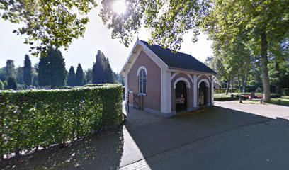
| Description | : | The town of Culemborg is situated to the north-west of Tiel off the A2 motorway. From the A2 motorway, which runs between Utrecht and 'S Hertogenbosch, turn off at Culemborg and follow the N320 in the direction of Culemborg. Cross over the railway and keep following the main road past the town. When the road bears round to the right, take the first turning on the left, cross over the water and turn left again into Voorkoopstraat. Follow this road straight on into Weithusen and Honddijk. At the end of Honddijk turn left into Lange Dreef, then follow the road... Read More |
frequently asked questions (FAQ):
-
Where is Culemborg General Cemetery?
Culemborg General Cemetery is located at Culemborg, Culemborg Municipality ,Gelderland ,Netherlands.
-
Culemborg General Cemetery cemetery's updated grave count on graveviews.com?
0 memorials
-
Where are the coordinates of the Culemborg General Cemetery?
Latitude: 51.9632800
Longitude: 5.2311300
Nearby Cemetories:
1. Joodse begraafplaats Culemborg
Culemborg Municipality, Netherlands
Coordinate: 51.9626100, 5.2322500
2. Schalkwijk Protestant Churchyard
Schalkwijk, Houten Municipality, Netherlands
Coordinate: 51.9910100, 5.1933300
3. Beusichem Algemene Begraafplaats
Beusichem, Buren Municipality, Netherlands
Coordinate: 51.9482800, 5.2960800
4. Schalkwijk Roman Catholic Cemetery
Schalkwijk, Houten Municipality, Netherlands
Coordinate: 51.9949500, 5.1845200
5. Wijk-Bij-Duurstede General Cemetery
Wijk bij Duurstede, Wijk bij Duurstede Municipality, Netherlands
Coordinate: 51.9751800, 5.3388600
6. Joodse Begraafplaats Heijmanspad
Wijk bij Duurstede Municipality, Netherlands
Coordinate: 51.9709900, 5.3428500
7. Joodse Begraafplaats Beesd
Beesd, Geldermalsen Municipality, Netherlands
Coordinate: 51.8986210, 5.1895010
8. Joodse Begraafplaats Steenstraat
Wijk bij Duurstede Municipality, Netherlands
Coordinate: 51.9757500, 5.3432200
9. Tull En 't Waal Protestant Cemetery
Tull en 't Waal, Houten Municipality, Netherlands
Coordinate: 52.0017900, 5.1330300
10. Hervormde Begraafplaats Nederlangbroek
Langbroek, Wijk bij Duurstede Municipality, Netherlands
Coordinate: 52.0114502, 5.3274783
11. R.K. Begraafplaats Buren
Buren, Buren Municipality, Netherlands
Coordinate: 51.9090374, 5.3216018
12. Joodse begraafplaats
Buren Municipality, Netherlands
Coordinate: 51.9125800, 5.3296490
13. Buren Old General Cemetery
Buren, Buren Municipality, Netherlands
Coordinate: 51.9122100, 5.3298600
14. Buurmalsen General Cemetery
Buurmalsen, Geldermalsen Municipality, Netherlands
Coordinate: 51.8873500, 5.2817100
15. Vianen Protestant Cemetery
Vianen, Vianen Municipality, Netherlands
Coordinate: 51.9867800, 5.0891100
16. Joodse Begraafplaats
Vianen Municipality, Netherlands
Coordinate: 51.9862400, 5.0874000
17. Vreeswijk Protestant Cemetery
Vreeswijk, Nieuwegein Municipality, Netherlands
Coordinate: 52.0048700, 5.0974600
18. Geldermalsen General Cemetery
Geldermalsen, Geldermalsen Municipality, Netherlands
Coordinate: 51.8804000, 5.2984400
19. R.K. Begraafplaats Drieklinken
Driebergen-Rijsenburg, Utrechtse Heuvelrug Municipality, Netherlands
Coordinate: 52.0535356, 5.2747502
20. Huis Doorn
Doorn, Utrechtse Heuvelrug Municipality, Netherlands
Coordinate: 52.0314140, 5.3386660
21. Begraafplaats Meteren
Meteren, Geldermalsen Municipality, Netherlands
Coordinate: 51.8686615, 5.2737818
22. Doorn Nieuwe Algemene Begraafplaats
Doorn, Utrechtse Heuvelrug Municipality, Netherlands
Coordinate: 52.0484200, 5.3203200
23. Joodse Begraafplaats
Geldermalsen Municipality, Netherlands
Coordinate: 51.8713890, 5.3025000
24. Heicop General Cemetery
Hei- en Boeicop, Zederik Municipality, Netherlands
Coordinate: 51.9478600, 5.0672500