
| Memorials | : | 0 |
| Location | : | Culemborg Municipality, Netherlands |
| Coordinate | : | 51.9626100, 5.2322500 |
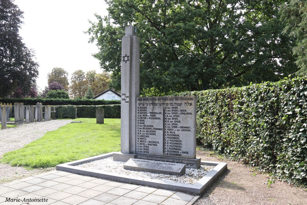
| Description | : | Beginning in 1869, Culemborg Jews were buried in a separate section of the town's public cemetery, located on the Achterweg. The Jewish cemetery consists of three sections. The first is the actual new cemetery; the second is where the remains of the original cemetery on the Westerwal are reburied; the childrens section is the last section. The oldest grave is in the right rear corner. |
frequently asked questions (FAQ):
-
Where is Joodse begraafplaats Culemborg?
Joodse begraafplaats Culemborg is located at Achterweg Culemborg Municipality ,Gelderland ,Netherlands.
-
Joodse begraafplaats Culemborg cemetery's updated grave count on graveviews.com?
0 memorials
-
Where are the coordinates of the Joodse begraafplaats Culemborg?
Latitude: 51.9626100
Longitude: 5.2322500
Nearby Cemetories:
1. Culemborg General Cemetery
Culemborg, Culemborg Municipality, Netherlands
Coordinate: 51.9632800, 5.2311300
2. Schalkwijk Protestant Churchyard
Schalkwijk, Houten Municipality, Netherlands
Coordinate: 51.9910100, 5.1933300
3. Beusichem Algemene Begraafplaats
Beusichem, Buren Municipality, Netherlands
Coordinate: 51.9482800, 5.2960800
4. Schalkwijk Roman Catholic Cemetery
Schalkwijk, Houten Municipality, Netherlands
Coordinate: 51.9949500, 5.1845200
5. Wijk-Bij-Duurstede General Cemetery
Wijk bij Duurstede, Wijk bij Duurstede Municipality, Netherlands
Coordinate: 51.9751800, 5.3388600
6. Joodse Begraafplaats Heijmanspad
Wijk bij Duurstede Municipality, Netherlands
Coordinate: 51.9709900, 5.3428500
7. Joodse Begraafplaats Beesd
Beesd, Geldermalsen Municipality, Netherlands
Coordinate: 51.8986210, 5.1895010
8. Joodse Begraafplaats Steenstraat
Wijk bij Duurstede Municipality, Netherlands
Coordinate: 51.9757500, 5.3432200
9. Tull En 't Waal Protestant Cemetery
Tull en 't Waal, Houten Municipality, Netherlands
Coordinate: 52.0017900, 5.1330300
10. Hervormde Begraafplaats Nederlangbroek
Langbroek, Wijk bij Duurstede Municipality, Netherlands
Coordinate: 52.0114502, 5.3274783
11. R.K. Begraafplaats Buren
Buren, Buren Municipality, Netherlands
Coordinate: 51.9090374, 5.3216018
12. Joodse begraafplaats
Buren Municipality, Netherlands
Coordinate: 51.9125800, 5.3296490
13. Buren Old General Cemetery
Buren, Buren Municipality, Netherlands
Coordinate: 51.9122100, 5.3298600
14. Buurmalsen General Cemetery
Buurmalsen, Geldermalsen Municipality, Netherlands
Coordinate: 51.8873500, 5.2817100
15. Vianen Protestant Cemetery
Vianen, Vianen Municipality, Netherlands
Coordinate: 51.9867800, 5.0891100
16. Geldermalsen General Cemetery
Geldermalsen, Geldermalsen Municipality, Netherlands
Coordinate: 51.8804000, 5.2984400
17. Joodse Begraafplaats
Vianen Municipality, Netherlands
Coordinate: 51.9862400, 5.0874000
18. Vreeswijk Protestant Cemetery
Vreeswijk, Nieuwegein Municipality, Netherlands
Coordinate: 52.0048700, 5.0974600
19. R.K. Begraafplaats Drieklinken
Driebergen-Rijsenburg, Utrechtse Heuvelrug Municipality, Netherlands
Coordinate: 52.0535356, 5.2747502
20. Huis Doorn
Doorn, Utrechtse Heuvelrug Municipality, Netherlands
Coordinate: 52.0314140, 5.3386660
21. Begraafplaats Meteren
Meteren, Geldermalsen Municipality, Netherlands
Coordinate: 51.8686615, 5.2737818
22. Joodse Begraafplaats
Geldermalsen Municipality, Netherlands
Coordinate: 51.8713890, 5.3025000
23. Doorn Nieuwe Algemene Begraafplaats
Doorn, Utrechtse Heuvelrug Municipality, Netherlands
Coordinate: 52.0484200, 5.3203200
24. Heicop General Cemetery
Hei- en Boeicop, Zederik Municipality, Netherlands
Coordinate: 51.9478600, 5.0672500