| Memorials | : | 0 |
| Location | : | Springfield, Greene County, USA |
| Coordinate | : | 37.2516020, -93.2913170 |
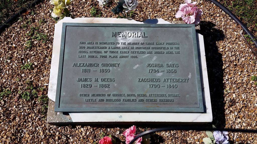
| Description | : | Section 1 Township 29N Range 22W Campbell Township, Springfield, Greene, Missouri. Cemetery location on grounds of Maranatha Village. The property was homesteaded by Joshua Davis and stayed in the family until 1947. The property was sold in 1958 to Assemblies of God, Book 1508, page 698, Greene County Recorders Office. The Dysart Cemetery Association formed, the marker was placed on the cemetery. Approx. 100 descendants. Reported about 90 graves. The marker reads: Memorial This area is dedicated to the memory of those early pioneers who homesteaded a large area in northern Springfield in the 1830's. Several of those early settlers are buried here.... Read More |
frequently asked questions (FAQ):
-
Where is Dysart Cemetery?
Dysart Cemetery is located at 233 E Norton Road Springfield, Greene County ,Missouri , 65803USA.
-
Dysart Cemetery cemetery's updated grave count on graveviews.com?
0 memorials
-
Where are the coordinates of the Dysart Cemetery?
Latitude: 37.2516020
Longitude: -93.2913170
Nearby Cemetories:
1. Doling Park
Springfield, Greene County, USA
Coordinate: 37.2461815, -93.2902374
2. Greenlawn Memorial Gardens
Springfield, Greene County, USA
Coordinate: 37.2611008, -93.2750015
3. Banfield Cemetery
Greene County, USA
Coordinate: 37.2779400, -93.3071900
4. Christ Episcopal Church Columbarium
Springfield, Greene County, USA
Coordinate: 37.2071800, -93.2862800
5. Keet Burial
Springfield, Greene County, USA
Coordinate: 37.2069190, -93.2883940
6. Bellview Cemetery
Springfield, Greene County, USA
Coordinate: 37.2880287, -93.2539215
7. Eastlawn Cemetery
Springfield, Greene County, USA
Coordinate: 37.2155991, -93.2514038
8. Antioch Cemetery
Springfield, Greene County, USA
Coordinate: 37.2505989, -93.3538971
9. Lincoln Memorial Park Cemetery
Springfield, Greene County, USA
Coordinate: 37.2108002, -93.2518997
10. Wilson Cemetery
Robberson Number 2 Township, Greene County, USA
Coordinate: 37.2894530, -93.3388070
11. Sac River Cemetery AKA Slave Cemetery
Robberson Number 2 Township, Greene County, USA
Coordinate: 37.2898990, -93.3398060
12. Saint Marys Cemetery
Springfield, Greene County, USA
Coordinate: 37.2038994, -93.3249969
13. Union Campground Cemetery
Springfield, Greene County, USA
Coordinate: 37.2609400, -93.2234000
14. Maple Park Cemetery
Springfield, Greene County, USA
Coordinate: 37.1944008, -93.2921982
15. Hancock-Morton-Westmoreland Cemetery
Greene County, USA
Coordinate: 37.2489014, -93.2133026
16. Friends of the Family Pet Memorial Gardens
Springfield, Greene County, USA
Coordinate: 37.2323600, -93.3673400
17. Mullings Family Cemetery
Greene County, USA
Coordinate: 37.3111110, -93.3197520
18. Alms House Cemetery
Springfield, Greene County, USA
Coordinate: 37.2319720, -93.3712130
19. Rountree Cemetery
Springfield, Greene County, USA
Coordinate: 37.1913532, -93.3367156
20. Resurrection Cemetery
Springfield, Greene County, USA
Coordinate: 37.2276200, -93.3747550
21. Fielder Langston Cemetery
Springfield, Greene County, USA
Coordinate: 37.1873700, -93.2479700
22. Rose Cemetery
Springfield, Greene County, USA
Coordinate: 37.1851470, -93.3462860
23. Temple Israel Cemetery
Springfield, Greene County, USA
Coordinate: 37.1730995, -93.2664032
24. Gorman and Scharpf Mortuary Columbarium
Springfield, Greene County, USA
Coordinate: 37.1746900, -93.2593800

