
| Memorials | : | 1 |
| Location | : | Greene County, USA |
| Coordinate | : | 37.2779400, -93.3071900 |
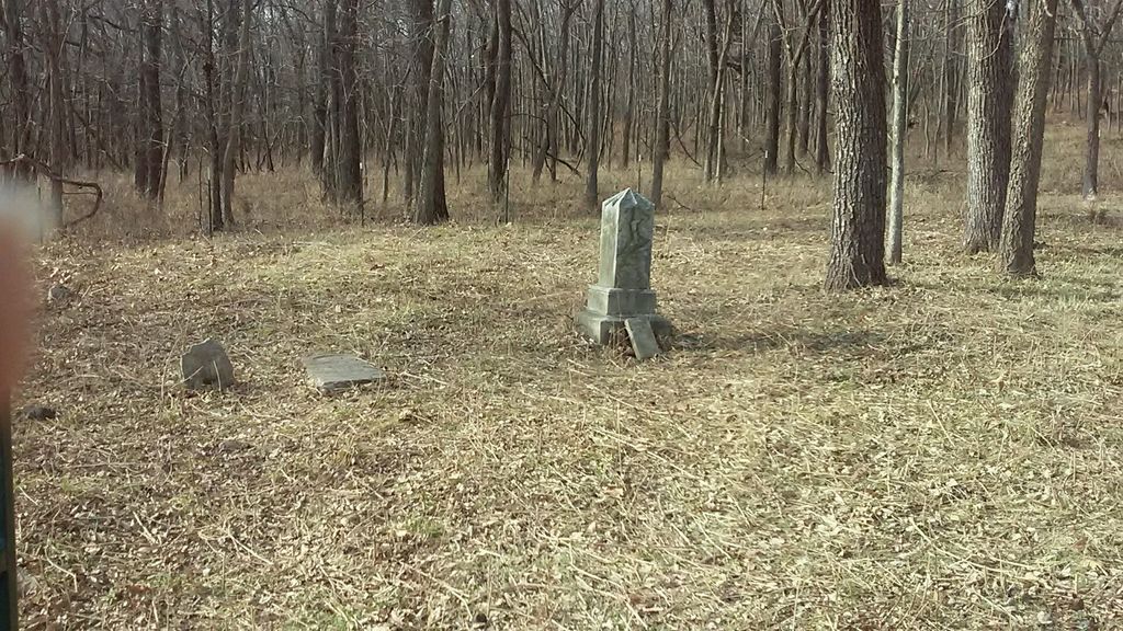
| Description | : | Banfield Cemetery is about 1/2 mile west of the Lost Hill Park parking lot near the Ozarks Greenway Trail. The cemetery covers about 1/2 acre. It is fenced and has recently (2017) been cleared of brush. There are only three graves marked with inscribed gravestones. There appear to be many other graves with only field stone markers or ground indentations. |
frequently asked questions (FAQ):
-
Where is Banfield Cemetery?
Banfield Cemetery is located at Greene County ,Missouri ,USA.
-
Banfield Cemetery cemetery's updated grave count on graveviews.com?
1 memorials
-
Where are the coordinates of the Banfield Cemetery?
Latitude: 37.2779400
Longitude: -93.3071900
Nearby Cemetories:
1. Wilson Cemetery
Robberson Number 2 Township, Greene County, USA
Coordinate: 37.2894530, -93.3388070
2. Sac River Cemetery AKA Slave Cemetery
Robberson Number 2 Township, Greene County, USA
Coordinate: 37.2898990, -93.3398060
3. Dysart Cemetery
Springfield, Greene County, USA
Coordinate: 37.2516020, -93.2913170
4. Greenlawn Memorial Gardens
Springfield, Greene County, USA
Coordinate: 37.2611008, -93.2750015
5. Doling Park
Springfield, Greene County, USA
Coordinate: 37.2461815, -93.2902374
6. Mullings Family Cemetery
Greene County, USA
Coordinate: 37.3111110, -93.3197520
7. Bellview Cemetery
Springfield, Greene County, USA
Coordinate: 37.2880287, -93.2539215
8. Antioch Cemetery
Springfield, Greene County, USA
Coordinate: 37.2505989, -93.3538971
9. Friends of the Family Pet Memorial Gardens
Springfield, Greene County, USA
Coordinate: 37.2323600, -93.3673400
10. Mount Comfort Cemetery
Springfield, Greene County, USA
Coordinate: 37.3250010, -93.2475450
11. Alms House Cemetery
Springfield, Greene County, USA
Coordinate: 37.2319720, -93.3712130
12. Union Campground Cemetery
Springfield, Greene County, USA
Coordinate: 37.2609400, -93.2234000
13. Keet Burial
Springfield, Greene County, USA
Coordinate: 37.2069190, -93.2883940
14. Christ Episcopal Church Columbarium
Springfield, Greene County, USA
Coordinate: 37.2071800, -93.2862800
15. Resurrection Cemetery
Springfield, Greene County, USA
Coordinate: 37.2276200, -93.3747550
16. Saint Marys Cemetery
Springfield, Greene County, USA
Coordinate: 37.2038994, -93.3249969
17. Eastlawn Cemetery
Springfield, Greene County, USA
Coordinate: 37.2155991, -93.2514038
18. Robberson Prairie Cemetery
Ebenezer, Greene County, USA
Coordinate: 37.3522600, -93.3366900
19. Hancock-Morton-Westmoreland Cemetery
Greene County, USA
Coordinate: 37.2489014, -93.2133026
20. Lincoln Memorial Park Cemetery
Springfield, Greene County, USA
Coordinate: 37.2108002, -93.2518997
21. Maple Park Cemetery
Springfield, Greene County, USA
Coordinate: 37.1944008, -93.2921982
22. White Chapel Memorial Gardens
Springfield, Greene County, USA
Coordinate: 37.2252998, -93.3906021
23. Rountree Cemetery
Springfield, Greene County, USA
Coordinate: 37.1913532, -93.3367156
24. Liberty Cemetery
Springfield, Greene County, USA
Coordinate: 37.3192000, -93.1993900