
| Memorials | : | 0 |
| Location | : | Napoleon, Randolph County, USA |
| Coordinate | : | 33.3204560, -85.3494260 |
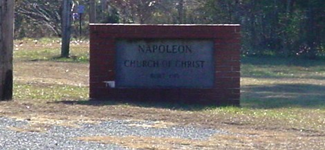
| Description | : | East Napoleon Church of Christ is east of Napoleon, but the post office is located in Woodland. From Napoleon, take County Road 56 to County Road 621 and go south. The map was determined by using online data which indicated the church is at Township 19, Range 12, Section 36 in Randolph County, Alabama, so it may not be exact. |
frequently asked questions (FAQ):
-
Where is East Napoleon Church of Christ Cemetery?
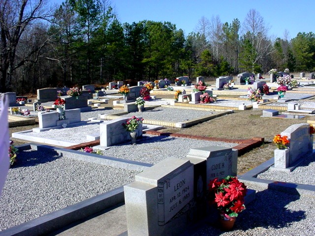
East Napoleon Church of Christ Cemetery is located at 2013 CR-621 Napoleon, Randolph County ,Alabama , 36280USA.
-
East Napoleon Church of Christ Cemetery cemetery's updated grave count on graveviews.com?
0 memorials
-
Where are the coordinates of the East Napoleon Church of Christ Cemetery?
Latitude: 33.3204560
Longitude: -85.3494260
Nearby Cemetories:
1. West Napoleon Church of Christ Cemetery
Napoleon, Randolph County, USA
Coordinate: 33.3244900, -85.3582600
2. Mount Carmel Cemetery
Randolph County, USA
Coordinate: 33.3498650, -85.3439040
3. Haywood Cemetery
Haywood, Randolph County, USA
Coordinate: 33.3039700, -85.3899100
4. Old Rocky Branch Cemetery
New Hope, Randolph County, USA
Coordinate: 33.3171997, -85.3977966
5. Rocky Branch Baptist Church Cemetery
New Hope, Randolph County, USA
Coordinate: 33.3217087, -85.3998795
6. Highway Ridge Memorial Gardens
Randolph County, USA
Coordinate: 33.2778015, -85.3486023
7. Potash Church Of God Cemetery
Potash, Randolph County, USA
Coordinate: 33.2776900, -85.3489900
8. Highway First Congregational Cemetery
Roanoke, Randolph County, USA
Coordinate: 33.2768000, -85.3539700
9. Big Springs Cemetery
Roanoke, Randolph County, USA
Coordinate: 33.2873400, -85.3133160
10. Liberty East Baptist Church Cemetery
Omaha, Randolph County, USA
Coordinate: 33.3401230, -85.3005940
11. Flat Rock Congregational Methodist Cemetery
Omaha, Randolph County, USA
Coordinate: 33.3365173, -85.2920609
12. Noon Day Congregational Christian Church Cemetery
New Hope, Randolph County, USA
Coordinate: 33.3265800, -85.4250400
13. Greens Chapel Methodist Church Cemetery
Randolph County, USA
Coordinate: 33.2949510, -85.4256740
14. High Point Church of God Cemetery
Franklin, Heard County, USA
Coordinate: 33.3163986, -85.2636032
15. Liberty Grove Church Cemetery
Randolph County, USA
Coordinate: 33.3569020, -85.4286910
16. Providence Baptist Church Cemetery
Providence, Randolph County, USA
Coordinate: 33.3970110, -85.3712540
17. Red Oak Cemetery
Heard County, USA
Coordinate: 33.3506012, -85.2621994
18. Daniel Family Cemetery
Graham, Randolph County, USA
Coordinate: 33.3956100, -85.3200000
19. Friendship Christian Cemetery
Roanoke, Randolph County, USA
Coordinate: 33.2585810, -85.4187610
20. Ridgeway Cemetery
Heard County, USA
Coordinate: 33.3046989, -85.2493973
21. Beulah Baptist Church Cemetery
Roanoke, Randolph County, USA
Coordinate: 33.2667007, -85.2630997
22. Daniel-McDow Cemetery
Graham, Randolph County, USA
Coordinate: 33.4088000, -85.3214800
23. Wehadkee Missionary Baptist Church Cemetery
Roanoke, Randolph County, USA
Coordinate: 33.2237960, -85.3318520
24. Macedonia Cemetery
Frolona, Heard County, USA
Coordinate: 33.3493996, -85.2347031