
| Memorials | : | 0 |
| Location | : | Thorney, Peterborough Unitary Authority, England |
| Coordinate | : | 52.6204590, -0.1072060 |
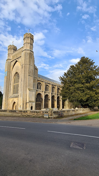
| Description | : | Thorney Abbey, now the Church of St Mary and St Botolph, was a medieval monastic house established on the island of Thorney in The Fens of Cambridgeshire, England. The earliest documentary sources refer to a mid-7th century hermitage destroyed by a Viking incursion in the late 9th century. A Benedictine monastery was founded in the 972, when Ethelwold, Bishop of Winchester, bought it from a woman named Ethelfled, into whose hands it had come, and established a monastery there. A huge rebuilding programme followed the Norman Conquest of 1066. A new church was begun under the abbacy of Gunther of Le... Read More |
frequently asked questions (FAQ):
-
Where is Thorney Abbey?
Thorney Abbey is located at Thorney, Peterborough Unitary Authority ,Cambridgeshire ,England.
-
Thorney Abbey cemetery's updated grave count on graveviews.com?
0 memorials
-
Where are the coordinates of the Thorney Abbey?
Latitude: 52.6204590
Longitude: -0.1072060
Nearby Cemetories:
1. St. Mary and St. Botolph Churchyard
Thorney, Peterborough Unitary Authority, England
Coordinate: 52.6204260, -0.1069770
2. Thorney Cemetery
Thorney, Peterborough Unitary Authority, England
Coordinate: 52.6163700, -0.1044200
3. Eye Cemetery
Eye, Peterborough Unitary Authority, England
Coordinate: 52.6110938, -0.1859580
4. Saint Matthew's Churchyard
Eye, Peterborough Unitary Authority, England
Coordinate: 52.6094813, -0.1866602
5. Holy Trinity Churchyard
Coates, Fenland District, England
Coordinate: 52.5626500, -0.0756700
6. Whittlesey Cemetery
Whittlesey, Fenland District, England
Coordinate: 52.5583700, -0.1232450
7. Saint Mary's Churchyard
Whittlesey, Fenland District, England
Coordinate: 52.5556600, -0.1278000
8. Crowland Abbey
Crowland, South Holland District, England
Coordinate: 52.6763800, -0.1654240
9. St. Andrew's Churchyard
Whittlesey, Fenland District, England
Coordinate: 52.5558673, -0.1330800
10. St Bartholomew Churchyard
Newborough, Peterborough Unitary Authority, England
Coordinate: 52.6385360, -0.2223780
11. Eastfield Cemetery
Peterborough, Peterborough Unitary Authority, England
Coordinate: 52.5890690, -0.2225360
12. Holy Trinity Churchyard
Gedney Hill, South Holland District, England
Coordinate: 52.6826080, -0.0211840
13. Broadway Cemetery
Peterborough, Peterborough Unitary Authority, England
Coordinate: 52.5796750, -0.2350260
14. Emmanual Anglican Cemetery
Parson Drove, Fenland District, England
Coordinate: 52.6574955, 0.0285929
15. St. John the Baptist Churchyard
Whaplode Drove, South Holland District, England
Coordinate: 52.7034435, -0.0476688
16. All Saints Churchyard
Paston, Peterborough Unitary Authority, England
Coordinate: 52.6053690, -0.2576130
17. Peterborough Cathedral
Peterborough, Peterborough Unitary Authority, England
Coordinate: 52.5725280, -0.2392390
18. St. John the Baptist Church
Peterborough, Peterborough Unitary Authority, England
Coordinate: 52.5727200, -0.2438210
19. Fletton Cemetery
Fletton, Peterborough Unitary Authority, England
Coordinate: 52.5611534, -0.2350550
20. St. Margaret's churchyard
Fletton, Peterborough Unitary Authority, England
Coordinate: 52.5584400, -0.2350100
21. Stanground Cemetery
Stanground, Peterborough Unitary Authority, England
Coordinate: 52.5516860, -0.2273100
22. Saint John the Baptist Churchyard
Werrington, Peterborough Unitary Authority, England
Coordinate: 52.6134500, -0.2734500
23. Saint Pegas Churchyard
Peakirk, Peterborough Unitary Authority, England
Coordinate: 52.6454940, -0.2744530
24. Woodston Cemetery
Woodston, Peterborough Unitary Authority, England
Coordinate: 52.5607090, -0.2529700