
| Memorials | : | 0 |
| Location | : | Wednesbury, Metropolitan Borough of Sandwell, England |
| Coordinate | : | 52.5689100, -2.0182820 |
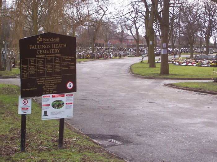
| Description | : | The development of the cemetery was considered to be a significant stage in the overall development of the Borough of Wednesbury and the work which transformed the land was carried out under deplorable conditions. The unemployed were set to work levelling the ground during one of the worst winters on record. The cemetery was formally opened and consecrated on September 22nd 1936 by the Bishop of Stafford, the Rvd D. H. Crick, who was previously the Vicar of Wednesbury. The gates were opened using a key specially presented to the Bishop. The Mayor, Alderman B. W. Griffiths, gave a speech explaining how... Read More |
frequently asked questions (FAQ):
-
Where is Fallings Heath Cemetery?
Fallings Heath Cemetery is located at Beebee Road Wednesbury, Metropolitan Borough of Sandwell ,West Midlands , WS10 9RXEngland.
-
Fallings Heath Cemetery cemetery's updated grave count on graveviews.com?
0 memorials
-
Where are the coordinates of the Fallings Heath Cemetery?
Latitude: 52.5689100
Longitude: -2.0182820
Nearby Cemetories:
1. James Bridge Cemetery
Darlaston, Metropolitan Borough of Walsall, England
Coordinate: 52.5765076, -2.0185659
2. All Saints Churchyard
Moxley, Metropolitan Borough of Walsall, England
Coordinate: 52.5666000, -2.0350200
3. Wood Green Cemetery
Wednesbury, Metropolitan Borough of Sandwell, England
Coordinate: 52.5585990, -2.0081480
4. St. John's Church
Wednesbury, Metropolitan Borough of Sandwell, England
Coordinate: 52.5506170, -2.0184700
5. Queen Street Cemetery
Walsall, Metropolitan Borough of Walsall, England
Coordinate: 52.5797190, -1.9929050
6. Bentley Cemetery
Willenhall, Metropolitan Borough of Walsall, England
Coordinate: 52.5868880, -2.0299620
7. St Mary Roman Catholic Churchyard
Walsall, Metropolitan Borough of Walsall, England
Coordinate: 52.5797300, -1.9835900
8. St Giles Church Cemetery
Willenhall, Metropolitan Borough of Walsall, England
Coordinate: 52.5841600, -2.0504000
9. St. Giles Church Cholera Burial Ground
Willenhall, Metropolitan Borough of Coventry, England
Coordinate: 52.5851060, -2.0498580
10. Bath Street Burial Grounds
Walsall, Metropolitan Borough of Walsall, England
Coordinate: 52.5801310, -1.9799960
11. Wood Street Cemetery
Willenhall, Metropolitan Borough of Walsall, England
Coordinate: 52.5867500, -2.0528900
12. St. Mary's
Bilston, Metropolitan Borough of Wolverhampton, England
Coordinate: 52.5639000, -2.0681000
13. Willenhall Lawn Cemetery
Willenhall, Metropolitan Borough of Walsall, England
Coordinate: 52.6001870, -2.0327110
14. St. Leonard's Churchyard
Bilston, Metropolitan Borough of Wolverhampton, England
Coordinate: 52.5665580, -2.0752470
15. Hall Green Cemetery
Bradley, Stafford Borough, England
Coordinate: 52.5525360, -2.0728930
16. Holy Trinity Churchyard Shortheath
Willenhall, Metropolitan Borough of Walsall, England
Coordinate: 52.6047160, -2.0364190
17. Heath Lane Cemetery
West Bromwich, Metropolitan Borough of Sandwell, England
Coordinate: 52.5355750, -1.9885610
18. All Saints Churchyard
West Bromwich, Metropolitan Borough of Sandwell, England
Coordinate: 52.5344360, -1.9849140
19. Tipton Cemetery
Tipton, Metropolitan Borough of Sandwell, England
Coordinate: 52.5321870, -2.0465760
20. Bilston Cemetery
Bilston, Metropolitan Borough of Wolverhampton, England
Coordinate: 52.5709000, -2.0862800
21. Ryecroft Cemetery
Walsall, Metropolitan Borough of Walsall, England
Coordinate: 52.6012820, -1.9752140
22. Christ Churchyard
Coseley, Metropolitan Borough of Dudley, England
Coordinate: 52.5463520, -2.0798570
23. Darkhouse Baptist Chapel Cemetery
Sedgley, Metropolitan Borough of Dudley, England
Coordinate: 52.5495697, -2.0834915
24. St. Martins Parish Church Pepper Box
Tipton, Metropolitan Borough of Sandwell, England
Coordinate: 52.5281400, -2.0495030