
| Memorials | : | 0 |
| Location | : | Eaton Center, Carroll County, USA |
| Coordinate | : | 43.9145100, -71.0039600 |
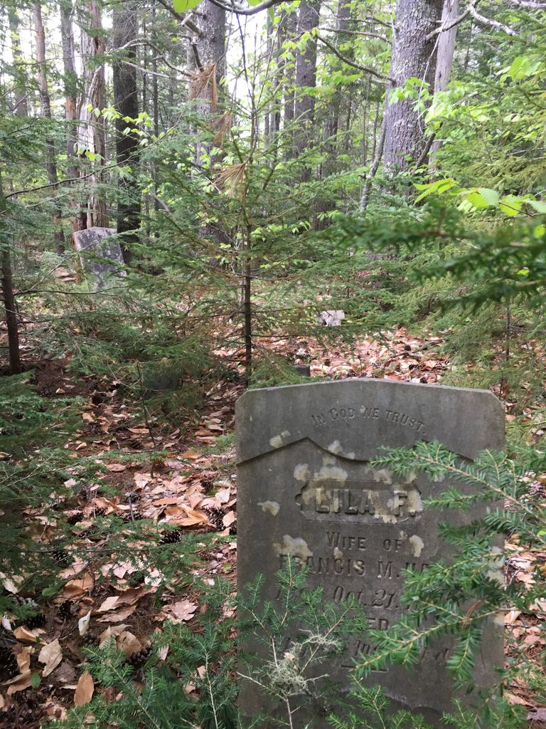
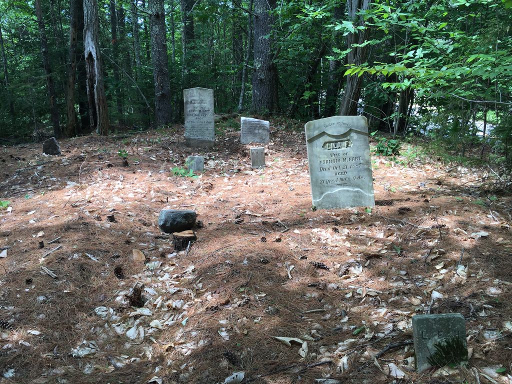
| Description | : | This cemetery is on the southeast corner of Bush Road and Brownfield Road. It is thickly overgrown with trees and only one stone (Lila F. Hart) is standing. Another stone (Mary J. Hart) is leaning against a tree and the stone for Henry M. Hart is disintegrating. Footstones remain in place for all three burials. |
frequently asked questions (FAQ):
-
Where is Frank Hart Cemetery?
Frank Hart Cemetery is located at Eaton Center, Carroll County ,New Hampshire ,USA.
-
Frank Hart Cemetery cemetery's updated grave count on graveviews.com?
0 memorials
-
Where are the coordinates of the Frank Hart Cemetery?
Latitude: 43.9145100
Longitude: -71.0039600
Nearby Cemetories:
1. Thurston-Meserve Cemetery
Eaton, Carroll County, USA
Coordinate: 43.9105100, -71.0027800
2. George Hart Cemetery
Eaton Center, Carroll County, USA
Coordinate: 43.9161600, -70.9950900
3. Gray Gravesite
Eaton Center, Carroll County, USA
Coordinate: 43.9227780, -71.0058330
4. Perkins Cemetery
Eaton, Carroll County, USA
Coordinate: 43.9115300, -71.0160000
5. Hatch Perkins Cemetery
Eaton Center, Carroll County, USA
Coordinate: 43.9181000, -71.0170000
6. Kenneson Cemetery
Eaton, Carroll County, USA
Coordinate: 43.9014700, -70.9997600
7. Joseph Meserve Cemetery
Brownfield, Oxford County, USA
Coordinate: 43.9104300, -70.9854200
8. Dennett Cemetery
Brownfield, Oxford County, USA
Coordinate: 43.9289700, -70.9931000
9. Thompson-Stuart Cemetery
Eaton, Carroll County, USA
Coordinate: 43.9221000, -71.0274000
10. Linscott Cemetery
Brownfield, Oxford County, USA
Coordinate: 43.8984500, -70.9886100
11. Garland Cemetery
Eaton, Carroll County, USA
Coordinate: 43.9111500, -71.0320300
12. Littlefield-Bean Cemetery
Eaton Center, Carroll County, USA
Coordinate: 43.9205560, -71.0372220
13. Flood Cemetery
Eaton Center, Carroll County, USA
Coordinate: 43.8988890, -71.0333330
14. Cole Cemetery
Brownfield, Oxford County, USA
Coordinate: 43.8956000, -70.9768700
15. Greenlaw Cemetery
Brownfield, Oxford County, USA
Coordinate: 43.9263992, -70.9677963
16. Ward-Stuart Cemetery
Eaton, Carroll County, USA
Coordinate: 43.8995300, -71.0391100
17. Brown-Johnson Cemetery
Brownfield, Oxford County, USA
Coordinate: 43.9163710, -70.9617450
18. Walker-Rounds Cemetery
Brownfield, Oxford County, USA
Coordinate: 43.8909100, -70.9765200
19. Sawyer-Drew Cemetery
Eaton Center, Carroll County, USA
Coordinate: 43.9022200, -71.0453300
20. Fernald Cemetery
Eaton, Carroll County, USA
Coordinate: 43.8825600, -71.0159200
21. McCartee Cemetery
Porter, Oxford County, USA
Coordinate: 43.8844430, -70.9770440
22. Bean-West Cemetery
Wentworth Location, Coos County, USA
Coordinate: 43.9472220, -71.0280560
23. Nathaniel Hill Cemetery
Brownfield, Oxford County, USA
Coordinate: 43.8926100, -70.9615000
24. Binford Cemetery
Brownfield, Oxford County, USA
Coordinate: 43.8936250, -70.9597380