
| Memorials | : | 0 |
| Location | : | Brownfield, Oxford County, USA |
| Coordinate | : | 43.8926100, -70.9615000 |
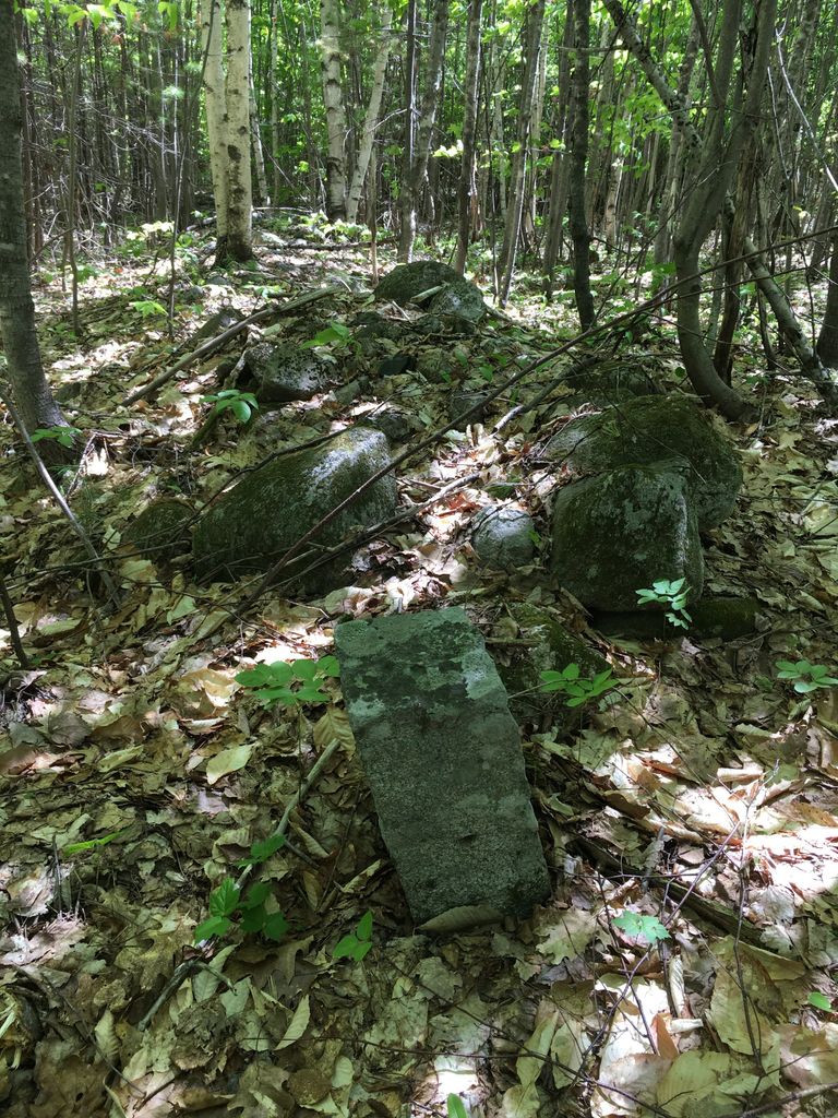
| Description | : | From its intersection with Old County Road, drive west on Phen Hill Road 0.2 miles. On the south (left) side of the road before a gated driveway are granite posts. Many or all of the occupants of this cemetery were moved to Pine Grove. Remaining are three split granite posts, the SE one is standing and the two north ones (by the edge of the road) are lying down. There are at least five grave depressions. |
frequently asked questions (FAQ):
-
Where is Nathaniel Hill Cemetery?
Nathaniel Hill Cemetery is located at Brownfield, Oxford County ,Maine ,USA.
-
Nathaniel Hill Cemetery cemetery's updated grave count on graveviews.com?
0 memorials
-
Where are the coordinates of the Nathaniel Hill Cemetery?
Latitude: 43.8926100
Longitude: -70.9615000
Nearby Cemetories:
1. Binford Cemetery
Brownfield, Oxford County, USA
Coordinate: 43.8936250, -70.9597380
2. Walker-Rounds Cemetery
Brownfield, Oxford County, USA
Coordinate: 43.8909100, -70.9765200
3. Cole Cemetery
Brownfield, Oxford County, USA
Coordinate: 43.8956000, -70.9768700
4. McCartee Cemetery
Porter, Oxford County, USA
Coordinate: 43.8844430, -70.9770440
5. Blake Cemetery
Brownfield, Oxford County, USA
Coordinate: 43.9063988, -70.9514008
6. Quint Cemetery
Brownfield, Oxford County, USA
Coordinate: 43.8984700, -70.9408400
7. Stanley Cemetery
Porter, Oxford County, USA
Coordinate: 43.8761200, -70.9606900
8. Ricker Cemetery
Brownfield, Oxford County, USA
Coordinate: 43.9061540, -70.9425500
9. Johnson Cemetery
Brownfield, Oxford County, USA
Coordinate: 43.8880600, -70.9355600
10. Linscott Cemetery
Brownfield, Oxford County, USA
Coordinate: 43.8984500, -70.9886100
11. Brown-Johnson Cemetery
Brownfield, Oxford County, USA
Coordinate: 43.9163710, -70.9617450
12. Joseph Meserve Cemetery
Brownfield, Oxford County, USA
Coordinate: 43.9104300, -70.9854200
13. Kenneson Cemetery
Eaton, Carroll County, USA
Coordinate: 43.9014700, -70.9997600
14. Sargent-Rounds Cemetery
Porter, Oxford County, USA
Coordinate: 43.8794200, -70.9224200
15. Floyd-Pearl Cemetery
Porter, Oxford County, USA
Coordinate: 43.8627500, -70.9427500
16. George Hart Cemetery
Eaton Center, Carroll County, USA
Coordinate: 43.9161600, -70.9950900
17. Greenlaw Cemetery
Brownfield, Oxford County, USA
Coordinate: 43.9263992, -70.9677963
18. Thurston-Meserve Cemetery
Eaton, Carroll County, USA
Coordinate: 43.9105100, -71.0027800
19. Frank Hart Cemetery
Eaton Center, Carroll County, USA
Coordinate: 43.9145100, -71.0039600
20. Porterfield Cemetery
Porterfield, Oxford County, USA
Coordinate: 43.8769700, -70.9130800
21. Merrill Cemetery
Brownfield, Oxford County, USA
Coordinate: 43.9284000, -70.9423100
22. Wentworth-Brown Cemetery
Brownfield, Oxford County, USA
Coordinate: 43.9317200, -70.9555100
23. Fernald Cemetery
Eaton, Carroll County, USA
Coordinate: 43.8825600, -71.0159200
24. Merrow-Gannett Cemetery
Eaton Center, Carroll County, USA
Coordinate: 43.8745200, -71.0153300