
| Memorials | : | 0 |
| Location | : | Tutzing, Landkreis Starnberg, Germany |
| Coordinate | : | 47.8994350, 11.2545720 |
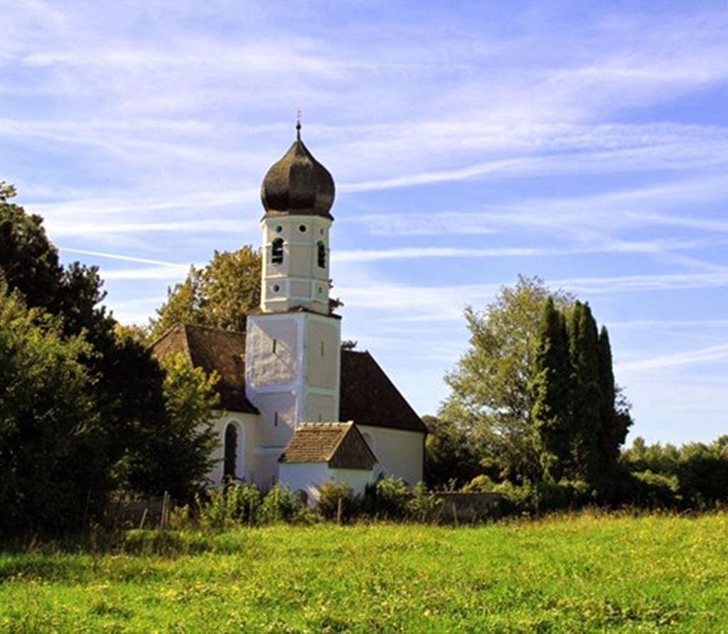
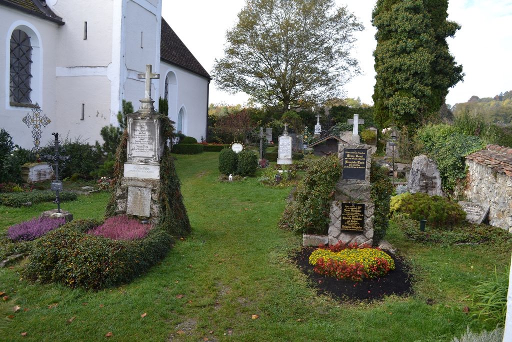
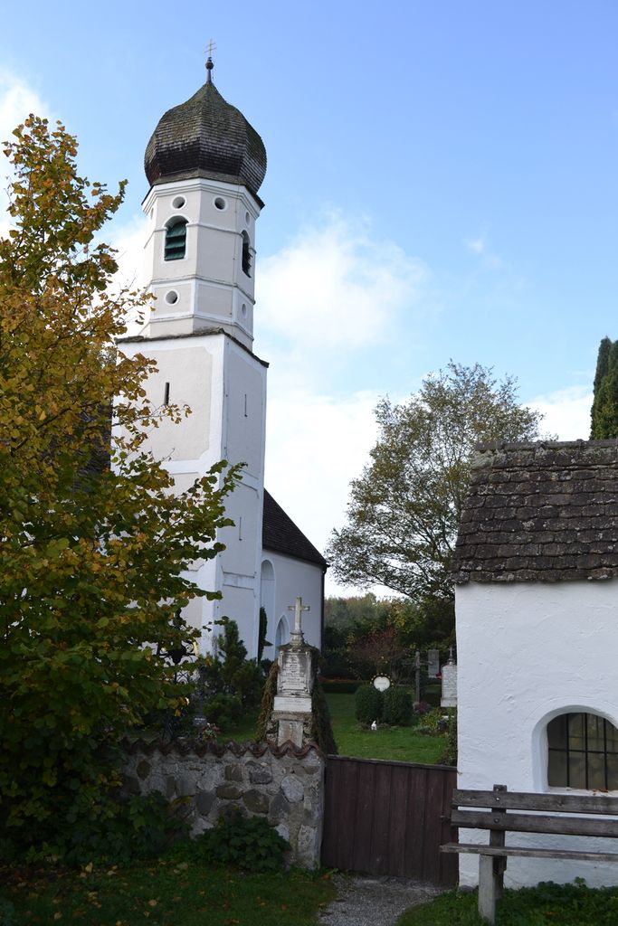
| Description | : | The most remote of all cemeteries in Tutzing. The Ilkahöhe is a 2382-ft-mountain-top just south-east of the Bavarian town of Tutzing. Named after the Bavarian noblewoman Anna Maria "Ilka" von Wrede (1838-1913). To get to the cemetery follow signs to the restaurant "Forsthaus Ilkahöhe". Just before you get to it, there is a small lane going off to the right, leading to this very small cemetery. The small St. Nikolaus-Church is located within the cemetery. Please note that the graves in Germany are not perpetual. After a certain period of repose (20-30 years) the graves are being leveled and re-used. There... Read More |
frequently asked questions (FAQ):
-
Where is Friedhof Ilkahöhe?
Friedhof Ilkahöhe is located at Oberzeismering 10 Tutzing, Landkreis Starnberg ,Bavaria (Bayern) , 82327Germany.
-
Friedhof Ilkahöhe cemetery's updated grave count on graveviews.com?
0 memorials
-
Where are the coordinates of the Friedhof Ilkahöhe?
Latitude: 47.8994350
Longitude: 11.2545720
Nearby Cemetories:
1. Waldfriedhof Tutzing
Tutzing, Landkreis Starnberg, Germany
Coordinate: 47.9123001, 11.2679996
2. Neuer Friedhof Tutzing
Tutzing, Landkreis Starnberg, Germany
Coordinate: 47.9118004, 11.2749996
3. Alter Friedhof
Tutzing, Landkreis Starnberg, Germany
Coordinate: 47.9070015, 11.2810001
4. Diemendorf Friedhof Tutzing
Tutzing, Landkreis Starnberg, Germany
Coordinate: 47.8852196, 11.2217464
5. Hohenried Cemetery
Bernried, Landkreis Weilheim-Schongau, Germany
Coordinate: 47.8770865, 11.2854587
6. Friedhof Bernried
Bernried, Landkreis Weilheim-Schongau, Germany
Coordinate: 47.8661700, 11.2948530
7. Kirchenfriedhof Traubing
Tutzing, Landkreis Starnberg, Germany
Coordinate: 47.9440918, 11.2582502
8. Traubing New Cemetery
Tutzing, Landkreis Starnberg, Germany
Coordinate: 47.9450531, 11.2541561
9. Friedhof Wilzhofen
Wilzhofen, Landkreis Weilheim-Schongau, Germany
Coordinate: 47.8796960, 11.1833250
10. Jüdischer Friedhof Feldafing
Feldafing, Landkreis Starnberg, Germany
Coordinate: 47.9525620, 11.2938840
11. Friedhof Feldafing
Feldafing, Landkreis Starnberg, Germany
Coordinate: 47.9526900, 11.2943300
12. Friedhof Aschering
Pocking, Landkreis Starnberg, Germany
Coordinate: 47.9659958, 11.2569561
13. Neuer Friedhof Pöcking
Pocking, Landkreis Starnberg, Germany
Coordinate: 47.9680099, 11.2987900
14. Alter Friedhof Pöcking
Pocking, Landkreis Starnberg, Germany
Coordinate: 47.9673424, 11.3019686
15. Neuer Friedhof Münsing
Münsing, Landkreis Bad Tölz-Wolfratshausen, Germany
Coordinate: 47.9016105, 11.3668153
16. Kirchhof Mariä Himmelfahrt
Münsing, Landkreis Bad Tölz-Wolfratshausen, Germany
Coordinate: 47.9033796, 11.3669874
17. Gemeindefriedhof Seeshaupt
Seeshaupt, Landkreis Weilheim-Schongau, Germany
Coordinate: 47.8261940, 11.2893100
18. Wittelsbacher Friedhof
Andechs, Landkreis Starnberg, Germany
Coordinate: 47.9742012, 11.1823654
19. Klosterkirche Andechs
Andechs, Landkreis Starnberg, Germany
Coordinate: 47.9744200, 11.1823500
20. St. Bartholomäus Kirchhof Maising
Maising, Landkreis Starnberg, Germany
Coordinate: 47.9861107, 11.2893600
21. Friedhof Aufkirchen
Berg am See, Landkreis Starnberg, Germany
Coordinate: 47.9570190, 11.3611760
22. St. Salvator and Sebastian Churchyard
Weilheim in Oberbayern, Landkreis Weilheim-Schongau, Germany
Coordinate: 47.8413490, 11.1485280
23. St. Heinrich am Starnberger See
Eurasburg, Landkreis Bad Tölz-Wolfratshausen, Germany
Coordinate: 47.8249112, 11.3382042
24. Dorfkirche Herz Jesu Höhenrain
Berg, Landkreis Starnberg, Germany
Coordinate: 47.9313000, 11.3964730