
| Memorials | : | 0 |
| Location | : | Bernried, Landkreis Weilheim-Schongau, Germany |
| Coordinate | : | 47.8770865, 11.2854587 |
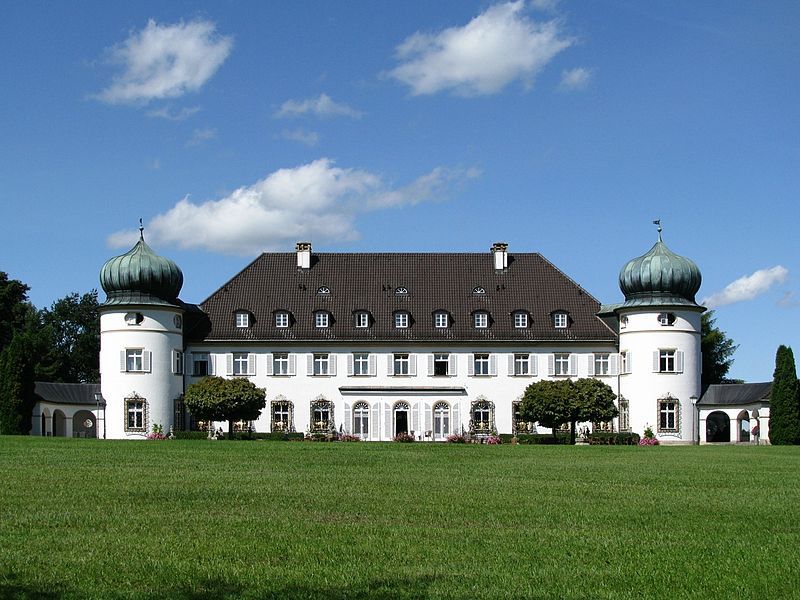
| Description | : | The current site of Schloss Höhenried in Bernried was founded in 1914 (Hofgrund Bernried, Gut Adelsried) and 1927 (Gut Höhenried) from the St. Louis, MO, USA - born co-heiress of the Anheuser-Busch brewery, Wilhelmina Busch, and her first husband, Eduard Scharrer from Stuttgart. The couple Busch-Scharrer initially bought the Postvilla in Bernried and enjoyed great social prestige. After August Scharrer suddenly died in 1932, Wilhelmina Busch married her physician, Carl Borchard, in 1933, whom she divorced a few years later. In 1937, she fulfilled her big dream of building a castle on the grounds. As early as February 1938, the topping-out... Read More |
frequently asked questions (FAQ):
-
Where is Hohenried Cemetery?
Hohenried Cemetery is located at Bernried, Landkreis Weilheim-Schongau ,Bavaria (Bayern) ,Germany.
-
Hohenried Cemetery cemetery's updated grave count on graveviews.com?
0 memorials
-
Where are the coordinates of the Hohenried Cemetery?
Latitude: 47.8770865
Longitude: 11.2854587
Nearby Cemetories:
1. Friedhof Bernried
Bernried, Landkreis Weilheim-Schongau, Germany
Coordinate: 47.8661700, 11.2948530
2. Alter Friedhof
Tutzing, Landkreis Starnberg, Germany
Coordinate: 47.9070015, 11.2810001
3. Friedhof Ilkahöhe
Tutzing, Landkreis Starnberg, Germany
Coordinate: 47.8994350, 11.2545720
4. Neuer Friedhof Tutzing
Tutzing, Landkreis Starnberg, Germany
Coordinate: 47.9118004, 11.2749996
5. Waldfriedhof Tutzing
Tutzing, Landkreis Starnberg, Germany
Coordinate: 47.9123001, 11.2679996
6. Diemendorf Friedhof Tutzing
Tutzing, Landkreis Starnberg, Germany
Coordinate: 47.8852196, 11.2217464
7. Gemeindefriedhof Seeshaupt
Seeshaupt, Landkreis Weilheim-Schongau, Germany
Coordinate: 47.8261940, 11.2893100
8. Neuer Friedhof Münsing
Münsing, Landkreis Bad Tölz-Wolfratshausen, Germany
Coordinate: 47.9016105, 11.3668153
9. Kirchhof Mariä Himmelfahrt
Münsing, Landkreis Bad Tölz-Wolfratshausen, Germany
Coordinate: 47.9033796, 11.3669874
10. St. Heinrich am Starnberger See
Eurasburg, Landkreis Bad Tölz-Wolfratshausen, Germany
Coordinate: 47.8249112, 11.3382042
11. Friedhof Wilzhofen
Wilzhofen, Landkreis Weilheim-Schongau, Germany
Coordinate: 47.8796960, 11.1833250
12. Kirchenfriedhof Traubing
Tutzing, Landkreis Starnberg, Germany
Coordinate: 47.9440918, 11.2582502
13. Traubing New Cemetery
Tutzing, Landkreis Starnberg, Germany
Coordinate: 47.9450531, 11.2541561
14. Jüdischer Friedhof Feldafing
Feldafing, Landkreis Starnberg, Germany
Coordinate: 47.9525620, 11.2938840
15. Friedhof Feldafing
Feldafing, Landkreis Starnberg, Germany
Coordinate: 47.9526900, 11.2943300
16. Alter Friedhof Pöcking
Pocking, Landkreis Starnberg, Germany
Coordinate: 47.9673424, 11.3019686
17. Friedhof Aschering
Pocking, Landkreis Starnberg, Germany
Coordinate: 47.9659958, 11.2569561
18. Neuer Friedhof Pöcking
Pocking, Landkreis Starnberg, Germany
Coordinate: 47.9680099, 11.2987900
19. Dorfkirche Herz Jesu Höhenrain
Berg, Landkreis Starnberg, Germany
Coordinate: 47.9313000, 11.3964730
20. Friedhof Aufkirchen
Berg am See, Landkreis Starnberg, Germany
Coordinate: 47.9570190, 11.3611760
21. St. Salvator and Sebastian Churchyard
Weilheim in Oberbayern, Landkreis Weilheim-Schongau, Germany
Coordinate: 47.8413490, 11.1485280
22. Friedhof Beuerberg
Beuerberg, Landkreis Bad Tölz-Wolfratshausen, Germany
Coordinate: 47.8275684, 11.4142709
23. Friedhof Nantwein
Wolfratshausen, Landkreis Bad Tölz-Wolfratshausen, Germany
Coordinate: 47.9148931, 11.4345117
24. St. Bartholomäus Kirchhof Maising
Maising, Landkreis Starnberg, Germany
Coordinate: 47.9861107, 11.2893600