
| Memorials | : | 0 |
| Location | : | Maising, Landkreis Starnberg, Germany |
| Coordinate | : | 47.9861107, 11.2893600 |
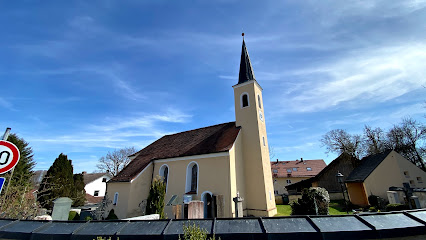
| Description | : | Maising is a small village in Upper-Bavaria (Oberbayern), with about 300 inhabitants. Since 1976 it belongs to the municipality of Pöcking, which is in the district of Starnberg in Bavaria in Germany and consists of the following villages: - Aschering - Maising - Niederpöcking - Seewiesen - Pöcking - Possenhofen On a small elevation in Maising there is the old church yard, surrounding St. Bartholomew Church. Please note that the graves in Germany are not perpetual. After a certain period of repose (20-30 years) the graves are being leveled and re-used. There is no toxic embalming being done in Germany, so the... Read More |
frequently asked questions (FAQ):
-
Where is St. Bartholomäus Kirchhof Maising?
St. Bartholomäus Kirchhof Maising is located at Maising, Landkreis Starnberg ,Bavaria (Bayern) ,Germany.
-
St. Bartholomäus Kirchhof Maising cemetery's updated grave count on graveviews.com?
0 memorials
-
Where are the coordinates of the St. Bartholomäus Kirchhof Maising?
Latitude: 47.9861107
Longitude: 11.2893600
Nearby Cemetories:
1. Friedhof Perchting
Starnberg, Landkreis Starnberg, Germany
Coordinate: 48.0003777, 11.2748775
2. Neuer Friedhof Pöcking
Pocking, Landkreis Starnberg, Germany
Coordinate: 47.9680099, 11.2987900
3. Alter Friedhof Pöcking
Pocking, Landkreis Starnberg, Germany
Coordinate: 47.9673424, 11.3019686
4. Mausoleum Söcking
Starnberg, Landkreis Starnberg, Germany
Coordinate: 48.0026436, 11.3202034
5. Friedhof Söcking
Starnberg, Landkreis Starnberg, Germany
Coordinate: 48.0042229, 11.3223982
6. Friedhof Aschering
Pocking, Landkreis Starnberg, Germany
Coordinate: 47.9659958, 11.2569561
7. Friedhof Feldafing
Feldafing, Landkreis Starnberg, Germany
Coordinate: 47.9526900, 11.2943300
8. Jüdischer Friedhof Feldafing
Feldafing, Landkreis Starnberg, Germany
Coordinate: 47.9525620, 11.2938840
9. Starnberg-St. Josefs Kirche
Starnberg, Landkreis Starnberg, Germany
Coordinate: 47.9977130, 11.3382250
10. Friedhof Hanfelderstrasse
Starnberg, Landkreis Starnberg, Germany
Coordinate: 48.0041100, 11.3400000
11. Kirchenfriedhof Traubing
Tutzing, Landkreis Starnberg, Germany
Coordinate: 47.9440918, 11.2582502
12. Starnberg-Waldfriedhof
Starnberg, Landkreis Starnberg, Germany
Coordinate: 48.0146800, 11.3453700
13. Traubing New Cemetery
Tutzing, Landkreis Starnberg, Germany
Coordinate: 47.9450531, 11.2541561
14. Sankt Valentin Dorfkirche
Starnberg, Landkreis Starnberg, Germany
Coordinate: 47.9987640, 11.3646330
15. Gemeindefriedhof Starnberg - Percha
Starnberg, Landkreis Starnberg, Germany
Coordinate: 48.0004616, 11.3668032
16. Friedhof Gut Rieden. Starnberg
Starnberg, Landkreis Starnberg, Germany
Coordinate: 48.0248642, 11.3478146
17. Friedhof Aufkirchen
Berg am See, Landkreis Starnberg, Germany
Coordinate: 47.9570190, 11.3611760
18. Friedhof Hausen an der Dreifaltigkeitskriche
Gauting, Landkreis Starnberg, Germany
Coordinate: 48.0432190, 11.3306130
19. Friedhof Oberbrunn
Gauting, Landkreis Starnberg, Germany
Coordinate: 48.0502420, 11.3159280
20. Friedhof Leutstetten
Starnberg, Landkreis Starnberg, Germany
Coordinate: 48.0291634, 11.3668804
21. St. Alto Kirchhof
Starnberg, Landkreis Starnberg, Germany
Coordinate: 48.0291040, 11.3669780
22. Friedhof Widdersberg
Widdersberg, Landkreis Starnberg, Germany
Coordinate: 48.0205990, 11.1983390
23. Klosterkirche Andechs
Andechs, Landkreis Starnberg, Germany
Coordinate: 47.9744200, 11.1823500
24. Wittelsbacher Friedhof
Andechs, Landkreis Starnberg, Germany
Coordinate: 47.9742012, 11.1823654