
| Memorials | : | 0 |
| Location | : | High Wycombe, Wycombe District, England |
| Coordinate | : | 51.6282800, -0.7428870 |
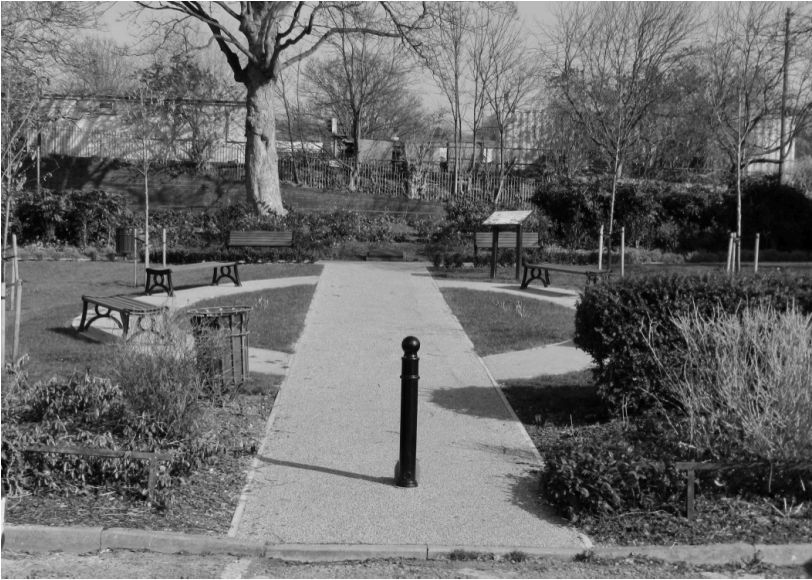
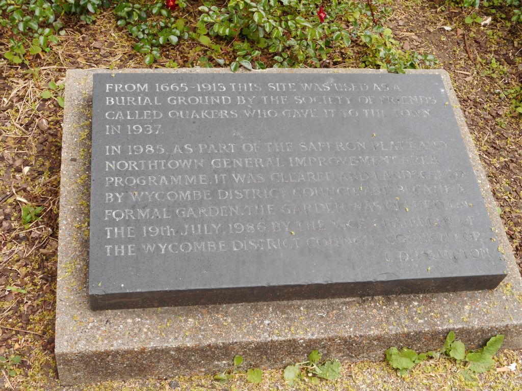
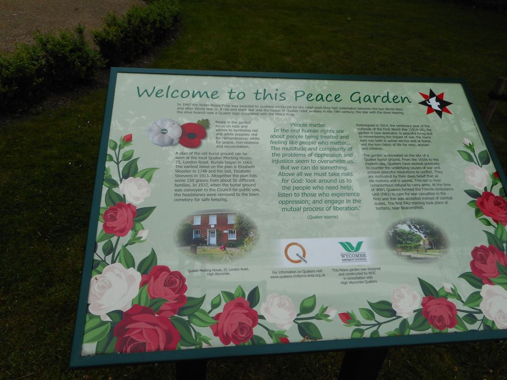
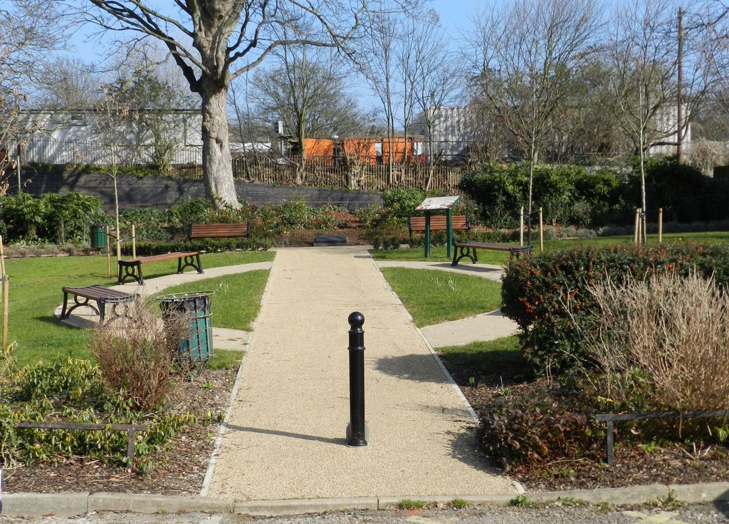
| Description | : | Friends Burial Ground at High Wycombe is no longer in use and since 2014 has been transformed into a Peace Garden. The original burial ground was contained within a walled precinct measuring roughly 92ft East to West by 100ft. North to South. It contained the remains of 147 Friends buried between 1748 and 1913. The burial ground consisted of 45 18th Century graves, 100 19th Century graves and two 20th Century graves, with 3 whose dates are unknown. There are 53 male graves, 92 female graves and 2 unknown children’s graves. The earliest recorded grave is that of Elizabeth Woster... Read More |
frequently asked questions (FAQ):
-
Where is High Wycombe Friends Burial Ground?
High Wycombe Friends Burial Ground is located at Station Road High Wycombe, Wycombe District ,Buckinghamshire , HP13 6ADEngland.
-
High Wycombe Friends Burial Ground cemetery's updated grave count on graveviews.com?
0 memorials
-
Where are the coordinates of the High Wycombe Friends Burial Ground?
Latitude: 51.6282800
Longitude: -0.7428870
Nearby Cemetories:
1. All Saints Churchyard
High Wycombe, Wycombe District, England
Coordinate: 51.6298810, -0.7507090
2. High Wycombe Cemetery
High Wycombe, Wycombe District, England
Coordinate: 51.6383160, -0.7432510
3. Cock Lane Cemetery
High Wycombe, Wycombe District, England
Coordinate: 51.6322236, -0.7045250
4. St. Michael and All Angels Churchyard
Hughenden, Wycombe District, England
Coordinate: 51.6518960, -0.7522470
5. Holy Trinity Churchyard
Hazlemere, Wycombe District, England
Coordinate: 51.6492680, -0.7168260
6. St Margaret Churchyard
Tylers Green, Wycombe District, England
Coordinate: 51.6353110, -0.6960490
7. Four Ashes Garden of Rest
Hughenden, Wycombe District, England
Coordinate: 51.6614724, -0.7389121
8. Altona Road Cemetery
Chepping Wycombe, Wycombe District, England
Coordinate: 51.6102200, -0.6938200
9. Atlona Road Cemetery
Loudwater, Wycombe District, England
Coordinate: 51.6101490, -0.6932680
10. Cryers Hill Methodist Cemetery
Cryers Hill, Wycombe District, England
Coordinate: 51.6646790, -0.7349370
11. Fern Lane Cemetery
Little Marlow, Wycombe District, England
Coordinate: 51.5887390, -0.7273880
12. Holy Trinity Churchyard
Penn, Chiltern District, England
Coordinate: 51.6310240, -0.6774510
13. Dashwood Mausoleum
West Wycombe, Wycombe District, England
Coordinate: 51.6471210, -0.8047420
14. St. Lawrence Churchyard
West Wycombe, Wycombe District, England
Coordinate: 51.6479900, -0.8060200
15. St. John the Baptist Churchyard
Little Marlow, Wycombe District, England
Coordinate: 51.5826450, -0.7398600
16. Christ Church Churchyard
Holmer Green, Chiltern District, England
Coordinate: 51.6680370, -0.6914780
17. St. Botolph Churchyard
Bradenham, Wycombe District, England
Coordinate: 51.6668380, -0.8041850
18. Marlow Cemetery
Marlow, Wycombe District, England
Coordinate: 51.5773094, -0.7761266
19. Holy Trinity Churchyard
Penn Street, Chiltern District, England
Coordinate: 51.6571500, -0.6661430
20. Holtspur Cemetery
Beaconsfield, South Bucks District, England
Coordinate: 51.5964280, -0.6663890
21. Holy Trinity Churchyard
Marlow, Wycombe District, England
Coordinate: 51.5750000, -0.7768000
22. St. Paul's Churchyard
Wooburn, Wycombe District, England
Coordinate: 51.5816640, -0.6886330
23. Little Kingshill Baptist Churchyard
High Wycombe, Wycombe District, England
Coordinate: 51.6821322, -0.7087242
24. Wooburn & Bourne End Cemetery
Wooburn, Wycombe District, England
Coordinate: 51.5795260, -0.6919400