
| Memorials | : | 5 |
| Location | : | Point Reyes Station, Marin County, USA |
| Coordinate | : | 38.0933000, -122.9311300 |
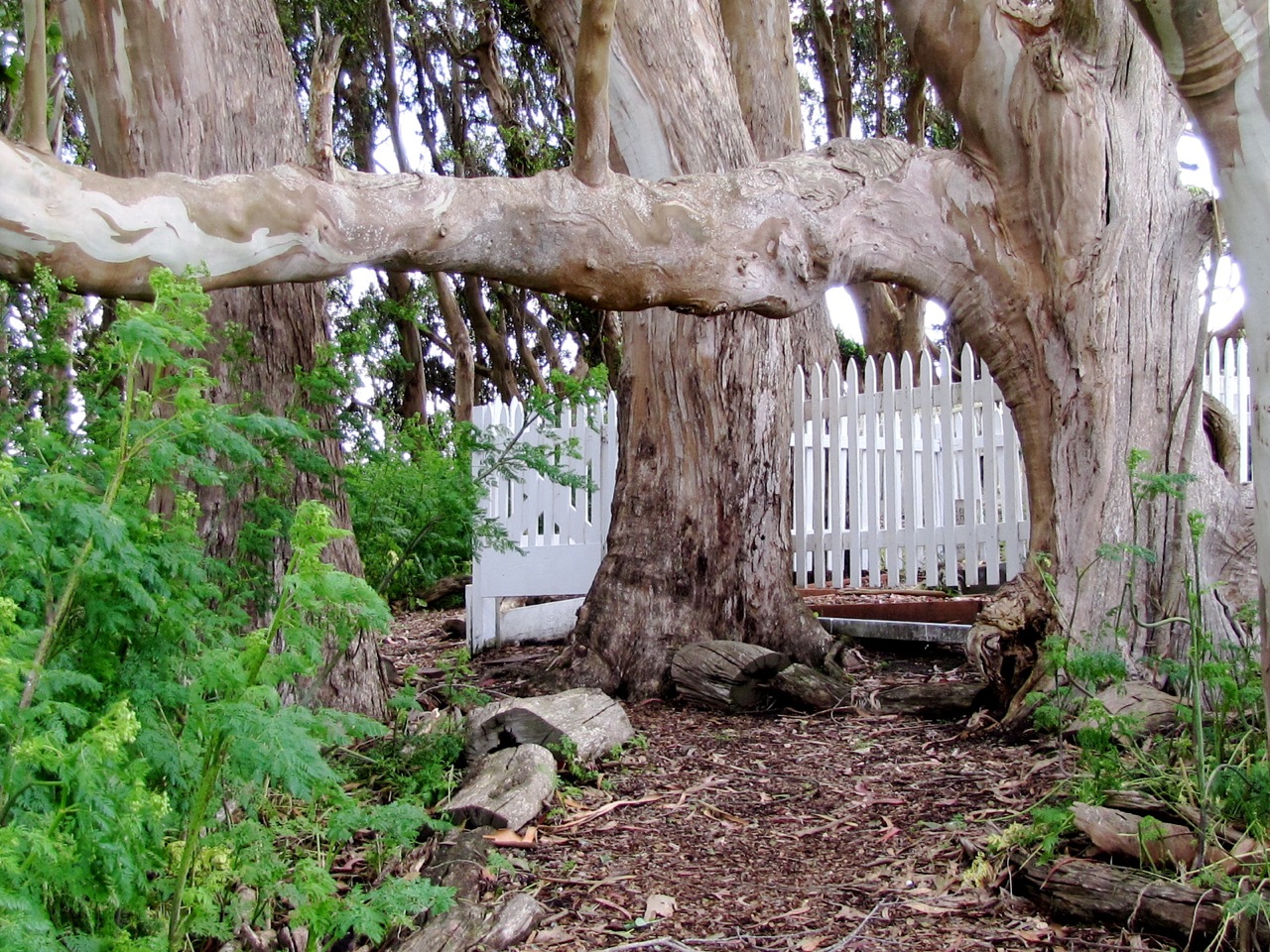
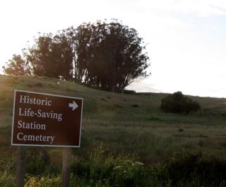
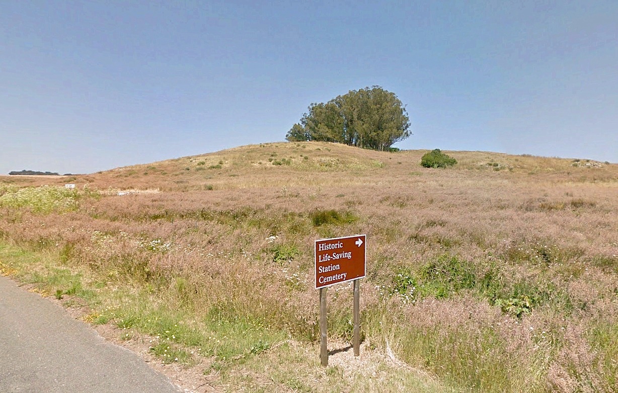
| Description | : | -Begin at the headquarters for the Point Reyes National Seashore -Bear Valley Visitor Center, 76 Bear Valley Road, Point Reyes Station, CA 94956 -head north 0.2 mile to Bear Valley Road -Turn left at stop sign and follow Bear Valley Road 1.75 miles northwest to Sir Francis Drake Boulevard. -Turn left at stop sign and follow Sir Francis Drake Boulevard 8.55 miles west. (Follow the road signs for “Point Reyes Lighthouse” ) -Just past the “Oyster Farm” turnoff, just west of Schooner Creek you will see the sign for "Historic Life-saving Station Cemetery" -Turn right and... Read More |
frequently asked questions (FAQ):
-
Where is Historic Life-Saving Service and G Ranch Cemetery?
Historic Life-Saving Service and G Ranch Cemetery is located at Sir Francis Drake Boulevard Point Reyes Station, Marin County ,California , 94956USA.
-
Historic Life-Saving Service and G Ranch Cemetery cemetery's updated grave count on graveviews.com?
5 memorials
-
Where are the coordinates of the Historic Life-Saving Service and G Ranch Cemetery?
Latitude: 38.0933000
Longitude: -122.9311300
Nearby Cemetories:
1. Saint Columbas Church Cemetery
Inverness, Marin County, USA
Coordinate: 38.0998250, -122.8576210
2. Miwok Cemetery
Reynolds, Marin County, USA
Coordinate: 38.1491420, -122.8852400
3. Olema Cemetery
Olema, Marin County, USA
Coordinate: 38.0313988, -122.7789001
4. Tomales Presbyterian Cemetery
Tomales, Marin County, USA
Coordinate: 38.2455215, -122.9075089
5. Tomales Catholic Cemetery
Tomales, Marin County, USA
Coordinate: 38.2482300, -122.9142500
6. Taylor Cemetery
Lagunitas, Marin County, USA
Coordinate: 38.0272580, -122.7346590
7. Two Rock Presbyterian Church Cemetery
Two Rock, Sonoma County, USA
Coordinate: 38.2570000, -122.7795029
8. Bloomfield Cemetery
Bloomfield, Sonoma County, USA
Coordinate: 38.3135986, -122.8583984
9. Bodega Bay Cemetery
Bodega Bay, Sonoma County, USA
Coordinate: 38.3172740, -123.0257990
10. Calvary Cemetery
Bodega, Sonoma County, USA
Coordinate: 38.3414993, -122.9749985
11. Bolinas Cemetery
Bolinas, Marin County, USA
Coordinate: 37.9212600, -122.6938900
12. Saint Mary Magdalene Catholic Church Cemetery
Bolinas, Marin County, USA
Coordinate: 37.9212570, -122.6938858
13. Saint Theresa of Avila Church Cemetery
Bodega, Sonoma County, USA
Coordinate: 38.3461342, -122.9723663
14. Liberty Cemetery
Petaluma, Sonoma County, USA
Coordinate: 38.2781990, -122.7055500
15. Oak Hill Cemetery
Petaluma, Sonoma County, USA
Coordinate: 38.2365130, -122.6509010
16. Calvary Catholic Cemetery
Petaluma, Sonoma County, USA
Coordinate: 38.2449000, -122.6493400
17. My Pets Cemetery
Petaluma, Sonoma County, USA
Coordinate: 38.2472000, -122.6506000
18. Cypress Hill Memorial Park
Petaluma, Sonoma County, USA
Coordinate: 38.2472000, -122.6505966
19. Pioneer Memorial Cemetery
Novato, Marin County, USA
Coordinate: 38.1132532, -122.5902599
20. B'nai Israel Cemetery
Petaluma, Sonoma County, USA
Coordinate: 38.2454700, -122.6490000
21. Canfield Cemetery
Sebastopol, Sonoma County, USA
Coordinate: 38.3512430, -122.8147040
22. Jasper O'Farrell Ranch Cemetery
Freestone, Sonoma County, USA
Coordinate: 38.3758300, -122.9090300
23. Macedonia Methodist Episcopal Church Cemetery
Sebastopol, Sonoma County, USA
Coordinate: 38.3594860, -122.7727270
24. Marin County Farm Cemetery
Marin County, USA
Coordinate: 38.0285500, -122.5652530