
| Memorials | : | 0 |
| Location | : | Åsnes kommune, Norway |
| Coordinate | : | 60.5510204, 12.0178858 |
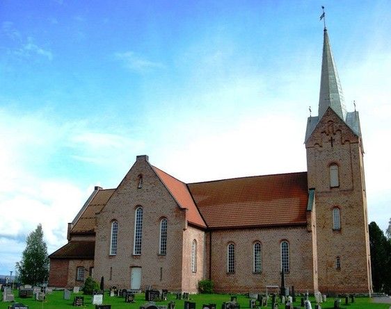
| Description | : | The church is made of bricks, built in the 1860's, on the west side of the river " Glomma ". The church is placed at the cemetery/churchyard. Åsnes kommune is in a region of Hedmark fylke, also known as " Solør ". |
frequently asked questions (FAQ):
-
Where is Hof Church Cemetery?
Hof Church Cemetery is located at Åsnes kommune ,Hedmark fylke ,Norway.
-
Hof Church Cemetery cemetery's updated grave count on graveviews.com?
0 memorials
-
Where are the coordinates of the Hof Church Cemetery?
Latitude: 60.5510204
Longitude: 12.0178858
Nearby Cemetories:
1. Åsnes kirkegård
Kjellmyra, Åsnes kommune, Norway
Coordinate: 60.6100000, 11.9762940
2. Grue Cemetery
Kirkenaer i Solor, Grue kommune, Norway
Coordinate: 60.4492200, 12.0531800
3. Våler Cemetery
Våler i Solor, Våler kommune, Norway
Coordinate: 60.6726000, 11.8354300
4. Hof Finnskog
Hof, Åsnes kommune, Norway
Coordinate: 60.5767000, 12.3380000
5. Mo Churchyard
Sand, Nord-Odal kommune, Norway
Coordinate: 60.4288290, 11.6350790
6. Nordre Gravplass Åsnes Finnskog
Velta, Åsnes kommune, Norway
Coordinate: 60.7082200, 12.3621400
7. Grue Finnskog Cemetery
Svullrya, Grue kommune, Norway
Coordinate: 60.4182840, 12.4055750
8. Åsnes Finnskog
Velta, Åsnes kommune, Norway
Coordinate: 60.7039000, 12.3796000
9. Brandval Parish Cemetery
Brandval, Kongsvinger kommune, Norway
Coordinate: 60.3160760, 12.0144770
10. Sand Church
Sand, Nord-Odal kommune, Norway
Coordinate: 60.3906480, 11.5431170
11. Södra Finnskoga kyrkogård
Medskogen, Torsby kommun, Sweden
Coordinate: 60.7003060, 12.5784720
12. Heradsbygd kirkegård
Heradsbygd, Elverum kommune, Norway
Coordinate: 60.8228625, 11.6344067
13. Vinger Cemetery
Kongsvinger, Kongsvinger kommune, Norway
Coordinate: 60.1947560, 12.0096070
14. Vallset kirkegård
Stange, Stange kommune, Norway
Coordinate: 60.7012600, 11.3286000
15. Tangen kirkegård
Stange, Stange kommune, Norway
Coordinate: 60.6167300, 11.2653600
16. Strandlykkja cemetery
Strandlykkja, Stange kommune, Norway
Coordinate: 60.5138100, 11.2472333
17. Ullern
Ulleren, Sør-Odal kommune, Norway
Coordinate: 60.2128180, 11.6351600
18. Elverum Churchyard
Elverum, Elverum kommune, Norway
Coordinate: 60.8776090, 11.5655730
19. Langset Parish
Minnesund, Eidsvoll kommune, Norway
Coordinate: 60.4073113, 11.2427180
20. Sørskogbygda Kirke Cemetery
Elverum, Elverum kommune, Norway
Coordinate: 60.9427210, 11.7735460
21. Romedal Kirkegård
Romedal, Stange kommune, Norway
Coordinate: 60.7517000, 11.2614400
22. Feiring Kirke
Feiring, Eidsvoll kommune, Norway
Coordinate: 60.4847000, 11.1495000
23. Løten Kirke Cemetery
Loten, Løten kommune, Norway
Coordinate: 60.8268950, 11.3172070
24. Eidsvoll Church Cemetery
Eidsvoll, Eidsvoll kommune, Norway
Coordinate: 60.3234700, 11.2434500