
| Memorials | : | 0 |
| Location | : | Sand, Nord-Odal kommune, Norway |
| Coordinate | : | 60.4288290, 11.6350790 |
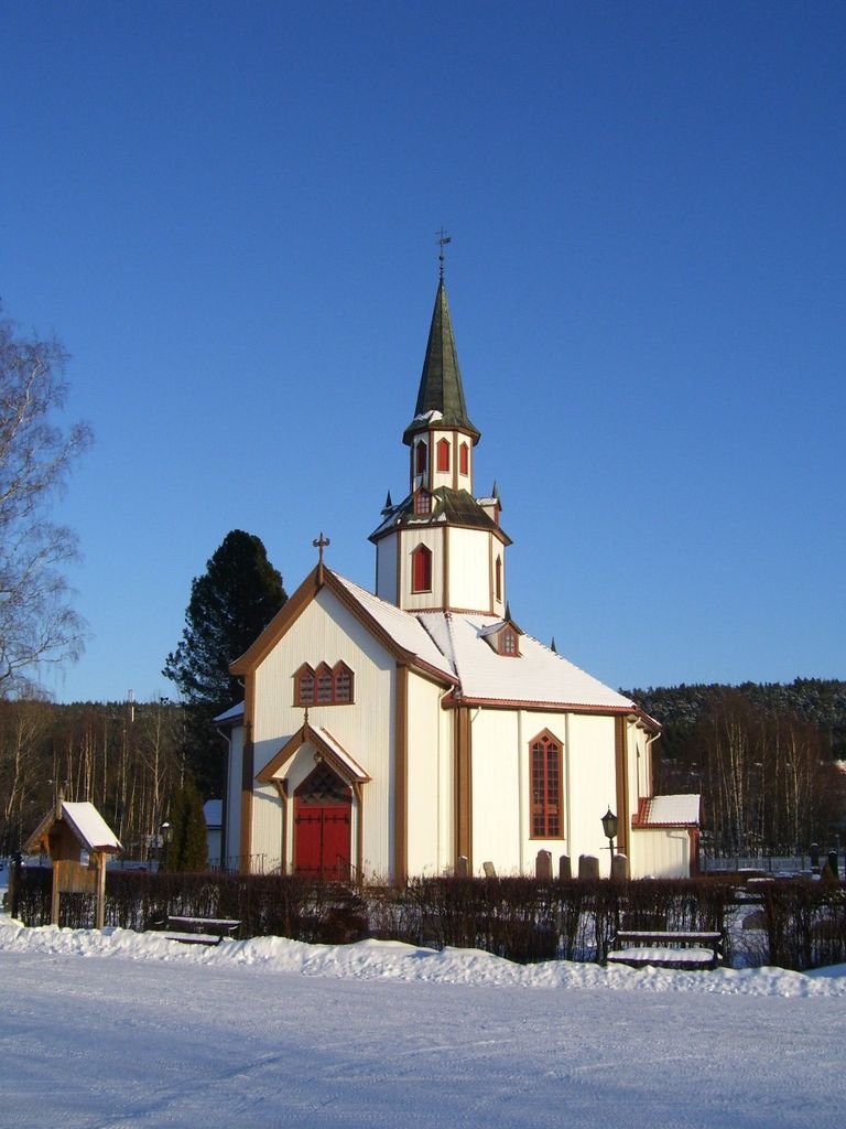
| Description | : | Mo Church is an octagonal wooden church from 1863 in North Odal in Hedmark, Norway. The church is the parish church for Mo. Mo Church was inaugurated on 6 December 1864 by Bishop Halvor Folkestad. It is built on a drawing by the architect Christian H. Grosch. Grosch has also designed the Tangen Church in Stange,Hedmark and Skaare church in Haugesund. The structure is of wood and has 500 seats. The altarpiece is from 1880 and is a copy of Adolph Tidemand painting "Baptism of Christ." The original is in the Trinity Church in Oslo. Twin brothers Gudbrand and Bernt... Read More |
frequently asked questions (FAQ):
-
Where is Mo Churchyard?
Mo Churchyard is located at Harald Stormoens veg Sand, Nord-Odal kommune ,Hedmark fylke , 2133Norway.
-
Mo Churchyard cemetery's updated grave count on graveviews.com?
0 memorials
-
Where are the coordinates of the Mo Churchyard?
Latitude: 60.4288290
Longitude: 11.6350790
Nearby Cemetories:
1. Sand Church
Sand, Nord-Odal kommune, Norway
Coordinate: 60.3906480, 11.5431170
2. Langset Parish
Minnesund, Eidsvoll kommune, Norway
Coordinate: 60.4073113, 11.2427180
3. Grue Cemetery
Kirkenaer i Solor, Grue kommune, Norway
Coordinate: 60.4492200, 12.0531800
4. Strandlykkja cemetery
Strandlykkja, Stange kommune, Norway
Coordinate: 60.5138100, 11.2472333
5. Ullern
Ulleren, Sør-Odal kommune, Norway
Coordinate: 60.2128180, 11.6351600
6. Brandval Parish Cemetery
Brandval, Kongsvinger kommune, Norway
Coordinate: 60.3160760, 12.0144770
7. Eidsvoll Church Cemetery
Eidsvoll, Eidsvoll kommune, Norway
Coordinate: 60.3234700, 11.2434500
8. Hof Church Cemetery
Åsnes kommune, Norway
Coordinate: 60.5510204, 12.0178858
9. Feiring Kirke
Feiring, Eidsvoll kommune, Norway
Coordinate: 60.4847000, 11.1495000
10. Åsnes kirkegård
Kjellmyra, Åsnes kommune, Norway
Coordinate: 60.6100000, 11.9762940
11. Tangen kirkegård
Stange, Stange kommune, Norway
Coordinate: 60.6167300, 11.2653600
12. Våler Cemetery
Våler i Solor, Våler kommune, Norway
Coordinate: 60.6726000, 11.8354300
13. Raaholt Cemetery
Raholt, Eidsvoll kommune, Norway
Coordinate: 60.2751000, 11.1790000
14. Nes Kirke
Vormsund, Nes kommune, Norway
Coordinate: 60.1619024, 11.4500313
15. Vinger Cemetery
Kongsvinger, Kongsvinger kommune, Norway
Coordinate: 60.1947560, 12.0096070
16. Stensgård Kirkegård
Nannestad kommune, Norway
Coordinate: 60.2775540, 11.0882430
17. Vallset kirkegård
Stange, Stange kommune, Norway
Coordinate: 60.7012600, 11.3286000
18. Aarnes Cemetery
Årnes, Nes kommune, Norway
Coordinate: 60.1251790, 11.4719160
19. Bjørke Kirke
Nannestad kommune, Norway
Coordinate: 60.2342490, 11.0121679
20. Romedal Kirkegård
Romedal, Stange kommune, Norway
Coordinate: 60.7517000, 11.2614400
21. Stange Church Cemetery
Stange, Stange kommune, Norway
Coordinate: 60.7098210, 11.1373780
22. Hof Finnskog
Hof, Åsnes kommune, Norway
Coordinate: 60.5767000, 12.3380000
23. Nannestad
Nannestad kommune, Norway
Coordinate: 60.2144610, 11.0051450
24. Grue Finnskog Cemetery
Svullrya, Grue kommune, Norway
Coordinate: 60.4182840, 12.4055750