
| Memorials | : | 1 |
| Location | : | Yearsley, Hambleton District, England |
| Coordinate | : | 54.1619100, -1.1052300 |
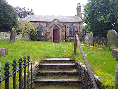
| Description | : | Holy Trinity Church was historically a chapelry in the parish of Coxwold. The Archbishop of York consecrated a newly-built chapel on 6 Sept 1853. Burial registers for Coxwold parish dating from 1583 to 1859 have been deposited with the Borthwick Institute for Archives, University of York, Heslington, York, YO10 5DD. |
frequently asked questions (FAQ):
-
Where is Holy Trinity Churchyard?
Holy Trinity Churchyard is located at Well Lane Yearsley, Hambleton District ,North Yorkshire , YO61 4SLEngland.
-
Holy Trinity Churchyard cemetery's updated grave count on graveviews.com?
1 memorials
-
Where are the coordinates of the Holy Trinity Churchyard?
Latitude: 54.1619100
Longitude: -1.1052300
Nearby Cemetories:
1. All Saints Churchyard
Brandsby, Hambleton District, England
Coordinate: 54.1397200, -1.0853500
2. Holy Cross Churchyard
Gilling East, Ryedale District, England
Coordinate: 54.1841290, -1.0580460
3. Gilling New Churchyard
Gilling East, Ryedale District, England
Coordinate: 54.1856070, -1.0559535
4. St Hilda Churchyard
Ampleforth, Ryedale District, England
Coordinate: 54.2000630, -1.1075590
5. Our Lady & St Benedict RC Churchyard
Ampleforth, Ryedale District, England
Coordinate: 54.2009700, -1.1055400
6. St Cuthbert Churchyard
Crayke, Hambleton District, England
Coordinate: 54.1285740, -1.1441370
7. Ampleforth Friends Burial Ground
Ampleforth, Ryedale District, England
Coordinate: 54.2023420, -1.1213330
8. Ampleforth Abbey
Ampleforth, Ryedale District, England
Coordinate: 54.2019630, -1.0838000
9. Ampleforth Abbey - Monk's Wood
Ampleforth, Ryedale District, England
Coordinate: 54.2028689, -1.0841344
10. Newburgh Priory
Coxwold, Hambleton District, England
Coordinate: 54.1811000, -1.1731000
11. St Oswald Churchyard
Oswaldkirk, Ryedale District, England
Coordinate: 54.2022340, -1.0495510
12. Byland Abbey
Coxwold, Hambleton District, England
Coordinate: 54.2034480, -1.1589660
13. St. Michael's Churchyard
Coxwold, Hambleton District, England
Coordinate: 54.1878500, -1.1847120
14. St Peter Churchyard
Dalby, Hambleton District, England
Coordinate: 54.1329290, -1.0262920
15. St Mary Churchyard
Marton-on-the Forest, Hambleton District, England
Coordinate: 54.1064900, -1.0807800
16. St Martin Churchyard
Whenby, Hambleton District, England
Coordinate: 54.1202600, -1.0363700
17. St. Nicholas Churchyard
Stillington, Hambleton District, England
Coordinate: 54.1029710, -1.1098920
18. St George the Martyr Churchyard
Scackleton, Ryedale District, England
Coordinate: 54.1457520, -1.0066750
19. St Nicholas Churchyard
Husthwaite, Hambleton District, England
Coordinate: 54.1692000, -1.2075900
20. Husthwaite Cemetery
Husthwaite, Hambleton District, England
Coordinate: 54.1684400, -1.2142000
21. St John the Baptist and All Saints Churchyard
Easingwold, Hambleton District, England
Coordinate: 54.1235320, -1.1973170
22. St Leonard Churchyard
Farlington, Hambleton District, England
Coordinate: 54.0999600, -1.0614900
23. Stonegrave Minster Churchyard
Stonegrave, Ryedale District, England
Coordinate: 54.1925011, -0.9966000
24. Hovingham Cemetery
Hovingham, Ryedale District, England
Coordinate: 54.1753500, -0.9808900