
| Memorials | : | 5 |
| Location | : | Ratcliffe-on-Soar, Rushcliffe Borough, England |
| Coordinate | : | 52.8553380, -1.2665520 |
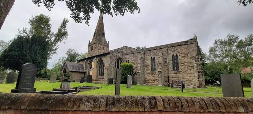
| Description | : | Holy Trinity Church, Ratcliffe-on-Soar is a 13th century parish church in Ratcliffe-on-Soar. Major restoration work was carried out in 1886, paid for by Earl Howe at a cost of £830. It is part of an informal grouping of five churches that are known collectively as "The 453 Churches" as they straddle the A453. |
frequently asked questions (FAQ):
-
Where is Holy Trinity Churchyard?
Holy Trinity Churchyard is located at Ratcliffe-on-Soar, Rushcliffe Borough ,Nottinghamshire , NG11 0EAEngland.
-
Holy Trinity Churchyard cemetery's updated grave count on graveviews.com?
5 memorials
-
Where are the coordinates of the Holy Trinity Churchyard?
Latitude: 52.8553380
Longitude: -1.2665520


Nearby Cemetories:
1. Saint Andrew's Churchyard
Kegworth, North West Leicestershire District, England
Coordinate: 52.8358160, -1.2780850
2. Kegworth Cemetery
Kegworth, North West Leicestershire District, England
Coordinate: 52.8332680, -1.2816790
3. All Saints Churchyard
Thrumpton, Rushcliffe Borough, England
Coordinate: 52.8755100, -1.2440800
4. Saint Nicholas Churchyard
Lockington, North West Leicestershire District, England
Coordinate: 52.8468883, -1.3063910
5. St. Nicholas' Churchyard
Lockington, North West Leicestershire District, England
Coordinate: 52.8468300, -1.3065600
6. All Saints Churchyard
Sawley, Erewash Borough, England
Coordinate: 52.8776016, -1.2995000
7. Sawley Baptist Churchyard
Sawley, Erewash Borough, England
Coordinate: 52.8799410, -1.3009980
8. Marle Pit Hill Cemetery
Sutton Bonington, Rushcliffe Borough, England
Coordinate: 52.8241820, -1.2525970
9. St. Michael's Churchyard
Sutton Bonington, Rushcliffe Borough, England
Coordinate: 52.8240654, -1.2529907
10. St. Anne's Churchyard
Sutton Bonington, Rushcliffe Borough, England
Coordinate: 52.8206200, -1.2485400
11. St Helena Churchyard
West Leake, Rushcliffe Borough, England
Coordinate: 52.8330920, -1.2171267
12. Castle Donington Cemetery
Castle Donington, North West Leicestershire District, England
Coordinate: 52.8431520, -1.3307570
13. Quaker Burial Ground
Castle Donington, North West Leicestershire District, England
Coordinate: 52.8435100, -1.3328900
14. St. Laurence Churchyard
Long Eaton, Erewash Borough, England
Coordinate: 52.8985000, -1.2710000
15. Long Eaton Cemetery
Long Eaton, Erewash Borough, England
Coordinate: 52.8986580, -1.2785390
16. St. Edward King & Martyr Churchyard
Castle Donington, North West Leicestershire District, England
Coordinate: 52.8417000, -1.3383000
17. All Saints Churchyard
Long Whatton, North West Leicestershire District, England
Coordinate: 52.8052840, -1.2859690
18. St. Michael Churchyard
Breaston, Erewash Borough, England
Coordinate: 52.8969700, -1.3176200
19. St James Churchyard
Shardlow, South Derbyshire District, England
Coordinate: 52.8686280, -1.3508150
20. St Mary's Church Attenborough
Beeston, Broxtowe Borough, England
Coordinate: 52.9039568, -1.2302235
21. St Michael & All Angels Churchyard
Long Whatton, North West Leicestershire District, England
Coordinate: 52.8164170, -1.3282730
22. Greenhill Rise Cemetery
Hathern, Charnwood Borough, England
Coordinate: 52.7990180, -1.2576160
23. St. Peters & St. Paul Cemetery
Hathern, Charnwood Borough, England
Coordinate: 52.7970560, -1.2558040
24. Chilwell Cemetery
Nottingham, Nottingham Unitary Authority, England
Coordinate: 52.9164070, -1.2430800