| Memorials | : | 0 |
| Location | : | Castle Donington, North West Leicestershire District, England |
| Coordinate | : | 52.8435100, -1.3328900 |
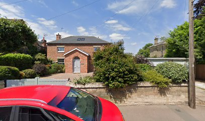
| Description | : | A little west of Castle Donington Cemetery, the burial ground forms the back garden of the former Quaker Meeting House which dates from 1829, though burials predate this. The building had ceased to be used for worship by the 1940s, with gravestones laid flat to form a pathway through the grounds. The house and garden are now private property. |
frequently asked questions (FAQ):
-
Where is Quaker Burial Ground?
Quaker Burial Ground is located at Quaker House, 51 Barroon Castle Donington, North West Leicestershire District ,Leicestershire , DE74 2PFEngland.
-
Quaker Burial Ground cemetery's updated grave count on graveviews.com?
0 memorials
-
Where are the coordinates of the Quaker Burial Ground?
Latitude: 52.8435100
Longitude: -1.3328900
Nearby Cemetories:
1. Castle Donington Cemetery
Castle Donington, North West Leicestershire District, England
Coordinate: 52.8431520, -1.3307570
2. St. Edward King & Martyr Churchyard
Castle Donington, North West Leicestershire District, England
Coordinate: 52.8417000, -1.3383000
3. St. Nicholas' Churchyard
Lockington, North West Leicestershire District, England
Coordinate: 52.8468300, -1.3065600
4. Saint Nicholas Churchyard
Lockington, North West Leicestershire District, England
Coordinate: 52.8468883, -1.3063910
5. St Michael & All Angels Churchyard
Long Whatton, North West Leicestershire District, England
Coordinate: 52.8164170, -1.3282730
6. St James Churchyard
Shardlow, South Derbyshire District, England
Coordinate: 52.8686280, -1.3508150
7. All Saints Churchyard
Isley Walton, North West Leicestershire District, England
Coordinate: 52.8211576, -1.3710891
8. Kegworth Cemetery
Kegworth, North West Leicestershire District, England
Coordinate: 52.8332680, -1.2816790
9. Saint Andrew's Churchyard
Kegworth, North West Leicestershire District, England
Coordinate: 52.8358160, -1.2780850
10. All Saints Churchyard
Aston on Trent, South Derbyshire District, England
Coordinate: 52.8606040, -1.3866670
11. Moor Lane
Aston on Trent, South Derbyshire District, England
Coordinate: 52.8651600, -1.3826900
12. All Saints Churchyard
Sawley, Erewash Borough, England
Coordinate: 52.8776016, -1.2995000
13. Sawley Baptist Churchyard
Sawley, Erewash Borough, England
Coordinate: 52.8799410, -1.3009980
14. Holy Trinity Churchyard
Ratcliffe-on-Soar, Rushcliffe Borough, England
Coordinate: 52.8553380, -1.2665520
15. St Mary the Virgin Churchyard
Weston on Trent, South Derbyshire District, England
Coordinate: 52.8444900, -1.4105600
16. All Saints Churchyard
Long Whatton, North West Leicestershire District, England
Coordinate: 52.8052840, -1.2859690
17. St. Michael's Churchyard
Sutton Bonington, Rushcliffe Borough, England
Coordinate: 52.8240654, -1.2529907
18. Marle Pit Hill Cemetery
Sutton Bonington, Rushcliffe Borough, England
Coordinate: 52.8241820, -1.2525970
19. St. Michael Churchyard
Breaston, Erewash Borough, England
Coordinate: 52.8969700, -1.3176200
20. Breedon Priory
Breedon on the Hill, North West Leicestershire District, England
Coordinate: 52.8060120, -1.3999600
21. St. Anne's Churchyard
Sutton Bonington, Rushcliffe Borough, England
Coordinate: 52.8206200, -1.2485400
22. Melbourne Cemetery
Melbourne, South Derbyshire District, England
Coordinate: 52.8291310, -1.4271470
23. St Michael & St Mary Old Churchyard
Melbourne, South Derbyshire District, England
Coordinate: 52.8221000, -1.4240900
24. St Michael with St Mary Church
Melbourne, South Derbyshire District, England
Coordinate: 52.8210800, -1.4242900

