
| Memorials | : | 0 |
| Location | : | Whitesburg, Carroll County, USA |
| Coordinate | : | 33.5139008, -84.9116974 |
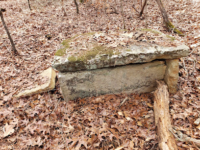
| Description | : | From Whitesburg, cross the railroad tracks at Jones Mill Road. Go 1.5 miles to the intersection of Wellington Mill Road and turn left. Go 0.3 mile on Wellington Mill Road and the cemetery is on the north side (right) of the road in a wooded area. In addition to these marked graves, there could possibly be as many as 75 graves marked only with rocks or evidenced by sunken areas. The area is densely wooded and covered with a heavy accumulation of leaves and fallen tree branches. |
frequently asked questions (FAQ):
-
Where is Jones Mill Cemetery?
Jones Mill Cemetery is located at Whitesburg, Carroll County ,Georgia ,USA.
-
Jones Mill Cemetery cemetery's updated grave count on graveviews.com?
0 memorials
-
Where are the coordinates of the Jones Mill Cemetery?
Latitude: 33.5139008
Longitude: -84.9116974
Nearby Cemetories:
1. Ayers Cemetery
Whitesburg, Carroll County, USA
Coordinate: 33.5029340, -84.9100470
2. Mount Calvary Cemetery
Carroll County, USA
Coordinate: 33.5085983, -84.9246979
3. Corinth Baptist Church Cemetery
Whitesburg, Carroll County, USA
Coordinate: 33.5231018, -84.9233017
4. Whitesburg Cemetery
Whitesburg, Carroll County, USA
Coordinate: 33.5005989, -84.9180984
5. Banning Church of God Cemetery
Whitesburg, Carroll County, USA
Coordinate: 33.5088340, -84.9296410
6. Antioch Primitive Baptist Church Cemetery
Banning, Carroll County, USA
Coordinate: 33.5181007, -84.9321976
7. Buyers Cemetery
Whitesburg, Carroll County, USA
Coordinate: 33.5079750, -84.8897370
8. Mount Avery Missionary Baptist Memory Gardens
Whitesburg, Carroll County, USA
Coordinate: 33.5317001, -84.8966980
9. Dillard Cemetery
Whitesburg, Carroll County, USA
Coordinate: 33.4920640, -84.9213980
10. Mount Avery Missionary Baptist Church Cemetery
Whitesburg, Carroll County, USA
Coordinate: 33.4867220, -84.9074080
11. Taylor Cemetery
Whitesburg, Carroll County, USA
Coordinate: 33.4875450, -84.8988030
12. Culpepper Cemetery
Whitesburg, Carroll County, USA
Coordinate: 33.4870620, -84.9352600
13. Jones-Watson Cemetery
Whitesburg, Carroll County, USA
Coordinate: 33.5186780, -84.8694710
14. Saint Paul Methodist Church Cemetery
Whitesburg, Carroll County, USA
Coordinate: 33.5503006, -84.9094009
15. Antioch Baptist Church Cemetery
Whitesburg, Carroll County, USA
Coordinate: 33.5228190, -84.8674190
16. Summerlin - Adams Cemetery
Whitesburg, Carroll County, USA
Coordinate: 33.5028620, -84.8676250
17. Sparks Cemetery
Dingler Crossroads, Carroll County, USA
Coordinate: 33.5429840, -84.9445500
18. Driver-Boon-Bearden Family Cemetery
Carrollton, Carroll County, USA
Coordinate: 33.5353710, -84.9556820
19. Head Family Cemetery
Whitesburg, Carroll County, USA
Coordinate: 33.5410910, -84.8566390
20. Avery Cemetery
Whitesburg, Carroll County, USA
Coordinate: 33.5280340, -84.8473910
21. Rotherwood First Congregational Methodist Church C
Lowell, Carroll County, USA
Coordinate: 33.4709000, -84.9554730
22. Lang-Moore Cemetery
Roscoe, Coweta County, USA
Coordinate: 33.5039500, -84.8448900
23. Consolation Baptist Church Cemetery
Whitesburg, Carroll County, USA
Coordinate: 33.5731010, -84.9171982
24. Gray Family Cemetery
Carrollton, Carroll County, USA
Coordinate: 33.5025160, -84.9822250