
| Memorials | : | 0 |
| Location | : | Barneveld Municipality, Netherlands |
| Coordinate | : | 52.1409500, 5.5780800 |
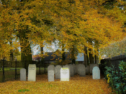
| Description | : | Land for cemetery on the Kallenbroekerweg, adjacent to the public cemetery of Barneveld, was purchased by the community in 1858. In use 1858-1922. The cemetery is now owned by the Amersfoort community but is maintained by the city of Barneveld. The cemetery's headstones were restored in 2000. |
frequently asked questions (FAQ):
-
Where is Joodse Begraafplaats?
Joodse Begraafplaats is located at Kallenbroekerweg Barneveld Municipality ,Gelderland , 3771 CKNetherlands.
-
Joodse Begraafplaats cemetery's updated grave count on graveviews.com?
0 memorials
-
Where are the coordinates of the Joodse Begraafplaats?
Latitude: 52.1409500
Longitude: 5.5780800
Nearby Cemetories:
1. Barneveld Begraafplaats De Plantage
Barneveld, Barneveld Municipality, Netherlands
Coordinate: 52.1353200, 5.5718900
2. Barneveld Concentration Camp
Barneveld, Barneveld Municipality, Netherlands
Coordinate: 52.1427050, 5.5912750
3. Voorthuizen General Cemetery
Voorthuizen, Barneveld Municipality, Netherlands
Coordinate: 52.1939400, 5.6077300
4. Hoevelaken Begraafplaats
Hoevelaken, Nijkerk Municipality, Netherlands
Coordinate: 52.1785700, 5.4530100
5. Joodse Begraafplaats Nijkerkerveen
Nijkerkerveen, Nijkerk Municipality, Netherlands
Coordinate: 52.2064170, 5.4693330
6. Nijkerk Begraafplaats
Nijkerk, Nijkerk Municipality, Netherlands
Coordinate: 52.2188900, 5.4803400
7. Grote Kerk
Nijkerk, Nijkerk Municipality, Netherlands
Coordinate: 52.2228390, 5.4830470
8. De Munnikenhof Begraafplaats
Veenendaal, Veenendaal Municipality, Netherlands
Coordinate: 52.0339200, 5.5475300
9. Paasberg Mausoleum
Ede, Ede Municipality, Netherlands
Coordinate: 52.0437800, 5.6786500
10. Oode Joodse begraafplaats Bloemendalsestraat
Amersfoort Municipality, Netherlands
Coordinate: 52.1601500, 5.3896600
11. Putten General Cemetery
Putten, Putten Municipality, Netherlands
Coordinate: 52.2576500, 5.6038900
12. Woudenberg General Cemetery
Woudenberg, Woudenberg Municipality, Netherlands
Coordinate: 52.0823400, 5.4079800
13. Amersfoort Roman Catholic Cemetery
Amersfoort, Amersfoort Municipality, Netherlands
Coordinate: 52.1509300, 5.3818700
14. Rusthof Cemetery
Oud-Leusden, Leusden Municipality, Netherlands
Coordinate: 52.1288100, 5.3758500
15. Algemene Begraafplaats Oud Leusden
Oud-Leusden, Leusden Municipality, Netherlands
Coordinate: 52.1310600, 5.3721800
16. Otterlo General Cemetery
Otterlo, Ede Municipality, Netherlands
Coordinate: 52.1033100, 5.7767900
17. Joodse Begraafplaats
Veenendaal Municipality, Netherlands
Coordinate: 52.0135700, 5.5543300
18. Joodse Begraafplaats Soesterweg
Amersfoort, Amersfoort Municipality, Netherlands
Coordinate: 52.1570050, 5.3699520
19. Amersfoort Soesterkwartier Cemetery
Amersfoort, Amersfoort Municipality, Netherlands
Coordinate: 52.1575100, 5.3689900
20. Amersfoort Concentration Camp
Leusden Municipality, Netherlands
Coordinate: 52.1322500, 5.3652800
21. Katholieke Begraafplaats
Maarn, Utrechtse Heuvelrug Municipality, Netherlands
Coordinate: 52.0673700, 5.3790400
22. Amerongen Holleweg General Cemetery
Amerongen, Utrechtse Heuvelrug Municipality, Netherlands
Coordinate: 52.0030000, 5.4665700
23. Bennekom Algemene Begraafplaats
Bennekom, Ede Municipality, Netherlands
Coordinate: 51.9983500, 5.6775500
24. Oude Begraafplaats
Amerongen, Utrechtse Heuvelrug Municipality, Netherlands
Coordinate: 51.9989844, 5.4677837