
| Memorials | : | 0 |
| Location | : | Stanley Crossroads, Escambia County, USA |
| Coordinate | : | 31.1427994, -87.3974991 |
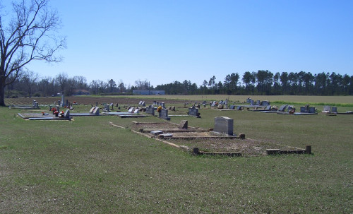
| Description | : | The Miller cemetery is completely surrounded by open farm land of cotton and soybean, but easily accessible on hard ground. At the east and west ends stand a small grove of giant pecan trees. The land was given by John Lewis Miller as a place of rest for his family and friends. The location is near Little Rock, Alabama, Escambia County T-2-N, R-7-E, Section 18. When driving from Interstate-65 north bound, exit at #69 and turn southeast toward Flomaton. At approximately 1/4 miles turn right onto county road 17 (also known as Old Atmore Road). ... Read More |
frequently asked questions (FAQ):
-
Where is Miller Cemetery?
Miller Cemetery is located at Stanley Crossroads, Escambia County ,Alabama ,USA.
-
Miller Cemetery cemetery's updated grave count on graveviews.com?
0 memorials
-
Where are the coordinates of the Miller Cemetery?
Latitude: 31.1427994
Longitude: -87.3974991
Nearby Cemetories:
1. Pleasant Grove Church Cemetery
Escambia County, USA
Coordinate: 31.1578007, -87.4105988
2. Little Rock Church Assemblies of the Lord Jesus Ch
Little Rock, Escambia County, USA
Coordinate: 31.1182995, -87.3893967
3. Conway Cemetery
Escambia County, USA
Coordinate: 31.1148120, -87.4136960
4. Magnolia Cemetery
Escambia County, USA
Coordinate: 31.1536007, -87.3388977
5. Moyeville Church Cemetery
Stanley Crossroads, Escambia County, USA
Coordinate: 31.1072006, -87.3435974
6. Fountain Correctional Facility Cemetery
Atmore, Escambia County, USA
Coordinate: 31.1519170, -87.4688370
7. Robinsonville Church Cemetery
Atmore, Escambia County, USA
Coordinate: 31.0713997, -87.4238968
8. Emmons Cemetery West
Escambia County, USA
Coordinate: 31.1644001, -87.3000031
9. Canoe United Methodist Church Cemetery
Robinsonville, Escambia County, USA
Coordinate: 31.0599995, -87.4377975
10. Huxford Indian Cemetery
Escambia County, USA
Coordinate: 31.2237339, -87.4461136
11. New Home Indian Cemetery
Poarch, Escambia County, USA
Coordinate: 31.1101300, -87.4967300
12. Sardis Primitive Baptist Cemetery
Huxford, Escambia County, USA
Coordinate: 31.2245460, -87.4462800
13. Huxford Community of Christ Cemetery
Huxford, Escambia County, USA
Coordinate: 31.2285830, -87.4414300
14. Hammac Cemetery
Escambia County, USA
Coordinate: 31.1154000, -87.2890000
15. Poarch Mission Cemetery
Escambia County, USA
Coordinate: 31.1208000, -87.5124969
16. Huxford Cemetery
Huxford, Escambia County, USA
Coordinate: 31.2175007, -87.4813995
17. Halls Creek Church Cemetery
Escambia County, USA
Coordinate: 31.1219006, -87.2767029
18. Red Oak Missionary Baptist Church Cemetery
Escambia County, USA
Coordinate: 31.1186660, -87.2763130
19. Myrick Family Cemetery
Canoe, Escambia County, USA
Coordinate: 31.0353490, -87.4145650
20. First Baptist Church Cemetery
McCullough, Escambia County, USA
Coordinate: 31.1580390, -87.5262200
21. Poarch Baptist Church Indian Cemetery
Poarch, Escambia County, USA
Coordinate: 31.1209110, -87.5264240
22. Boutwell-Lambeth Cemetery
Flomaton, Escambia County, USA
Coordinate: 31.0701020, -87.2970200
23. Pierce Rabb Cemetery
Atmore, Escambia County, USA
Coordinate: 31.1049060, -87.5223960
24. Bowman Cemetery
Wawbeek, Escambia County, USA
Coordinate: 31.0303000, -87.3681000