
| Memorials | : | 0 |
| Location | : | Robinsonville, Escambia County, USA |
| Coordinate | : | 31.0599995, -87.4377975 |
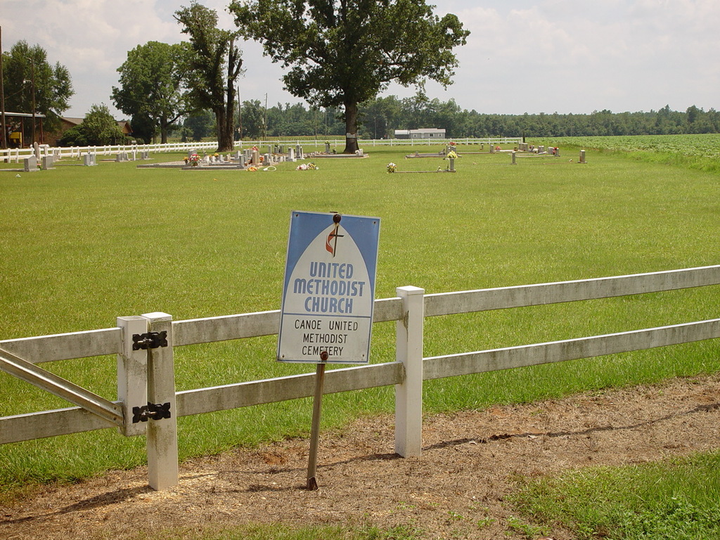
| Description | : | The Canoe United Methodist Church Cemetery is located in Robinsonville, Alabama, approximately one mile west of the Robinsonville Baptist Church, on Fore's Store Road off Escambia County Road 27 (CR-27). This site was to be the location of a Methodist church, but the church was eventually built in the town of Canoe. The land was maintained and developed as a cemetery. Today the cemetery is well kept in a beautiful setting behind a white rail fence amongst large oak and pecan trees. |
frequently asked questions (FAQ):
-
Where is Canoe United Methodist Church Cemetery?
Canoe United Methodist Church Cemetery is located at on Fore's Store Road off Escambia County Road 27 (CR-27) Robinsonville, Escambia County ,Alabama ,USA.
-
Canoe United Methodist Church Cemetery cemetery's updated grave count on graveviews.com?
0 memorials
-
Where are the coordinates of the Canoe United Methodist Church Cemetery?
Latitude: 31.0599995
Longitude: -87.4377975
Nearby Cemetories:
1. Robinsonville Church Cemetery
Atmore, Escambia County, USA
Coordinate: 31.0713997, -87.4238968
2. Myrick Family Cemetery
Canoe, Escambia County, USA
Coordinate: 31.0353490, -87.4145650
3. Canaan Freewill Cemetery
Canoe, Escambia County, USA
Coordinate: 31.0272007, -87.4207993
4. Serenity Gardens Cemetery
Atmore, Escambia County, USA
Coordinate: 31.0244007, -87.4467010
5. Hall Family Cemetery
Atmore, Escambia County, USA
Coordinate: 31.0256004, -87.4191971
6. Lucy Hill Cemetery Complex
Atmore, Escambia County, USA
Coordinate: 31.0413710, -87.4840580
7. Gaines Chapel AME Church Cemetery
Atmore, Escambia County, USA
Coordinate: 31.0294000, -87.4868130
8. Oak Hill Cemetery
Atmore, Escambia County, USA
Coordinate: 31.0414009, -87.4955978
9. Conway Cemetery
Escambia County, USA
Coordinate: 31.1148120, -87.4136960
10. Pine Level Cemetery
Atmore, Escambia County, USA
Coordinate: 31.0465508, -87.5072174
11. Williams Station Cemetery
Escambia County, USA
Coordinate: 31.0227800, -87.4966700
12. Bowman Cemetery
Wawbeek, Escambia County, USA
Coordinate: 31.0303000, -87.3681000
13. New Home Indian Cemetery
Poarch, Escambia County, USA
Coordinate: 31.1101300, -87.4967300
14. Little Rock Church Assemblies of the Lord Jesus Ch
Little Rock, Escambia County, USA
Coordinate: 31.1182995, -87.3893967
15. Davis Cemetery
Freemanville, Escambia County, USA
Coordinate: 31.0726766, -87.5204899
16. Freemanville Church Cemetery
Escambia County, USA
Coordinate: 31.0670260, -87.5216170
17. Mothershed Cemetery
Freemanville, Escambia County, USA
Coordinate: 31.0557900, -87.5318900
18. Sardis Cemetery
Wawbeek, Escambia County, USA
Coordinate: 31.0308304, -87.3452835
19. Pierce Rabb Cemetery
Atmore, Escambia County, USA
Coordinate: 31.1049060, -87.5223960
20. Poarch Mission Cemetery
Escambia County, USA
Coordinate: 31.1208000, -87.5124969
21. Miller Cemetery
Stanley Crossroads, Escambia County, USA
Coordinate: 31.1427994, -87.3974991
22. Godwin Cemetery
Bratt, Escambia County, USA
Coordinate: 30.9683800, -87.4351900
23. Moyeville Church Cemetery
Stanley Crossroads, Escambia County, USA
Coordinate: 31.1072006, -87.3435974
24. Williams Family Cemetery
Atmore, Escambia County, USA
Coordinate: 31.0880020, -87.5424800