
| Memorials | : | 103 |
| Location | : | Friendship, Crockett County, USA |
| Coordinate | : | 35.8955420, -89.2576300 |
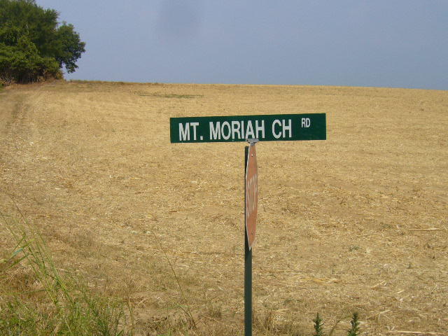
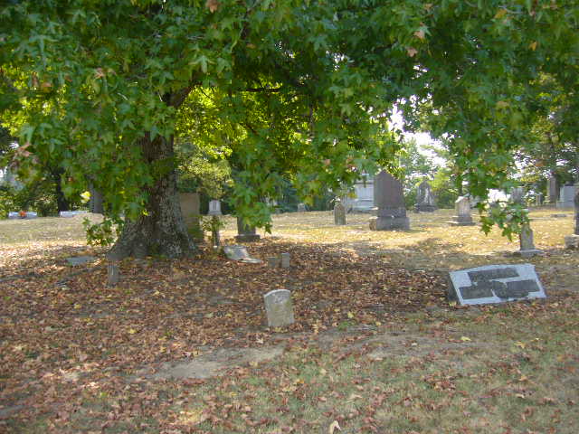
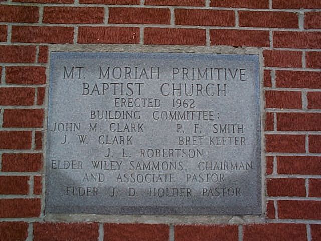
| Description | : | From the intersection of Chestnut Bluff Rd. & US-412, south of Friendship, travel southwest on Chestnut Bluff Rd. for 0.6 mi., just past the intersection with Mt. Moriah Church Rd., to the "Mt. Moriah Primitive Baptist Cemetery", per their newer sign. It is enclosed within a sturdy new metal fence, and adjacent to their old church building; that now has a new name & different congregation. |
frequently asked questions (FAQ):
-
Where is Mount Moriah Cemetery?
Mount Moriah Cemetery is located at 889 Chestnut Bluff Road Friendship, Crockett County ,Tennessee ,USA.
-
Mount Moriah Cemetery cemetery's updated grave count on graveviews.com?
103 memorials
-
Where are the coordinates of the Mount Moriah Cemetery?
Latitude: 35.8955420
Longitude: -89.2576300
Nearby Cemetories:
1. Robertson-Warren Cemetery
Friendship, Crockett County, USA
Coordinate: 35.8830700, -89.2427200
2. Bellevernon Cemetery
Friendship, Crockett County, USA
Coordinate: 35.9135830, -89.2495910
3. Friendship Cemetery
Friendship, Crockett County, USA
Coordinate: 35.9146430, -89.2381450
4. Zion Hill Church Cemetery
Friendship, Dyer County, USA
Coordinate: 35.9095110, -89.2900760
5. Browder Family Cemetery
Broadview, Crockett County, USA
Coordinate: 35.8646890, -89.2623010
6. Hardin Cemetery
Friendship, Dyer County, USA
Coordinate: 35.9243270, -89.2766430
7. Mose M. Thompson Cemetery
Friendship, Dyer County, USA
Coordinate: 35.9243680, -89.2765870
8. Mount Pisgah Cemetery
Friendship, Dyer County, USA
Coordinate: 35.9162470, -89.2901740
9. Nash Cemetery
Dyersburg, Dyer County, USA
Coordinate: 35.9252500, -89.2822230
10. Antioch Cemetery
Friendship, Crockett County, USA
Coordinate: 35.8581090, -89.2577800
11. Bowen Chapel Cemetery
Friendship, Dyer County, USA
Coordinate: 35.9311810, -89.2353720
12. Old Dyer Church Cemetery
Friendship, Crockett County, USA
Coordinate: 35.8844600, -89.2101900
13. Cock and Irvin Cemetery
Hawkinsville, Dyer County, USA
Coordinate: 35.9104430, -89.3046210
14. Mount Zion Cemetery
Friendship, Crockett County, USA
Coordinate: 35.9131950, -89.2032590
15. Edwards Cemetery
Friendship, Crockett County, USA
Coordinate: 35.9314120, -89.2146810
16. Perry Cemetery
Maury Junction, Crockett County, USA
Coordinate: 35.8675600, -89.2051410
17. Staggs Cemetery
Friendship, Dyer County, USA
Coordinate: 35.9397930, -89.2896620
18. Scarborough Cemetery
Broadview, Crockett County, USA
Coordinate: 35.8432570, -89.2546330
19. Deaton Cemetery
Friendship, Crockett County, USA
Coordinate: 35.9350080, -89.2122640
20. Stallcup Family Cemetery
Cross Roads, Dyer County, USA
Coordinate: 35.8980720, -89.3245320
21. Floyds Chapel Cemetery
Broadview, Crockett County, USA
Coordinate: 35.8403860, -89.2592840
22. Hudson Grove Church Cemetery
Crockett Mills, Crockett County, USA
Coordinate: 35.8713410, -89.1956910
23. Siloam Cemetery
Dog Hill, Crockett County, USA
Coordinate: 35.8398940, -89.2832260
24. South Fork Cemetery
Chestnut Bluff, Crockett County, USA
Coordinate: 35.8646420, -89.3206200