
| Memorials | : | 0 |
| Location | : | Carroll County, USA |
| Coordinate | : | 39.5705681, -93.5641022 |
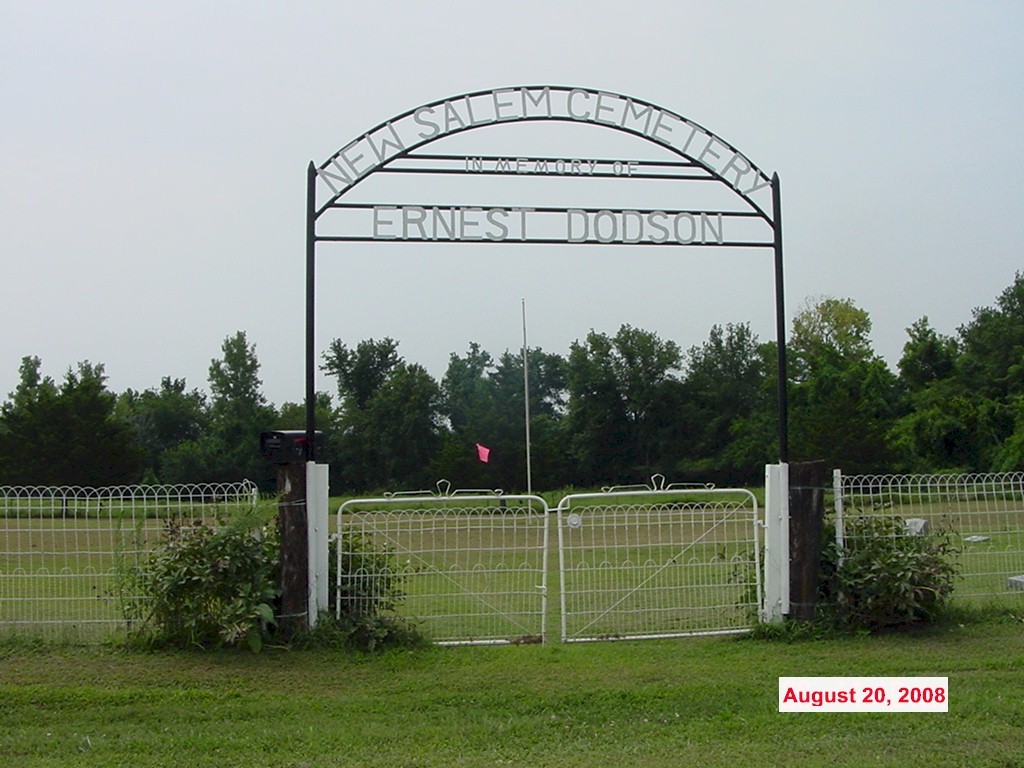
| Description | : | sign reads: "New Salem Cemetery - in Memory of Ernest Dodson" New Salem Church was once apparently located across the road from this cemetery; it was established in 1894 and burned down about 1998 From the intersection of State Hwy Z and CR130 (old CR712) travel west on CR130 7/10 mile. Cemetery is located on the south side of the road From the intersection of State Hwy F and CR130 (old CR712) travel east on CR130 3-8/10 miles. Cemetery is located on the south side of the road |
frequently asked questions (FAQ):
-
Where is New Salem Cemetery?
New Salem Cemetery is located at Carroll County ,Missouri ,USA.
-
New Salem Cemetery cemetery's updated grave count on graveviews.com?
0 memorials
-
Where are the coordinates of the New Salem Cemetery?
Latitude: 39.5705681
Longitude: -93.5641022

Nearby Cemetories:
1. Unnamed Cemetery #5
Carroll County, USA
Coordinate: 39.5480995, -93.5820007
2. Braden Cemetery
Coloma, Carroll County, USA
Coordinate: 39.5393982, -93.5460968
3. Sykes Cemetery
Carroll County, USA
Coordinate: 39.5449000, -93.5993000
4. Coloma Cemetery
Coloma, Carroll County, USA
Coordinate: 39.5342178, -93.5233154
5. Enon Cemetery
Carroll County, USA
Coordinate: 39.5758000, -93.6366000
6. Blue Mound Cemetery
Dawn, Livingston County, USA
Coordinate: 39.6352997, -93.5625000
7. Johnson Cemetery
Carroll County, USA
Coordinate: 39.6136017, -93.4985962
8. Unnamed Cemetery #32
Carroll County, USA
Coordinate: 39.5028992, -93.5487976
9. Marple Cemetery
Carroll County, USA
Coordinate: 39.5014992, -93.5702972
10. Unnamed Cemetery #10
Carroll County, USA
Coordinate: 39.6150017, -93.4850998
11. Glaze Cemetery
Carroll County, USA
Coordinate: 39.4908000, -93.5720000
12. Harris Cemetery
Mandeville, Carroll County, USA
Coordinate: 39.5083680, -93.6314570
13. Gudgel Cemetery
Carroll County, USA
Coordinate: 39.5993996, -93.6660995
14. Powers Cemetery
Carroll County, USA
Coordinate: 39.5990000, -93.4568000
15. Collar Cemetery
Dawn, Livingston County, USA
Coordinate: 39.6345700, -93.6418300
16. Oak Grove Cemetery
Avalon, Livingston County, USA
Coordinate: 39.6505750, -93.5035460
17. Mayberry Cemetery
Livingston County, USA
Coordinate: 39.6506004, -93.5033035
18. Rock Branch Cemetery
Tina, Carroll County, USA
Coordinate: 39.5283012, -93.4569016
19. Unnamed Cemetery #26
Carroll County, USA
Coordinate: 39.4808006, -93.5985031
20. Smith Cemetery
Carroll County, USA
Coordinate: 39.4813995, -93.6205978
21. Hawkins Cemetery
Carroll County, USA
Coordinate: 39.5014000, -93.6569977
22. Ebenezer Cemetery
Bogard, Carroll County, USA
Coordinate: 39.4692001, -93.5691986
23. Van Horn Cemetery
Van Horn Township, Carroll County, USA
Coordinate: 39.4850000, -93.4760000
24. Plymouth Cemetery
Plymouth, Carroll County, USA
Coordinate: 39.6006012, -93.7014008