
| Memorials | : | 42 |
| Location | : | Sugar Tree, Decatur County, USA |
| Coordinate | : | 35.7592360, -88.0661490 |
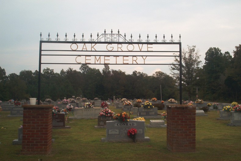
| Description | : | From intersection of Old State Hwy 69 E & US-641, north of Parsons, travel east on Old State Hwy 69 E for 1.0 mi. to the cemetery on the north (left) side of the road, beside the Oak Grove Church building. Oak Grove is a large cemetery in the Cozette Community of northeastern Decatur County. The cemetery is well maintained. The cemetery seems to date from the middle of the nineteenth century. The oldest part is the eastern side of the portion within the access drive loop. There are some fieldstone marked graves and probably are several dozen... Read More |
frequently asked questions (FAQ):
-
Where is Oak Grove Church Cemetery?
Oak Grove Church Cemetery is located at 155 Bohannon Landing Road Sugar Tree, Decatur County ,Tennessee , 38380USA.
-
Oak Grove Church Cemetery cemetery's updated grave count on graveviews.com?
42 memorials
-
Where are the coordinates of the Oak Grove Church Cemetery?
Latitude: 35.7592360
Longitude: -88.0661490
Nearby Cemetories:
1. Bawcum Cemetery
Cozette, Decatur County, USA
Coordinate: 35.7696770, -88.0826580
2. Baker Cemetery
Decatur County, USA
Coordinate: 35.7536011, -88.0369034
3. Hendrix Cemetery
Decatur County, USA
Coordinate: 35.7481003, -88.0391998
4. Hendrix Cemetery
Cozette, Decatur County, USA
Coordinate: 35.7481130, -88.0387250
5. Bawcum Cemetery
Akins Chapel, Decatur County, USA
Coordinate: 35.7823020, -88.0856120
6. Haynes Cemetery
Sugar Tree, Decatur County, USA
Coordinate: 35.7670210, -88.0320540
7. Miller Cemetery
Decatur County, USA
Coordinate: 35.7321990, -88.0489400
8. Suttles Chapel Cemetery
Parsons, Decatur County, USA
Coordinate: 35.7562710, -88.1063310
9. Jeanette Cemetery
Jeannette, Decatur County, USA
Coordinate: 35.7378370, -88.1004330
10. Cheney Cemetery
Sugar Tree, Decatur County, USA
Coordinate: 35.7538986, -88.0177994
11. Lewis Family Cemetery
Jeannette, Decatur County, USA
Coordinate: 35.7422500, -88.1117700
12. Moore Chapel Cemetery
Jeannette, Decatur County, USA
Coordinate: 35.7302250, -88.1059110
13. Walker Cemetery
Decatur County, USA
Coordinate: 35.7153015, -88.0658035
14. Bowman Cemetery
Jeannette, Decatur County, USA
Coordinate: 35.7317350, -88.1147700
15. Hartley Cemetery
Sugar Tree, Decatur County, USA
Coordinate: 35.7896470, -88.0195500
16. Jennings Cemetery
Parsons, Decatur County, USA
Coordinate: 35.7191020, -88.1053980
17. Stills Cemetery
Yellow Springs, Decatur County, USA
Coordinate: 35.7577960, -88.1301680
18. Wilkins Cemetery
Parsons, Decatur County, USA
Coordinate: 35.7051000, -88.0772050
19. Walker Cemetery
Parsons, Decatur County, USA
Coordinate: 35.7120360, -88.1066540
20. Houston Cemetery
Parsons, Decatur County, USA
Coordinate: 35.7037230, -88.0904280
21. Gibson Cemetery
Yellow Springs, Decatur County, USA
Coordinate: 35.7585700, -88.1412850
22. Cheney Cemetery
Parsons, Decatur County, USA
Coordinate: 35.7219840, -88.1262170
23. Lain Cemetery
Sugar Tree, Decatur County, USA
Coordinate: 35.7800640, -87.9925310
24. Cub Creek Hall Cemetery
Parsons, Decatur County, USA
Coordinate: 35.7529410, -88.1492770