
| Memorials | : | 0 |
| Location | : | Latonia Lakes, Kenton County, USA |
| Coordinate | : | 38.9691460, -84.5024180 |
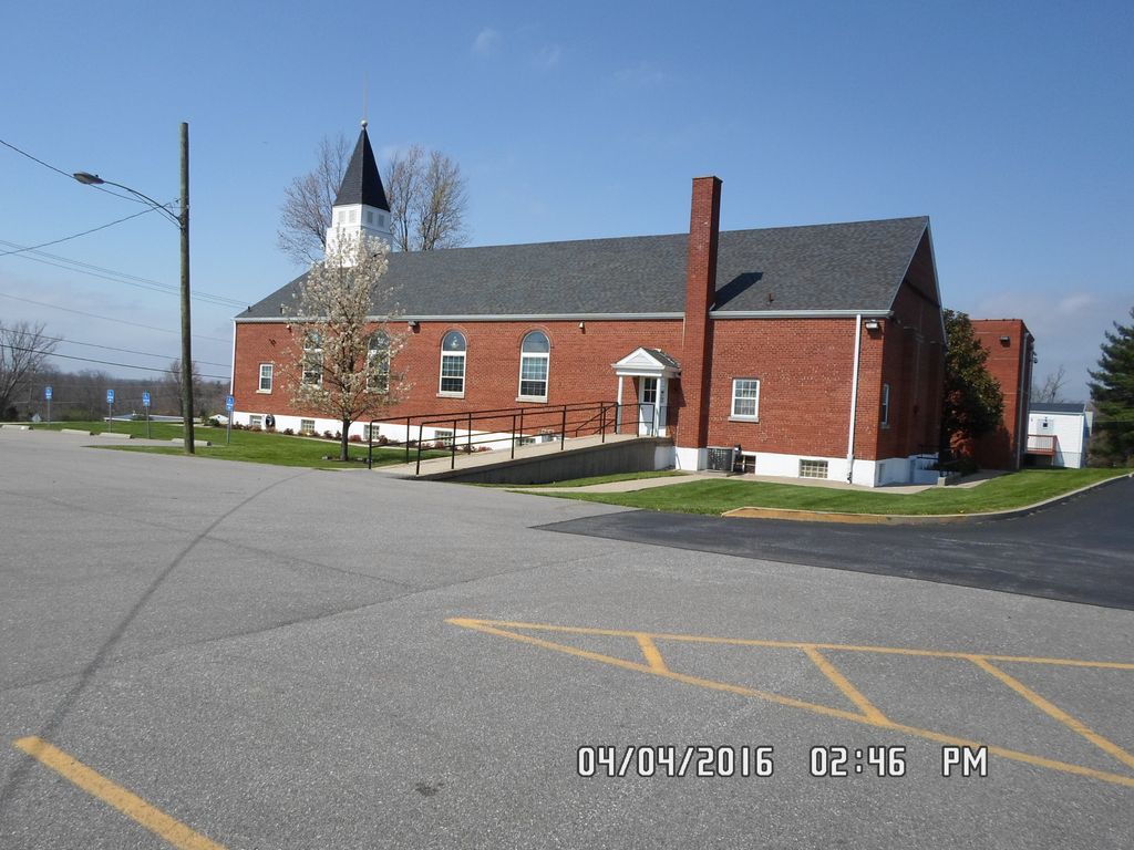
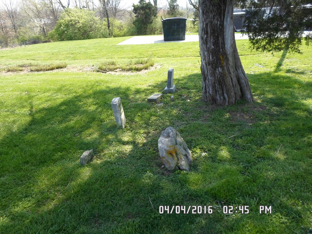
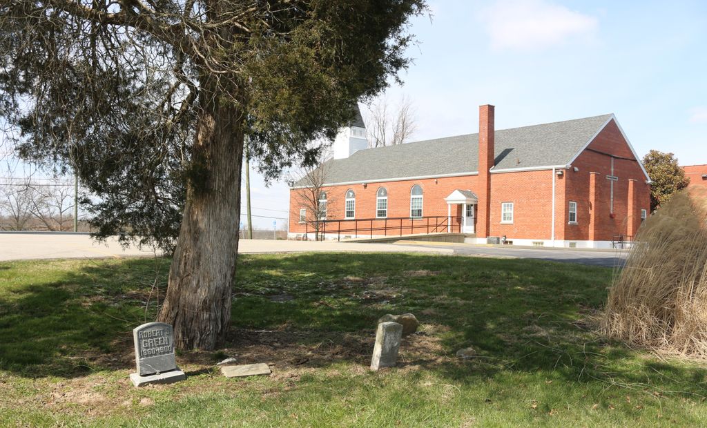
| Description | : | The cemetery is listed as Oak Ridge Church Cemetery on page 63 of Small Kenton County, Kentucky, Cemeteries, published by the Kenton County Historical Society, Cemetery Committee, and on page 63 of Kenton County Cemeteries, published by the Kenton County Historical Society, Covington, Kentucky, 1981. The cemetery inscriptions were recorded on 23 April 1959, reporting 3 graves identifiable by inscription and 15 unidentifiable graves. The cemetery location is given as latitude 38° 58’ 10” and longitude 84° 30’ 07” in the Independence Quadrangle. The cemetery location is described as “Taylor Mill Road”. |
frequently asked questions (FAQ):
-
Where is Oak Ridge Church Cemetery?
Oak Ridge Church Cemetery is located at Taylor Mill Road Latonia Lakes, Kenton County ,Kentucky , 41015USA.
-
Oak Ridge Church Cemetery cemetery's updated grave count on graveviews.com?
0 memorials
-
Where are the coordinates of the Oak Ridge Church Cemetery?
Latitude: 38.9691460
Longitude: -84.5024180
Nearby Cemetories:
1. Lighthouse Memorial Gardens
Covington, Kenton County, USA
Coordinate: 38.9689350, -84.5025500
2. Osborn Cemetery
Latonia Lakes, Kenton County, USA
Coordinate: 38.9661110, -84.5016670
3. Richard Richardson Cemetery
Latonia Lakes, Kenton County, USA
Coordinate: 38.9741670, -84.5027780
4. Minter Cemetery
Covington, Kenton County, USA
Coordinate: 38.9642300, -84.5055100
5. Lipscomb-Richardson Cemetery
Latonia Lakes, Kenton County, USA
Coordinate: 38.9736100, -84.4958300
6. Bannister Cemetery
Taylor Mill, Kenton County, USA
Coordinate: 38.9758333, -84.5111110
7. Klette Cemetery
Latonia Lakes, Kenton County, USA
Coordinate: 38.9616670, -84.4944400
8. George W Perry Cemetery
Latonia Lakes, Kenton County, USA
Coordinate: 38.9728800, -84.4883400
9. Cox Cemetery
Covington, Kenton County, USA
Coordinate: 38.9716670, -84.5188890
10. Augustus Richardson Cemetery
Latonia Lakes, Kenton County, USA
Coordinate: 38.9811110, -84.5141670
11. William Mardis Family Cemetery
Independence, Kenton County, USA
Coordinate: 38.9613800, -84.4800100
12. Ashford Road Cemetery
Independence, Kenton County, USA
Coordinate: 38.9528850, -84.4892100
13. Woodsdale Cemetery
Taylor Mill, Kenton County, USA
Coordinate: 38.9898900, -84.5064530
14. John Richardson Cemetery
Latonia Lakes, Kenton County, USA
Coordinate: 38.9855560, -84.5194440
15. Martin Family Cemetery
Taylor Mill, Kenton County, USA
Coordinate: 38.9909400, -84.4997650
16. William Richardson Cemetery
Taylor Mill, Kenton County, USA
Coordinate: 38.9905560, -84.5094440
17. Pelly Cemetery
Latonia Lakes, Kenton County, USA
Coordinate: 38.9611110, -84.5294440
18. Wolf Family Cemetery
Taylor Mill, Kenton County, USA
Coordinate: 38.9926920, -84.4980570
19. Pruett - Mardis Cemetery
Independence, Kenton County, USA
Coordinate: 38.9463900, -84.4817100
20. Armstrong Cemetery #2
Ryland Heights, Kenton County, USA
Coordinate: 38.9820600, -84.4695400
21. Floral Hills Memorial Gardens
Taylor Mill, Kenton County, USA
Coordinate: 38.9986000, -84.5028000
22. Wayman Cemetery
Independence, Kenton County, USA
Coordinate: 38.9847220, -84.5347220
23. White Cemetery
Ryland Heights, Kenton County, USA
Coordinate: 38.9628600, -84.4642900
24. Stephens Cemetery
Ryland Heights, Kenton County, USA
Coordinate: 38.9374570, -84.4977570