
| Memorials | : | 2 |
| Location | : | Latonia Lakes, Kenton County, USA |
| Coordinate | : | 38.9616670, -84.4944400 |
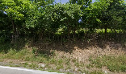
| Description | : | Klette Cemetery is located south of Latonia Lakes off Route 16 (Taylor Mill Road) on Klette Road (Route 2047). The cemetery is located on a rise approximately 100 yards off the north side of the road. The cemetery is overgrown and has not been kept up. Many of the tombstones have been knocked down and semi buried. A listing of graves was made in October 1977 and published in 1981 by the Kenton County Historical Society in Kenton County Cemeteries p 51. At that time 17 graves were identifiable by inscriptions with 2 unidentifiable graves noted. Kenneth L. Klette II... Read More |
frequently asked questions (FAQ):
-
Where is Klette Cemetery?
Klette Cemetery is located at Klette Road Latonia Lakes, Kenton County ,Kentucky , 41015USA.
-
Klette Cemetery cemetery's updated grave count on graveviews.com?
2 memorials
-
Where are the coordinates of the Klette Cemetery?
Latitude: 38.9616670
Longitude: -84.4944400
Nearby Cemetories:
1. Osborn Cemetery
Latonia Lakes, Kenton County, USA
Coordinate: 38.9661110, -84.5016670
2. Minter Cemetery
Covington, Kenton County, USA
Coordinate: 38.9642300, -84.5055100
3. Lighthouse Memorial Gardens
Covington, Kenton County, USA
Coordinate: 38.9689350, -84.5025500
4. Ashford Road Cemetery
Independence, Kenton County, USA
Coordinate: 38.9528850, -84.4892100
5. Oak Ridge Church Cemetery
Latonia Lakes, Kenton County, USA
Coordinate: 38.9691460, -84.5024180
6. William Mardis Family Cemetery
Independence, Kenton County, USA
Coordinate: 38.9613800, -84.4800100
7. Lipscomb-Richardson Cemetery
Latonia Lakes, Kenton County, USA
Coordinate: 38.9736100, -84.4958300
8. George W Perry Cemetery
Latonia Lakes, Kenton County, USA
Coordinate: 38.9728800, -84.4883400
9. Richard Richardson Cemetery
Latonia Lakes, Kenton County, USA
Coordinate: 38.9741670, -84.5027780
10. Pruett - Mardis Cemetery
Independence, Kenton County, USA
Coordinate: 38.9463900, -84.4817100
11. Bannister Cemetery
Taylor Mill, Kenton County, USA
Coordinate: 38.9758333, -84.5111110
12. Cox Cemetery
Covington, Kenton County, USA
Coordinate: 38.9716670, -84.5188890
13. White Cemetery
Ryland Heights, Kenton County, USA
Coordinate: 38.9628600, -84.4642900
14. Petty Cemetery
Ryland, Kenton County, USA
Coordinate: 38.9391000, -84.4847100
15. Stephens Cemetery
Ryland Heights, Kenton County, USA
Coordinate: 38.9374570, -84.4977570
16. Augustus Richardson Cemetery
Latonia Lakes, Kenton County, USA
Coordinate: 38.9811110, -84.5141670
17. Pelly Cemetery
Latonia Lakes, Kenton County, USA
Coordinate: 38.9611110, -84.5294440
18. White Cemetery
Ryland Heights, Kenton County, USA
Coordinate: 38.9625000, -84.4583330
19. Armstrong Cemetery #2
Ryland Heights, Kenton County, USA
Coordinate: 38.9820600, -84.4695400
20. Martin Family Cemetery
Taylor Mill, Kenton County, USA
Coordinate: 38.9909400, -84.4997650
21. Woodsdale Cemetery
Taylor Mill, Kenton County, USA
Coordinate: 38.9898900, -84.5064530
22. John Richardson Cemetery
Latonia Lakes, Kenton County, USA
Coordinate: 38.9855560, -84.5194440
23. Wolf Family Cemetery
Taylor Mill, Kenton County, USA
Coordinate: 38.9926920, -84.4980570
24. William Richardson Cemetery
Taylor Mill, Kenton County, USA
Coordinate: 38.9905560, -84.5094440