
| Memorials | : | 0 |
| Location | : | McDowell County, USA |
| Coordinate | : | 35.7008630, -82.0873780 |
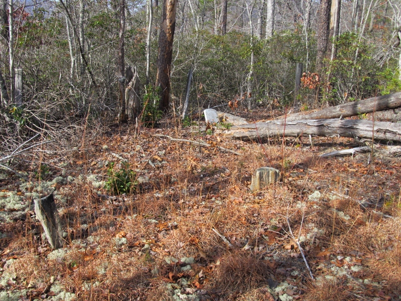
| Description | : | Directions: From Marion, take Hwy 70W to Pleasant Gardens. Turn right onto Clear Creek Road. Go 1 mile to Refuge Baptist Church. Cemetery is to the left of the church along a four-wheel drive path up the hill. Walk about 1/8 mile from church parking lot on this path. The cemetery will be in a small almost cleared area on the left. There is one tombstone and at least seven field stone markers. It is quickly becoming overgrown. We visited the cemetery on Dec 10, 2011. |
frequently asked questions (FAQ):
-
Where is Patton Cemetery?
Patton Cemetery is located at McDowell County ,North Carolina ,USA.
-
Patton Cemetery cemetery's updated grave count on graveviews.com?
0 memorials
-
Where are the coordinates of the Patton Cemetery?
Latitude: 35.7008630
Longitude: -82.0873780
Nearby Cemetories:
1. Vess Family Cemetery
Pleasant Gardens, McDowell County, USA
Coordinate: 35.6993532, -82.0866362
2. Liberty Cemetery
Marion, McDowell County, USA
Coordinate: 35.6892014, -82.0939026
3. Patton-Logan Cemetery
Pleasant Gardens, McDowell County, USA
Coordinate: 35.6907230, -82.0767370
4. Pleasant Gardens Baptist Church Cemetery
Marion, McDowell County, USA
Coordinate: 35.6933390, -82.0719010
5. Carsons Chapel Cemetery
McDowell County, USA
Coordinate: 35.7070550, -82.0706850
6. Brown Family Cemetery
Pleasant Gardens, McDowell County, USA
Coordinate: 35.6967239, -82.0679550
7. Mount Olive Cemetery
Pleasant Gardens, McDowell County, USA
Coordinate: 35.6815300, -82.1076500
8. Round Hill Baptist Church Cemetery
McDowell County, USA
Coordinate: 35.7050620, -82.0468440
9. Greenlee Hill Cemetery
McDowell County, USA
Coordinate: 35.6688700, -82.1106810
10. McDowell Cemetery
McDowell County, USA
Coordinate: 35.6638380, -82.0587210
11. Craig Family Cemetery
McDowell County, USA
Coordinate: 35.7403200, -82.0500100
12. Elliott Cemetery
McDowell County, USA
Coordinate: 35.7382830, -82.1362160
13. Mount Calvary Free Will Baptist Church Cemetery
McDowell County, USA
Coordinate: 35.6617550, -82.0401430
14. Proctor-Henline Cemetery
Marion, McDowell County, USA
Coordinate: 35.7047030, -82.0192750
15. Simmons Cemetery
Sunnyvale, McDowell County, USA
Coordinate: 35.7394070, -82.1381670
16. Nix Creek Free Will Baptist Church
Marion, McDowell County, USA
Coordinate: 35.6461500, -82.0699590
17. Cross Mill Cemetery
Marion, McDowell County, USA
Coordinate: 35.6736341, -82.0221047
18. Glades Cemetery
McDowell County, USA
Coordinate: 35.6422005, -82.0669022
19. West Marion United Methodist Church Cemetery
Marion, McDowell County, USA
Coordinate: 35.6609920, -82.0235890
20. Stroud Family Cemetery
Marion, McDowell County, USA
Coordinate: 35.7557160, -82.0419410
21. First United Methodist Church Columbarium
Marion, McDowell County, USA
Coordinate: 35.6917680, -82.0063040
22. Hicks Chapel Baptist Church Cemetery
Marion, McDowell County, USA
Coordinate: 35.7570630, -82.0415660
23. Old Marion Methodist Episcopal Church Cemetery
McDowell County, USA
Coordinate: 35.6856260, -82.0063220
24. Ebenezer United Methodist Church Cemetery
Old Fort, McDowell County, USA
Coordinate: 35.6497002, -82.1453018