
| Memorials | : | 126 |
| Location | : | Perrysville, Carroll County, USA |
| Coordinate | : | 40.4625510, -81.0973610 |
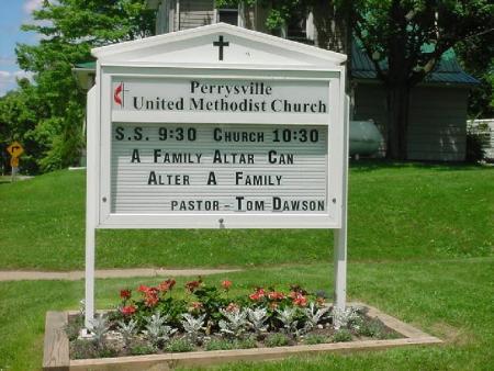
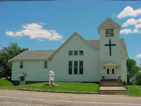
| Description | : | The cemetery is located on the east side of Amsterdam Road SW (Ohio State Route 164) behind and to the (south) side of the Perrysville United Methodist Church, formerly the Perrysville United Brethren Church. The Perrysville United Brethren Church was organized in 1848. A church building was erected in 1849. In 1946, the United Brethren and the Evangelical denominations united to form the Evangelical United Brethren Church, changing the church name to the Perrysville Evangelical United Brethren Church. In 1968, the Evangelical United Brethren and Methodist denominations united to form the United Methodist Church. Since each denomination had a church... Read More |
frequently asked questions (FAQ):
-
Where is Perrysville United Methodist Cemetery?
Perrysville United Methodist Cemetery is located at 156 – 206 Amsterdam Road SW (Ohio State Route 164) Perrysville, Carroll County ,Ohio , 43988USA.
-
Perrysville United Methodist Cemetery cemetery's updated grave count on graveviews.com?
114 memorials
-
Where are the coordinates of the Perrysville United Methodist Cemetery?
Latitude: 40.4625510
Longitude: -81.0973610
Nearby Cemetories:
1. Perrysville Methodist Episcopal Church Cemetery
Perrysville, Carroll County, USA
Coordinate: 40.4655991, -81.0982971
2. New Perrysville Cemetery
Perrysville, Carroll County, USA
Coordinate: 40.4569016, -81.1016998
3. Hagey Family Cemetery
Perrysville, Carroll County, USA
Coordinate: 40.4525980, -81.0996160
4. Arabia Cemetery
Perrysville, Carroll County, USA
Coordinate: 40.4803009, -81.0678024
5. Mount Olive Cemetery
Carroll County, USA
Coordinate: 40.4488983, -81.1382980
6. Mount Tabor Cemetery
Carroll County, USA
Coordinate: 40.4817009, -81.1483002
7. Allen Memorial Cemetery
Carroll County, USA
Coordinate: 40.4364014, -81.0511017
8. Wood Cemetery
Scio, Harrison County, USA
Coordinate: 40.4193500, -81.0707690
9. Palermo Cemetery
Carroll County, USA
Coordinate: 40.4894444, -81.1522220
10. Swinehart Cemetery
Carroll County, USA
Coordinate: 40.4327000, -81.1642170
11. Mount Pleasant Cemetery
Carrollton, Carroll County, USA
Coordinate: 40.5238991, -81.1003036
12. Conotton Cemetery
Harrison County, USA
Coordinate: 40.4103012, -81.1489029
13. Abel Cemetery
Carroll County, USA
Coordinate: 40.4578018, -81.0113983
14. Methodist Episcopal Church Cemetery
Scio, Harrison County, USA
Coordinate: 40.3970800, -81.0864600
15. Grandview Cemetery
Scio, Harrison County, USA
Coordinate: 40.3903008, -81.0978012
16. New Hagerstown Cemetery
New Hagerstown, Carroll County, USA
Coordinate: 40.4446983, -81.1893997
17. Bethel Cemetery
Leavittsville, Carroll County, USA
Coordinate: 40.4921989, -81.1841965
18. Kilgore Cemetery
Kilgore, Carroll County, USA
Coordinate: 40.4632988, -81.0014038
19. Kilgore Presbyterian Cemetery
Carroll County, USA
Coordinate: 40.4603004, -81.0002975
20. Longview Cemetery
Bowerston, Harrison County, USA
Coordinate: 40.4324989, -81.1872025
21. United Brethren Cemetery
Harrison County, USA
Coordinate: 40.4043999, -81.0353012
22. New Rumley Methodist Cemetery
New Rumley, Harrison County, USA
Coordinate: 40.4028015, -81.0346985
23. Seceders Cemetery
Carroll County, USA
Coordinate: 40.5332985, -81.1446991
24. Evangelical Lutheran Cemetery
New Rumley, Harrison County, USA
Coordinate: 40.4019012, -81.0271988