
| Memorials | : | 437 |
| Location | : | Delphos, Allen County, USA |
| Coordinate | : | 40.8423620, -84.3319580 |
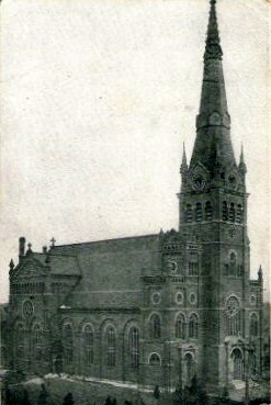
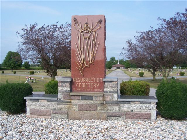
| Description | : | The cemetery is located on the south side of E 1st Street from about 500 feet east of S Pierce Street to Summers Street. The cemetery is the older of two cemeteries, which are 2.2 miles apart, associated with the Saint John The Evangelist Catholic Parish in Delphos. The cemetery is southeast of the parish church building. The cemetery is located in Marion Township, Allen County, Ohio, and is # 178 (Saint Johns Cemetery / Resurrection Cemetery) in “Ohio Cemeteries 1803-2003”, compiled by the Ohio Genealogical Society. The cemetery is registered with the Ohio Division of Real... Read More |
frequently asked questions (FAQ):
-
Where is Saint John's Catholic Cemetery?
Saint John's Catholic Cemetery is located at E 1st Street Delphos, Allen County ,Ohio , 45833USA.
-
Saint John's Catholic Cemetery cemetery's updated grave count on graveviews.com?
402 memorials
-
Where are the coordinates of the Saint John's Catholic Cemetery?
Latitude: 40.8423620
Longitude: -84.3319580


Nearby Cemetories:
1. Westside Cemetery
Delphos, Van Wert County, USA
Coordinate: 40.8452988, -84.3507996
2. Hartshorn Cemetery
Allen County, USA
Coordinate: 40.8424988, -84.2908020
3. New Saint John's Catholic Cemetery
Delphos, Allen County, USA
Coordinate: 40.8451390, -84.2889380
4. Walnut Grove Cemetery
Delphos, Allen County, USA
Coordinate: 40.8300018, -84.2906036
5. King Cemetery
Marion Township, Allen County, USA
Coordinate: 40.8060989, -84.2869034
6. Saint John the Baptist Catholic Cemetery
Landeck, Allen County, USA
Coordinate: 40.7999992, -84.3874969
7. Mount Calvary Cemetery
Fort Jennings, Putnam County, USA
Coordinate: 40.8986015, -84.3035965
8. Raabe Cemetery
Fort Jennings, Putnam County, USA
Coordinate: 40.8993988, -84.2789001
9. Saint Joseph Cemetery
Fort Jennings, Putnam County, USA
Coordinate: 40.9056015, -84.2928009
10. Pike Cemetery
Elida, Allen County, USA
Coordinate: 40.7947006, -84.2585983
11. King Cemetery
Middle Point, Van Wert County, USA
Coordinate: 40.8664017, -84.4377975
12. Saint Marys Cemetery
Ottoville, Putnam County, USA
Coordinate: 40.9261017, -84.3399963
13. Hammons Cemetery
Ottoville, Putnam County, USA
Coordinate: 40.9223370, -84.3701410
14. Horeb Cemetery
Venedocia, Van Wert County, USA
Coordinate: 40.8005981, -84.4341965
15. West Union Cemetery
Spencerville, Allen County, USA
Coordinate: 40.7574997, -84.3641968
16. Carmen Cemetery
Gomer, Allen County, USA
Coordinate: 40.8531380, -84.2118660
17. Doner Cemetery
Elida, Allen County, USA
Coordinate: 40.7951330, -84.2277470
18. Sharon Mennonite Cemetery
Elida, Allen County, USA
Coordinate: 40.7828080, -84.2332721
19. Keirns Cemetery
Sugar Creek Township, Putnam County, USA
Coordinate: 40.8875008, -84.2181015
20. Hadding Cemetery
Gomer, Allen County, USA
Coordinate: 40.8319016, -84.2035980
21. Hartford Cemetery
Spencerville, Allen County, USA
Coordinate: 40.7386017, -84.3158035
22. Old Hartford Cemetery
Allen County, USA
Coordinate: 40.7371788, -84.3140564
23. Ridge Cemetery
Middle Point, Van Wert County, USA
Coordinate: 40.8781013, -84.4692001
24. Lutheran Cemetery
Elida, Allen County, USA
Coordinate: 40.7877998, -84.2050018