
| Memorials | : | 0 |
| Location | : | Slidre, Vestre Slidre kommune, Norway |
| Coordinate | : | 61.0902780, 8.9800000 |
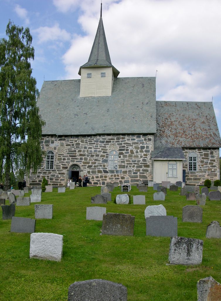
| Description | : | This church and cemetery is also known as the Slidre Cathedral and Cemetery. The church and adjoining cemetery are in Vestre Slidre kommune in Oppland County (fylke) in the Valdres area of Norway. The church is often referred to as the old stone church and is thought to have been built in the 11th century. The geographic location is 61º05'25"N, 8º,58',48"E. |
frequently asked questions (FAQ):
-
Where is Slidredomen Church and Cemetery?
Slidredomen Church and Cemetery is located at Slidre, Vestre Slidre kommune ,Oppland fylke ,Norway.
-
Slidredomen Church and Cemetery cemetery's updated grave count on graveviews.com?
0 memorials
-
Where are the coordinates of the Slidredomen Church and Cemetery?
Latitude: 61.0902780
Longitude: 8.9800000
Nearby Cemetories:
1. Vestre Slidre Cemetery
Vestre Slidre kommune, Norway
Coordinate: 61.0902130, 8.9797490
2. Øyjar Cemetery
Vestre Slidre kommune, Norway
Coordinate: 61.0435370, 9.0139510
3. Røn Cemetery
Vestre Slidre kommune, Norway
Coordinate: 61.0469680, 9.0497780
4. Rogne Cemetery
Rogne, Øystre Slidre kommune, Norway
Coordinate: 61.0874550, 9.1243580
5. Ulnes Church Cemetery
Aurdal, Nord-Aurdal kommune, Norway
Coordinate: 60.9949520, 9.1140090
6. Tingnes Kirke
Fagernes, Nord-Aurdal kommune, Norway
Coordinate: 60.9835994, 9.2585656
7. Nord Etnedal Kirke
Etnedal kommune, Norway
Coordinate: 61.0253740, 9.5010940
8. Aurdal
Aurdal, Nord-Aurdal kommune, Norway
Coordinate: 60.9248040, 9.4132630
9. Hemsedal Church Cemetery
Hemsedal, Hemsedal kommune, Norway
Coordinate: 60.8618370, 8.5635500
10. Bruflat Cemetery
Bruflat, Etnedal kommune, Norway
Coordinate: 60.8884550, 9.6389820
11. Bagn Cemetery
Bagn, Sør-Aurdal kommune, Norway
Coordinate: 60.8201360, 9.5629660
12. Leirskogen Cemetery
Begndal, Sør-Aurdal kommune, Norway
Coordinate: 60.7977150, 9.6832080
13. Leveld Church Cemetery
Al, Ål kommune, Norway
Coordinate: 60.6972348, 8.5010804
14. Svatsum Cemetery
Vestre Gausdal, Gausdal kommune, Norway
Coordinate: 61.3193320, 9.8563950
15. Aal Cemetery
Al, Ål kommune, Norway
Coordinate: 60.6290400, 8.5567350
16. Nes kirke
Nesbyen, Nes kommune, Norway
Coordinate: 60.5669920, 9.1034140
17. Kvikne Churchyard
Nord-Fron, Nord-Fron kommune, Norway
Coordinate: 61.5744000, 9.5873500
18. Borgund Stave Church Cemetery
Laerdalsoyri, Lærdal kommune, Norway
Coordinate: 61.0473408, 7.8126800
19. Vestre Gausdal Cemetery
Vestre Gausdal, Gausdal kommune, Norway
Coordinate: 61.2005670, 10.1470830
20. Hol Old Church & Cemetery
Hol, Hol kommune, Norway
Coordinate: 60.6150040, 8.3000550
21. Hedalen Cemetery
Hedalen, Sør-Aurdal kommune, Norway
Coordinate: 60.6226500, 9.6905850
22. Ostsinni Church Cemetery
Dokka, Nordre Land kommune, Norway
Coordinate: 60.8490580, 10.0783310
23. Østre Gausdal Cemetery
Gausdal kommune, Norway
Coordinate: 61.2573900, 10.1552000
24. Hovet Church and Cemetery
Hovet, Hol kommune, Norway
Coordinate: 60.6004500, 8.3001700