
| Memorials | : | 69 |
| Location | : | High Worsall, Hambleton District, England |
| Coordinate | : | 54.4786500, -1.4059590 |
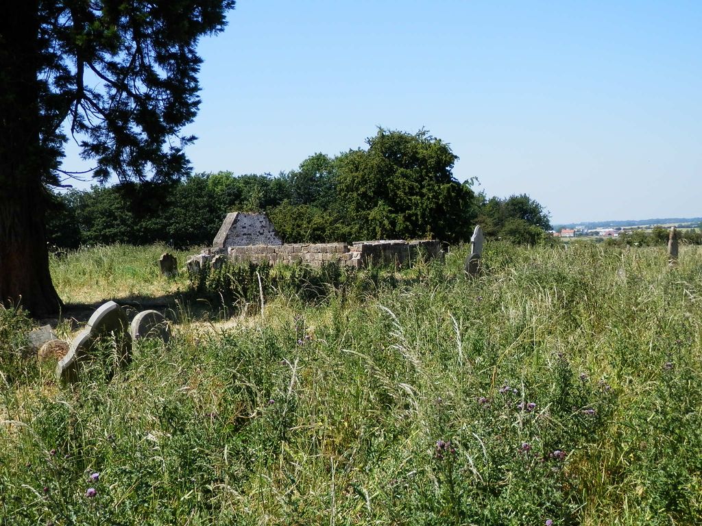
| Description | : | Remnants of the original church building are visible in the churchyard. The church, dedicated to St John, was built in 1719, although this was probably the site of a church as early as 1204. The chancel of the church was pulled down in 1892. The earliest memorial in the churchyard is from 1729 and the last recorded interment was in 1939. A burial register specifically for St John Churchyard dating from 1720-1812 has been deposited with the North Yorkshire County Record Office, Malpas Road, Northallerton, North Yorkshire DL7 8TB. Later (mid 19th century) Bishop's transcripts are with the Borthwick Institute for... Read More |
frequently asked questions (FAQ):
-
Where is St John Churchyard?
St John Churchyard is located at High Worsall, Hambleton District ,North Yorkshire ,England.
-
St John Churchyard cemetery's updated grave count on graveviews.com?
67 memorials
-
Where are the coordinates of the St John Churchyard?
Latitude: 54.4786500
Longitude: -1.4059590
Nearby Cemetories:
1. All Saints Churchyard
Low Worsall, Hambleton District, England
Coordinate: 54.4824880, -1.3898180
2. Saint George's Churchyard Low Middleton
Middleton St George, Darlington Unitary Authority, England
Coordinate: 54.4994000, -1.4366000
3. All Saints Churchyard
Girsby, Hambleton District, England
Coordinate: 54.4691000, -1.4554000
4. All Saints Churchyard
Sockburn, Darlington Unitary Authority, England
Coordinate: 54.4582000, -1.4619000
5. Yarm Cemetery
Yarm, Stockton-on-Tees Unitary Authority, England
Coordinate: 54.5037700, -1.3559300
6. Saint John the Baptist Churchyard
Low Dinsdale, Darlington Unitary Authority, England
Coordinate: 54.4950000, -1.4660000
7. St. Martin's Churchyard
Kirklevington, Stockton-on-Tees Unitary Authority, England
Coordinate: 54.4822940, -1.3351050
8. Saint Mary Magdalene Churchyard
Yarm, Stockton-on-Tees Unitary Authority, England
Coordinate: 54.5101150, -1.3575280
9. Saint Laurence's Churchyard
Middleton St George, Darlington Unitary Authority, England
Coordinate: 54.5054700, -1.4625400
10. St Mary Churchyard
Appleton Wiske, Hambleton District, England
Coordinate: 54.4360250, -1.4003270
11. St. John the Baptist Churchyard
Egglescliffe, Stockton-on-Tees Unitary Authority, England
Coordinate: 54.5121000, -1.3518000
12. Egglescliffe Cemetery
Egglescliffe, Stockton-on-Tees Unitary Authority, England
Coordinate: 54.5127200, -1.3520100
13. All Saints Churchyard
Crathorne, Hambleton District, England
Coordinate: 54.4615000, -1.3176000
14. St Eloy Churchyard
Great Smeaton, Hambleton District, England
Coordinate: 54.4343000, -1.4647000
15. Neasham Priory
Sockburn, Darlington Unitary Authority, England
Coordinate: 54.4851000, -1.5035000
16. St Mary the Virgin Churchyard
Eryholme, Richmondshire District, England
Coordinate: 54.4754000, -1.5067000
17. St Oswald Churchyard
West Rounton, Hambleton District, England
Coordinate: 54.4243670, -1.3638680
18. St. Mary's Churchyard
Long Newton, Stockton-on-Tees Unitary Authority, England
Coordinate: 54.5417700, -1.4098500
19. St. Lawrence Churchyard
East Rounton, Hambleton District, England
Coordinate: 54.4241000, -1.3510700
20. St Leonard Churchyard
Welbury, Hambleton District, England
Coordinate: 54.4138000, -1.3855600
21. All Saints Churchyard
Deighton, Hambleton District, England
Coordinate: 54.4099130, -1.4141500
22. All Saints Churchyard
Hurworth, Darlington Unitary Authority, England
Coordinate: 54.4869900, -1.5285200
23. St. John's Churchyard
Elton, Stockton-on-Tees Unitary Authority, England
Coordinate: 54.5500830, -1.3803290
24. Saint Peter’s Church
Hilton, Stockton-on-Tees Unitary Authority, England
Coordinate: 54.4950000, -1.2825000