
| Memorials | : | 0 |
| Location | : | Royston, North Hertfordshire District, England |
| Coordinate | : | 52.0478410, -0.0218200 |
| Description | : | Royston is a town and civil parish in the District of North Hertfordshire and county of Hertfordshire in England. It is situated on the Greenwich Meridian, which brushes the town's eastern boundary, and at the northernmost apex of the county on the same latitude as towns such as Milton Keynes and Ipswich. It is located 43 miles (69 km) north of central London in a rural area. Before the boundary changes of the 1890s, the boundary between Hertfordshire and Cambridgeshire ran east-west through the centre of town along the middle of Melbourn Street. |
frequently asked questions (FAQ):
-
Where is St John the Baptist Churchyard?
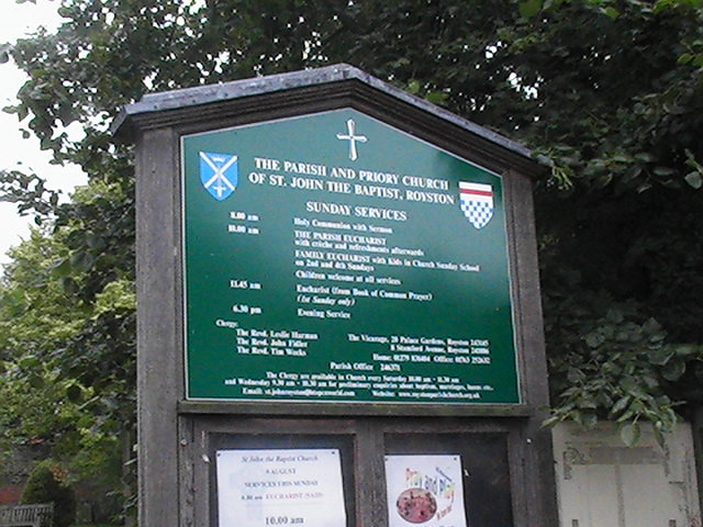
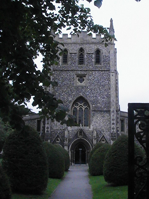
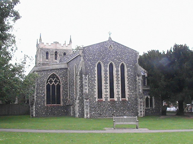
St John the Baptist Churchyard is located at Church Street Royston, North Hertfordshire District ,Hertfordshire , S71 4QZEngland.
-
St John the Baptist Churchyard cemetery's updated grave count on graveviews.com?
0 memorials
-
Where are the coordinates of the St John the Baptist Churchyard?
Latitude: 52.0478410
Longitude: -0.0218200
Nearby Cemetories:
1. Royston Cemetery
Royston, North Hertfordshire District, England
Coordinate: 52.0522860, -0.0190440
2. Bassingbourn-cum-Kneesworth Cemetery
Bassingbourn-cum-Kneesworth, South Cambridgeshire District, England
Coordinate: 52.0802380, -0.0488110
3. St Mary the Virgin Churchyard
Therfield, North Hertfordshire District, England
Coordinate: 52.0162060, -0.0568230
4. St. Peter and St. Paul Churchyard
Bassingbourn, South Cambridgeshire District, England
Coordinate: 52.0789460, -0.0598880
5. Melbourn United Reformed Churchyard
Melbourn, South Cambridgeshire District, England
Coordinate: 52.0811610, 0.0165870
6. Melbourn Burial Ground
Melbourn, South Cambridgeshire District, England
Coordinate: 52.0834230, 0.0202940
7. St Mary Churchyard
Reed, North Hertfordshire District, England
Coordinate: 52.0034714, -0.0183250
8. St. Margaret of Antioch Churchyard
Barley, North Hertfordshire District, England
Coordinate: 52.0264390, 0.0416390
9. St Faiths Churchyard
Kelshall, North Hertfordshire District, England
Coordinate: 52.0084230, -0.0656070
10. Barkway Chapel Cemetery
Barkway, North Hertfordshire District, England
Coordinate: 52.0047910, 0.0151040
11. St Mary Magdalene Churchyard
Barkway, North Hertfordshire District, England
Coordinate: 52.0015793, 0.0129600
12. Church of St. Mary The Virgin Cemetery
Whaddon, South Cambridgeshire District, England
Coordinate: 52.1012000, -0.0311000
13. THE CHURCH OF ST MARY THE VIRGIN
Whaddon, South Cambridgeshire District, England
Coordinate: 52.1012000, -0.0311000
14. Holy Trinity Churchyard
Meldreth, South Cambridgeshire District, England
Coordinate: 52.1024700, 0.0101600
15. St Michael and All Angels Churchyard
Abington Pigotts, South Cambridgeshire District, England
Coordinate: 52.0849450, -0.0976970
16. St Swithin Churchyard
Great Chishill, South Cambridgeshire District, England
Coordinate: 52.0300090, 0.0715990
17. St Andrew Churchyard
Buckland, East Hertfordshire District, England
Coordinate: 51.9866510, -0.0230880
18. St Nicholas Churchyard
Little Chishill, South Cambridgeshire District, England
Coordinate: 52.0154690, 0.0654890
19. All Saints Churchyard
Sandon, North Hertfordshire District, England
Coordinate: 51.9934160, -0.0756170
20. St Peter and St Paul
Steeple Morden, South Cambridgeshire District, England
Coordinate: 52.0655979, -0.1257247
21. Holy Trinity Churchyard
Heydon, South Cambridgeshire District, England
Coordinate: 52.0399400, 0.0868500
22. All Saints Churchyard
Shepreth, South Cambridgeshire District, England
Coordinate: 52.1081000, 0.0323800
23. All Saints Churchyard
Wendy, South Cambridgeshire District, England
Coordinate: 52.1110400, -0.0703100
24. Fowlmere Cemetery
Fowlmere, South Cambridgeshire District, England
Coordinate: 52.0989000, 0.0613500