
| Memorials | : | 0 |
| Location | : | Great Chishill, South Cambridgeshire District, England |
| Coordinate | : | 52.0300090, 0.0715990 |
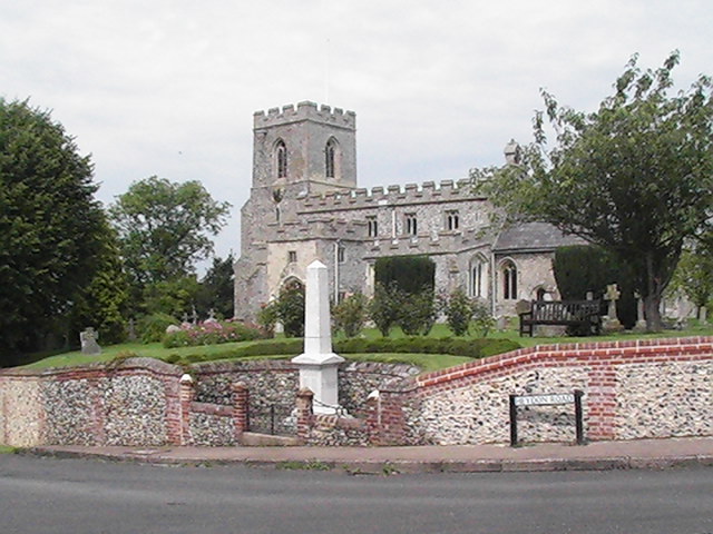
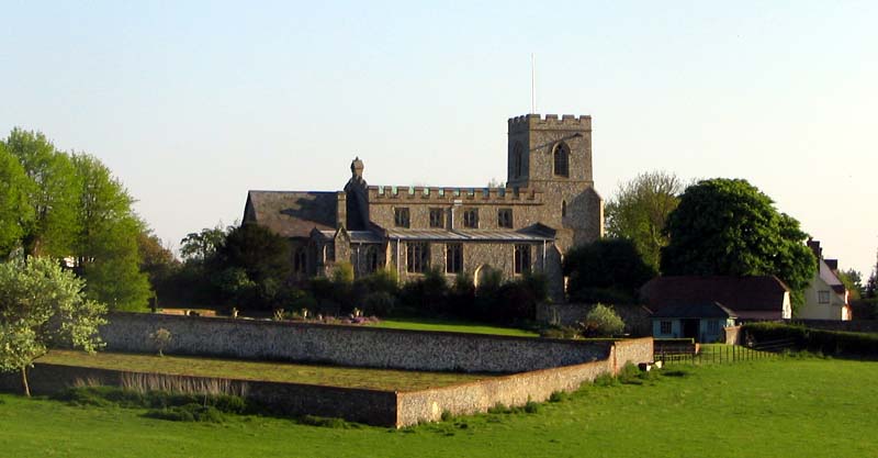
| Description | : | St. Swithun's Church, situated on high ground at the Cross Roads was founded in 1136 by Geffrey de Magnaville under the Monastery of (Saffron) Walden, but almost certainly there would have been a place of worship there before with the position of Deep Well House just behind it. Wells, Springs, High Ground and Ash Trees were always places of deep religious significance. The Church has had a chequered history of partly collapsing and being re-built over the generations. The five Bells were rung for the first time in 23 years on September the 12th 1998 as the beginning of a... Read More |
frequently asked questions (FAQ):
-
Where is St Swithin Churchyard?
St Swithin Churchyard is located at Great Chishill, South Cambridgeshire District ,Cambridgeshire ,England.
-
St Swithin Churchyard cemetery's updated grave count on graveviews.com?
0 memorials
-
Where are the coordinates of the St Swithin Churchyard?
Latitude: 52.0300090
Longitude: 0.0715990
Nearby Cemetories:
1. Holy Trinity Churchyard
Heydon, South Cambridgeshire District, England
Coordinate: 52.0399400, 0.0868500
2. St Nicholas Churchyard
Little Chishill, South Cambridgeshire District, England
Coordinate: 52.0154690, 0.0654890
3. St. Margaret of Antioch Churchyard
Barley, North Hertfordshire District, England
Coordinate: 52.0264390, 0.0416390
4. Holy Trinity Churchyard
Chrishall, Uttlesford District, England
Coordinate: 52.0276500, 0.1139577
5. St. Nicholas Churchyard
Elmdon, Uttlesford District, England
Coordinate: 52.0359900, 0.1294000
6. St. John The Evangelist Churchyard
Langley, Uttlesford District, England
Coordinate: 51.9969356, 0.0995640
7. The Hamlet Church Cemetery
Duddenhoe End, Uttlesford District, England
Coordinate: 52.0145269, 0.1285385
8. Barkway Chapel Cemetery
Barkway, North Hertfordshire District, England
Coordinate: 52.0047910, 0.0151040
9. St Mary Magdalene Churchyard
Barkway, North Hertfordshire District, England
Coordinate: 52.0015793, 0.0129600
10. St George Churchyard
Anstey, East Hertfordshire District, England
Coordinate: 51.9766990, 0.0431300
11. Saint Mary Churchyard
Meesden, East Hertfordshire District, England
Coordinate: 51.9728000, 0.0934270
12. Royston Cemetery
Royston, North Hertfordshire District, England
Coordinate: 52.0522860, -0.0190440
13. St John the Baptist Churchyard
Royston, North Hertfordshire District, England
Coordinate: 52.0478410, -0.0218200
14. Fowlmere United Reformed Churchyard
Fowlmere, South Cambridgeshire District, England
Coordinate: 52.0902000, 0.0734000
15. Melbourn United Reformed Churchyard
Melbourn, South Cambridgeshire District, England
Coordinate: 52.0811610, 0.0165870
16. St Mary Churchyard
Reed, North Hertfordshire District, England
Coordinate: 52.0034714, -0.0183250
17. Melbourn Burial Ground
Melbourn, South Cambridgeshire District, England
Coordinate: 52.0834230, 0.0202940
18. St Mary Churchyard
Fowlmere, South Cambridgeshire District, England
Coordinate: 52.0933800, 0.0750800
19. St Margaret Churchyard
Arkesden, Uttlesford District, England
Coordinate: 51.9897000, 0.1571200
20. Fowlmere Cemetery
Fowlmere, South Cambridgeshire District, England
Coordinate: 52.0989000, 0.0613500
21. St Andrew Churchyard
Buckland, East Hertfordshire District, England
Coordinate: 51.9866510, -0.0230880
22. St George Churchyard
Thriplow, South Cambridgeshire District, England
Coordinate: 52.1021560, 0.1040390
23. Ss Mary and Clement Churchyard
Clavering, Uttlesford District, England
Coordinate: 51.9653720, 0.1393760
24. St Giles Churchyard
Wyddial, East Hertfordshire District, England
Coordinate: 51.9673270, -0.0010730