
| Memorials | : | 0 |
| Location | : | Boughton, Daventry District, England |
| Phone | : | 01604 845655 |
| Coordinate | : | 52.2861187, -0.8971496 |
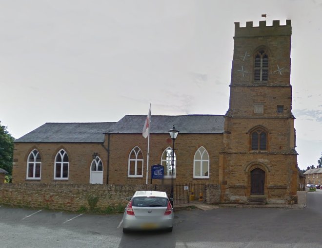
| Description | : | St. John the Baptist’s Church is an Anglican Church and the parish church of Boughton. It is a Grade II listed building and stands on the north-east side of Church Street, next door to The Whyte Melville pub. The present church was built on the site of a 14th Century Chantry and dates back to 1350. The church is small with a vestry, west tower that dates to circa 1400, the only remaining original section. All other additions are modern. |
frequently asked questions (FAQ):
-
Where is St John the Baptist Churchyard?
St John the Baptist Churchyard is located at Church Street Boughton, Daventry District ,Northamptonshire , NN2 8SFEngland.
-
St John the Baptist Churchyard cemetery's updated grave count on graveviews.com?
0 memorials
-
Where are the coordinates of the St John the Baptist Churchyard?
Latitude: 52.2861187
Longitude: -0.8971496
Nearby Cemetories:
1. Old St John the Baptist Churchyard
Boughton, Daventry District, England
Coordinate: 52.2836464, -0.8801961
2. Kingsthorpe Cemetery
Kingsthorpe, Northampton Borough, England
Coordinate: 52.2740400, -0.9001200
3. All Saints Churchyard
Pitsford, Daventry District, England
Coordinate: 52.3066700, -0.8952200
4. St Botolph Churchyard
Church Brampton, Daventry District, England
Coordinate: 52.2849866, -0.9486724
5. Dallington Cemetery
Northampton, Northampton Borough, England
Coordinate: 52.2505200, -0.9287200
6. Northampton Gaol Cemetery
Northampton, Northampton Borough, England
Coordinate: 52.2418540, -0.8940440
7. St Peter and St Paul Churchyard
Abington, Northampton Borough, England
Coordinate: 52.2461580, -0.8653790
8. St. Sepulchre Churchyard
Northampton, Northampton Borough, England
Coordinate: 52.2414600, -0.8973600
9. Cemetery of the Sisters of Notre Dame
Northampton Borough, England
Coordinate: 52.2399000, -0.8923333
10. Weston Favel Cemetery
Weston Favell, Northampton Borough, England
Coordinate: 52.2492980, -0.8483410
11. All Saints Church
Northampton, Northampton Borough, England
Coordinate: 52.2371129, -0.8964385
12. Billing Road Cemetery
Northampton, Northampton Borough, England
Coordinate: 52.2387200, -0.8750900
13. St Andrew Churchyard
Spratton, Daventry District, England
Coordinate: 52.3243520, -0.9483460
14. Northampton County Goal Cemetery
Northampton, Northampton Borough, England
Coordinate: 52.2364470, -0.8945440
15. St. Mary & All Saints Churchyard
Holcot, Daventry District, England
Coordinate: 52.3208630, -0.8390120
16. Saint Luke Churchyard
Duston, Northampton Borough, England
Coordinate: 52.2428820, -0.9396550
17. Spencer Estate Grounds
Althorp, Daventry District, England
Coordinate: 52.2839190, -0.9889520
18. Great Billing Churchyard
Northampton, Northampton Borough, England
Coordinate: 52.2581240, -0.8172800
19. All Saints Churchyard
Holdenby, Daventry District, England
Coordinate: 52.3021000, -0.9868100
20. Great Billing Catholic Cemetery
Billing, Northampton Borough, England
Coordinate: 52.2577300, -0.8130700
21. All Saints Churchyard Little Billing
Billing, Northampton Borough, England
Coordinate: 52.2484300, -0.8228800
22. St Michael's Churchyard
Upton, Northampton Borough, England
Coordinate: 52.2356600, -0.9508160
23. St Peter and St Paul Churchyard
Scaldwell, Daventry District, England
Coordinate: 52.3459100, -0.8732100
24. Ss Peter and Paul Churchyard
Sywell, Wellingborough Borough, England
Coordinate: 52.2968890, -0.7965030