
| Memorials | : | 0 |
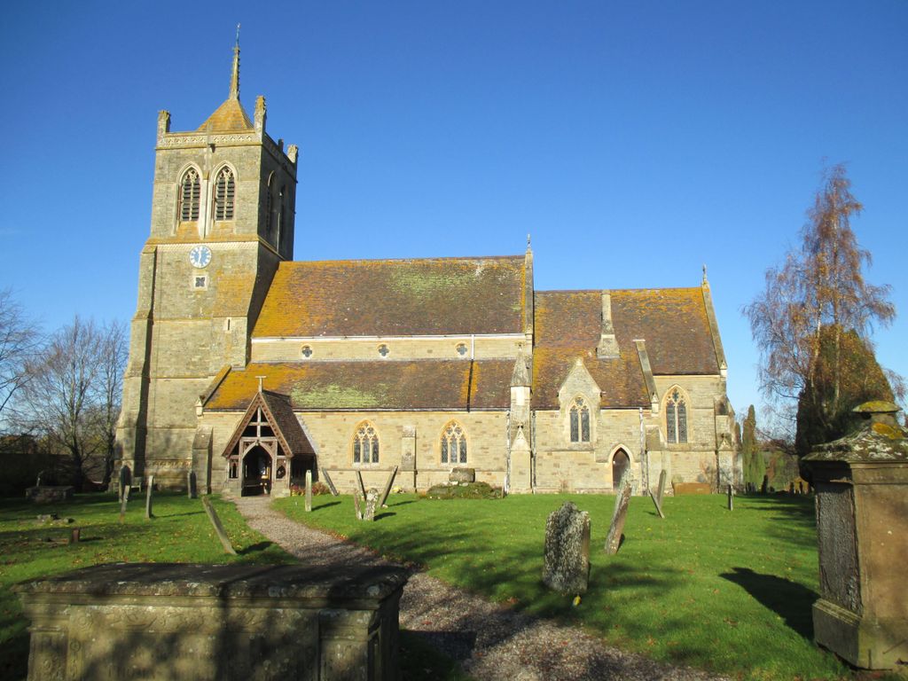
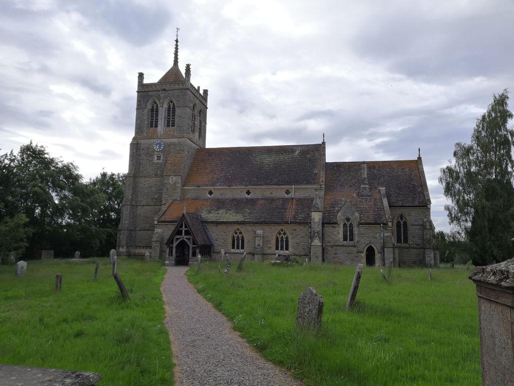
| Location | : | Suckley, Malvern Hills District, England |
| Coordinate | : | 52.1622900, -2.4093700 |
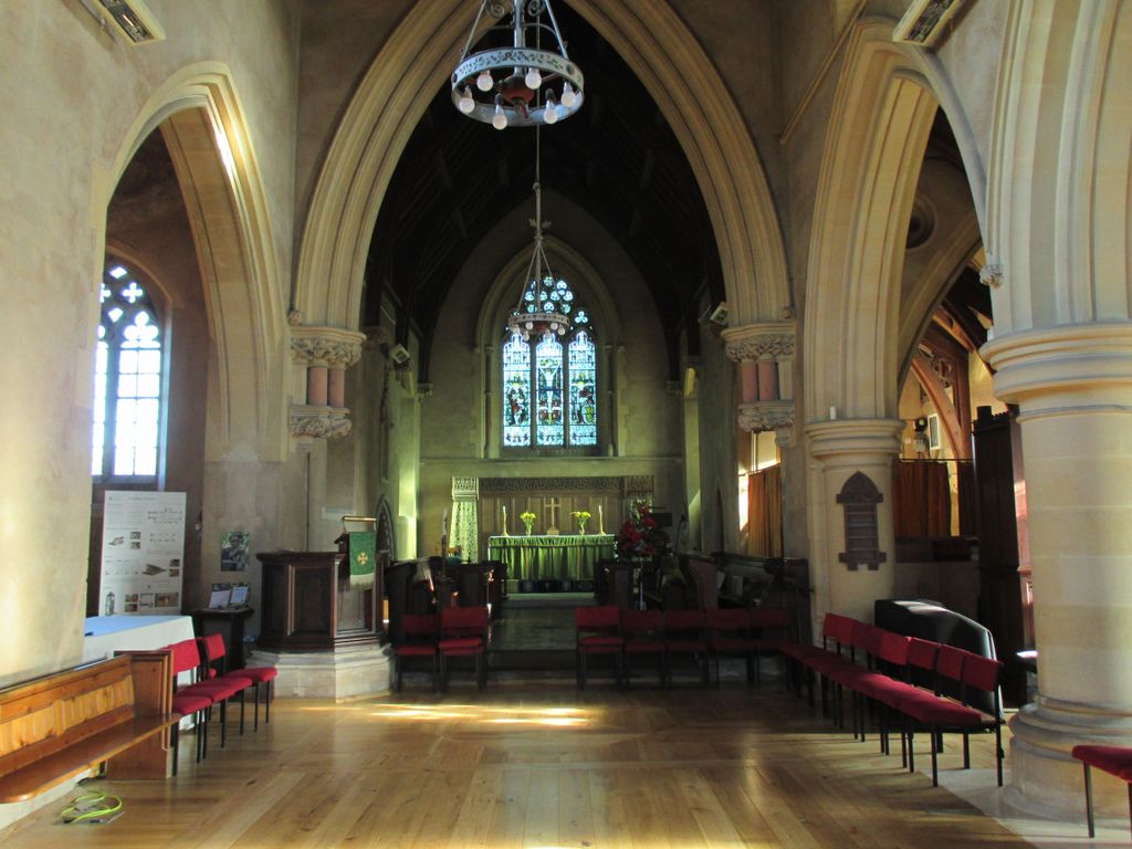
| Description | : | This church was completed in 1879 and enshrines many features of a church which stood on the same site since early Norman times. It is built in Cradley stone, from nearby Ridgeway Cross, with Bath stone dressing. Outside the church on the south front are the remains of a mediaeval preaching cross, the base scarred with grooves, probably made by the sharpening of arrows at the compulsory archery practices. Entering the church by the south door you see on the left the interesting Norman Tub Font, dating from about 1150-1200, with seventeenth century domed cover. The pulpit is Jacobean, about 300 years old. On... Read More |
frequently asked questions (FAQ):
-
Where is St. John the Baptist Churchyard?
St. John the Baptist Churchyard is located at Church Lane Suckley, Malvern Hills District ,Worcestershire , WR6 5DEEngland.
-
St. John the Baptist Churchyard cemetery's updated grave count on graveviews.com?
0 memorials
-
Where are the coordinates of the St. John the Baptist Churchyard?
Latitude: 52.1622900
Longitude: -2.4093700
Nearby Cemetories:
1. St Mary Magdalene Churchyard
Alfrick, Malvern Hills District, England
Coordinate: 52.1744230, -2.3693070
2. Knightwick Chapel
Knightwick, Malvern Hills District, England
Coordinate: 52.1946400, -2.3989800
3. St Giles Churchyard
Acton Beauchamp, Herefordshire Unitary Authority, England
Coordinate: 52.1500729, -2.4699471
4. Cradley Chapel
Cradley, Herefordshire Unitary Authority, England
Coordinate: 52.1215478, -2.4001078
5. St. James' the Great Churchyard
Cradley, Herefordshire Unitary Authority, England
Coordinate: 52.1218440, -2.3870920
6. St. Mary Magdalene Churchyard
Broadwas, Malvern Hills District, England
Coordinate: 52.1938300, -2.3598200
7. St. Peter's Churchyard
Malvern Link, Malvern Hills District, England
Coordinate: 52.1259530, -2.3380280
8. St. Eadburga Churchyard
Leigh, Malvern Hills District, England
Coordinate: 52.1789500, -2.3169500
9. St Marys Churchyard
Bishops Frome, Herefordshire Unitary Authority, England
Coordinate: 52.1321100, -2.4931300
10. St. James's Churchyard
West Malvern, Malvern Hills District, England
Coordinate: 52.1127220, -2.3469830
11. St James Churchyard
Great Malvern, Malvern Hills District, England
Coordinate: 52.1197650, -2.3316900
12. St Leonard Churchyard
Cotheridge, Malvern Hills District, England
Coordinate: 52.1903100, -2.3139500
13. St. Matthias Churchyard
Malvern Link, Malvern Hills District, England
Coordinate: 52.1290490, -2.3178900
14. St. John the Baptist Churchyard
Bransford, Malvern Hills District, England
Coordinate: 52.1616486, -2.2981676
15. Convent of the Holy Name, Chapel and Cloister
Malvern Link, Malvern Hills District, England
Coordinate: 52.1304500, -2.3068900
16. St Michaels & All Angels Churchyard
Castle Frome, Herefordshire Unitary Authority, England
Coordinate: 52.1098604, -2.4871622
17. Great Malvern Priory Churchyard
Great Malvern, Malvern Hills District, England
Coordinate: 52.1106750, -2.3284660
18. Newland Cemetery
Newland, Malvern Hills District, England
Coordinate: 52.1342764, -2.2988052
19. Great Malvern Cemetery
Great Malvern, Malvern Hills District, England
Coordinate: 52.1133010, -2.3135120
20. Holy Trinity Churchyard
Bosbury, Herefordshire Unitary Authority, England
Coordinate: 52.0885430, -2.4459180
21. St. Peter's Churchyard
Martley, Malvern Hills District, England
Coordinate: 52.2359520, -2.3582940
22. All Saints Churchyard
Coddington, Herefordshire Unitary Authority, England
Coordinate: 52.0820020, -2.4123970
23. St. Mary's Church at Edvin Loach Old Church
Bromyard, Herefordshire Unitary Authority, England
Coordinate: 52.2230907, -2.4953840
24. St Mary the Virgin Churchyard
Madresfield, Malvern Hills District, England
Coordinate: 52.1252800, -2.2864800