
| Memorials | : | 0 |
| Location | : | Southampton, Southampton Unitary Authority, England |
| Coordinate | : | 50.8965000, -1.4036000 |
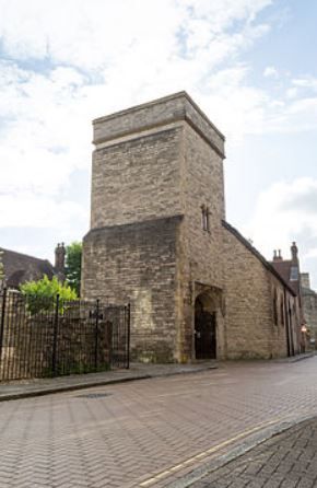
| Description | : | Located on Winkle Street in Southampton, the chapel was founded about 1197 as part of a Leper's hospital and a hostel for travelers to Canterbury. Since the 16th century, the church as been used, with the permission of Queen Elizabeth I, by the French Protestants, thus it is also known as the “French Church.” Services, that were spoken in French, were discontinued in 1939. The church has sitting for 200 people. In error, the church is sometimes referred in documents as “St Julian's” but maps and surveys prove it is St. Julien's. Inside the church is the Leper's Squint Stoup... Read More |
frequently asked questions (FAQ):
-
Where is St. Julien's Church?
St. Julien's Church is located at Winkle Street, Rue Es Picots Southampton, Southampton Unitary Authority ,Hampshire , SO14England.
-
St. Julien's Church cemetery's updated grave count on graveviews.com?
0 memorials
-
Where are the coordinates of the St. Julien's Church?
Latitude: 50.8965000
Longitude: -1.4036000
Nearby Cemetories:
1. St Lawrence with St John Churchyard
Southampton, Southampton Unitary Authority, England
Coordinate: 50.8977570, -1.4052470
2. Holyrood Churchyard
Southampton, Southampton Unitary Authority, England
Coordinate: 50.8996600, -1.4035300
3. Holyrood Church
Southampton Unitary Authority, England
Coordinate: 50.8997498, -1.4034560
4. St Michael the Archangel Churchyard
Southampton, Southampton Unitary Authority, England
Coordinate: 50.8996200, -1.4056900
5. All Saints Catacombs and Burial Ground (Defunct)
Southampton, Southampton Unitary Authority, England
Coordinate: 50.9013350, -1.4021500
6. St Mary Churchyard
Southampton, Southampton Unitary Authority, England
Coordinate: 50.9027100, -1.3960800
7. St. Mary Extra Churchyard
Southampton, Southampton Unitary Authority, England
Coordinate: 50.9040000, -1.3743000
8. Southampton Old Cemetery
Southampton, Southampton Unitary Authority, England
Coordinate: 50.9202900, -1.4130650
9. Holy Trinity Churchyard
Southampton, Southampton Unitary Authority, England
Coordinate: 50.8896750, -1.3659150
10. St John the Baptist Churchyard
Hythe, New Forest District, England
Coordinate: 50.8688500, -1.3985000
11. St Mary Churchyard
Sholing, Southampton Unitary Authority, England
Coordinate: 50.8991260, -1.3571350
12. All Saints Churchyard
Dibden, New Forest District, England
Coordinate: 50.8753020, -1.4362590
13. St. Nicholas Churchyard
Millbrook, Southampton Unitary Authority, England
Coordinate: 50.9139100, -1.4439800
14. St John the Apostle Churchyard
Marchwood, New Forest District, England
Coordinate: 50.8900300, -1.4530700
15. Falklands War Memorial
Marchwood, New Forest District, England
Coordinate: 50.8898280, -1.4533250
16. St Mary Extra Cemetery
Southampton, Southampton Unitary Authority, England
Coordinate: 50.8948700, -1.3522600
17. Holy Saviour Churchyard
Bitterne, Southampton Unitary Authority, England
Coordinate: 50.9138840, -1.3583560
18. Highfield Churchyard
Portswood, Southampton Unitary Authority, England
Coordinate: 50.9295400, -1.3949800
19. St James by the Park Churchyard
Shirley, Southampton Unitary Authority, England
Coordinate: 50.9266800, -1.4285800
20. St. James by the Park Cemetery
Southampton Unitary Authority, England
Coordinate: 50.9267988, -1.4283898
21. Millbrook Cemetery
Millbrook, Southampton Unitary Authority, England
Coordinate: 50.9164900, -1.4526100
22. Holy Trinity Churchyard
Millbrook, Southampton Unitary Authority, England
Coordinate: 50.9158400, -1.4535100
23. Redcote Convent Cemetery
Bitterne, Southampton Unitary Authority, England
Coordinate: 50.9168600, -1.3510700
24. Hollybrook War Memorial
Southampton, Southampton Unitary Authority, England
Coordinate: 50.9337420, -1.4311350