
| Memorials | : | 0 |
| Location | : | Hinton Parva, East Dorset District, England |
| Coordinate | : | 50.8336300, -1.9949200 |
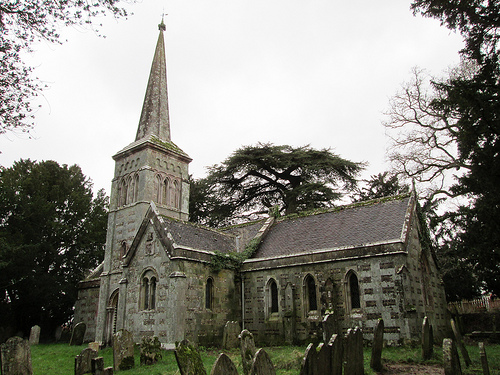
| Description | : | In 1860 Sir Richard Glyn took down the old church and replaced it with what is considered to be a fairly typical estate church. Built of stone in the neo-Romanesque style, it retains the Norman chancel arch and consists of chancel, nave, transepts, south porch supporting a spire and a tower containing 4 bells. Formerly there was a Norman church here, which John Hutchins in his ‘History and Antiquities of Dorset’ described dismissively as “a very small stone building, dedicated to St Kenelm, consisting of one aisle, and having one bell. Over the west door of Hinton Parva’s St Kenelm’s... Read More |
frequently asked questions (FAQ):
-
Where is St. Kenelm Churchyard?
St. Kenelm Churchyard is located at Hinton Parva, East Dorset District ,Dorset , BH21England.
-
St. Kenelm Churchyard cemetery's updated grave count on graveviews.com?
0 memorials
-
Where are the coordinates of the St. Kenelm Churchyard?
Latitude: 50.8336300
Longitude: -1.9949200
Nearby Cemetories:
1. St. James' Churchyard
Holt, East Dorset District, England
Coordinate: 50.8347020, -1.9585820
2. St. John The Evangelist Church
Hinton Martell, East Dorset District, England
Coordinate: 50.8551000, -1.9814000
3. Poole and Wimborne Woodland Burial Ground
Wimborne, East Dorset District, England
Coordinate: 50.8097500, -1.9745150
4. All Saints Churchyard
Witchampton, East Dorset District, England
Coordinate: 50.8574650, -2.0178710
5. Woodland Burial Ground
Colehill, East Dorset District, England
Coordinate: 50.8088100, -1.9737900
6. Witchampton Methodist Churchyard
Witchampton, East Dorset District, England
Coordinate: 50.8574990, -2.0205250
7. St Michael and All Angels Churchyard
Colehill, East Dorset District, England
Coordinate: 50.8104720, -1.9661400
8. Wimborne Cemetery
Wimborne, East Dorset District, England
Coordinate: 50.8040910, -1.9942650
9. All Saints Churchyard
Chalbury, East Dorset District, England
Coordinate: 50.8610620, -1.9750690
10. St. Cuthberga Churchyard
Wimborne Minster, East Dorset District, England
Coordinate: 50.7989260, -1.9880560
11. St. Wolfrida's Churchyard
Horton, East Dorset District, England
Coordinate: 50.8665000, -1.9585000
12. St. Mary's Churchyard
Cranborne, East Dorset District, England
Coordinate: 50.8741910, -2.0083630
13. Crichel House and Garden
Witchampton, East Dorset District, England
Coordinate: 50.8755820, -2.0072820
14. Canford Magna Parish Church
Canford Magna, East Dorset District, England
Coordinate: 50.7889000, -1.9560000
15. Canford Magna Civic Cemetery
Canford Magna, East Dorset District, England
Coordinate: 50.7845320, -1.9571820
16. Corfe Mullen Church Cemetery
Corfe Mullen, East Dorset District, England
Coordinate: 50.7848260, -2.0344940
17. Corfe Mullen Cemetery
Corfe Mullen, East Dorset District, England
Coordinate: 50.7787500, -2.0177600
18. St. Mary's Churchyard
Sturminster Marshall, East Dorset District, England
Coordinate: 50.8031270, -2.0709410
19. The Church of the Ascension Churchyard
Woodlands, East Dorset District, England
Coordinate: 50.8806164, -1.9291594
20. Gussage All Saints Churchyard
Gussage All Saints, East Dorset District, England
Coordinate: 50.8966570, -2.0031990
21. St. Mary's Churchyard
Tarrant Rushton, North Dorset District, England
Coordinate: 50.8541050, -2.0899870
22. All Saints Churchyard
Hampreston, East Dorset District, England
Coordinate: 50.7887250, -1.9231050
23. Shapwick Parish Churchyard
Shapwick, East Dorset District, England
Coordinate: 50.8147360, -2.0914850
24. St Mary's Churchyard - Long Crichel
Tarrant Hinton, North Dorset District, England
Coordinate: 50.8927141, -2.0355435