
| Memorials | : | 0 |
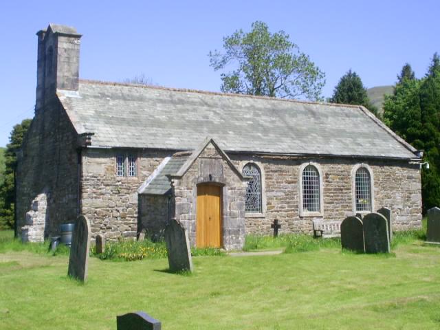
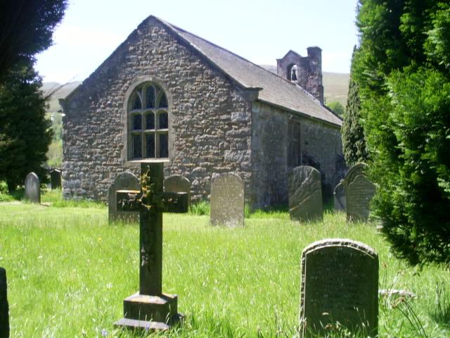
| Location | : | Mallerstang, Eden District, England |
| Coordinate | : | 54.4079040, -2.3374060 |
frequently asked questions (FAQ):
-
Where is St Mary's Churchyard?
St Mary's Churchyard is located at Mallerstang, Eden District ,Cumbria ,England.
-
St Mary's Churchyard cemetery's updated grave count on graveviews.com?
0 memorials
-
Where are the coordinates of the St Mary's Churchyard?
Latitude: 54.4079040
Longitude: -2.3374060
Nearby Cemetories:
1. High Chapel Burial Ground
Ravenstonedale, Eden District, England
Coordinate: 54.4299450, -2.4286560
2. St. Oswald Churchyard
Ravenstonedale, Eden District, England
Coordinate: 54.4329680, -2.4296740
3. St Stephen Churchyard
Kirkby Stephen, Eden District, England
Coordinate: 54.4740890, -2.3485130
4. Kirkby Stephen Cemetery
Kirkby Stephen, Eden District, England
Coordinate: 54.4784680, -2.3507840
5. St. Andrew's Churchyard
Crosby Garrett, Eden District, England
Coordinate: 54.4822030, -2.4179930
6. Soulby Cemetery
Soulby, Eden District, England
Coordinate: 54.4943900, -2.3834200
7. Saint Luke Churchyard
Soulby, Eden District, England
Coordinate: 54.4945750, -2.3897580
8. Keld United Reform Chapelyard
Keld, Richmondshire District, England
Coordinate: 54.4055920, -2.1660210
9. St. Mark's Churchyard
Cautley, South Lakeland District, England
Coordinate: 54.3456280, -2.4767630
10. Cautley Methodist Churchyard
Sedbergh, South Lakeland District, England
Coordinate: 54.3419640, -2.4791850
11. St Theobald Churchyard
Musgrave, Eden District, England
Coordinate: 54.5138380, -2.3605080
12. St Theobald's Church
Great Musgrave, Eden District, England
Coordinate: 54.5139410, -2.3605410
13. St. John the Baptist Churchyard
Garsdale, South Lakeland District, England
Coordinate: 54.3008610, -2.3914140
14. St Michael Churchyard
Brough, Eden District, England
Coordinate: 54.5201950, -2.3210920
15. Low Smithy Methodist Church Graveyard
Garsdale, South Lakeland District, England
Coordinate: 54.3003930, -2.3992090
16. St. Mary and St. John Churchyard
Hardraw, Richmondshire District, England
Coordinate: 54.3169800, -2.2052700
17. St. Mary's Churchyard
Muker, Richmondshire District, England
Coordinate: 54.3763690, -2.1392860
18. Frostrow Methodist Chapel Churchyard
Sedbergh, South Lakeland District, England
Coordinate: 54.3175080, -2.4871590
19. St. Margaret's Churchyard
Hawes, Richmondshire District, England
Coordinate: 54.3032300, -2.1969700
20. St. Columba Churchyard
Warcop, Eden District, England
Coordinate: 54.5359610, -2.3988140
21. Friends Burial Ground
Hawes, Richmondshire District, England
Coordinate: 54.3039790, -2.1937940
22. Birks Chapel Burial Ground Ingham & Congregat
Warcop, Eden District, England
Coordinate: 54.5301820, -2.4356050
23. Sandemanian Chapel Burial Ground
Hawes, Richmondshire District, England
Coordinate: 54.2992110, -2.1982010
24. St Peter's Churchyard
Great Asby, Eden District, England
Coordinate: 54.5134470, -2.4946230