
| Memorials | : | 0 |
| Location | : | Boscobel, Shropshire Unitary Authority, England |
| Coordinate | : | 52.6657000, -2.2584000 |
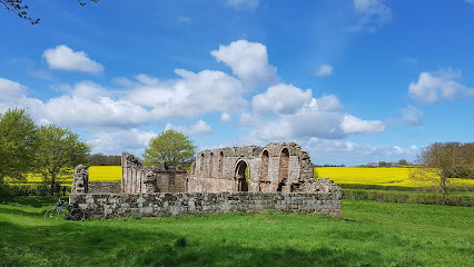
| Description | : | White Ladies Priory (often Whiteladies Priory), once the Priory of St Leonard at Brewood, was an English priory of Augustinian canonesses, now in ruins, in Shropshire, in the parish of Boscobel, some eight miles (13 km) northwest of Wolverhampton, near Junction 3 of the M54 motorway. Dissolved in 1536, it became famous for its role in the escape of Charles II of England after the Battle of Worcester in 1651. The name 'White Ladies' refers to the canonesses who lived there and who wore white religious habits. The priory is now gone, the remains of its medieval church and the... Read More |
frequently asked questions (FAQ):
-
Where is White Ladies Priory?
White Ladies Priory is located at Boscobel, Shropshire Unitary Authority ,Shropshire ,England.
-
White Ladies Priory cemetery's updated grave count on graveviews.com?
0 memorials
-
Where are the coordinates of the White Ladies Priory?
Latitude: 52.6657000
Longitude: -2.2584000
Nearby Cemetories:
1. Saint Johns Church
Bishops Wood, Shropshire Unitary Authority, England
Coordinate: 52.6810030, -2.2369880
2. St. Cuthbert's Churchyard
Albrighton, Shropshire Unitary Authority, England
Coordinate: 52.6392906, -2.2838705
3. St Mary Magdalene Churchyard
Albrighton, Shropshire Unitary Authority, England
Coordinate: 52.6373060, -2.2831290
4. St Andrew Church
Weston-under-Lizard, South Staffordshire Borough, England
Coordinate: 52.6932000, -2.2883000
5. St. Chad
Boningale, Shropshire Unitary Authority, England
Coordinate: 52.6208330, -2.2795110
6. St. Nicholas' Churchyard
Codsall, South Staffordshire Borough, England
Coordinate: 52.6342500, -2.1992300
7. St Mary and St Chad Churchyard
Brewood, South Staffordshire Borough, England
Coordinate: 52.6754850, -2.1738520
8. Saint John's Churchyard
Stretton, South Staffordshire Borough, England
Coordinate: 52.6999790, -2.1720920
9. St Mary Patshull Burnhill Green
Pattingham, South Staffordshire Borough, England
Coordinate: 52.6056540, -2.2916790
10. All Saints Churchyard
Lapley, South Staffordshire Borough, England
Coordinate: 52.7138900, -2.1902330
11. St Chad Churchyard
Pattingham, South Staffordshire Borough, England
Coordinate: 52.5897150, -2.2656570
12. St Milburga's Churchyard
Beckbury, Shropshire Unitary Authority, England
Coordinate: 52.6113140, -2.3481180
13. Danescourt Cemetery
Tettenhall, Metropolitan Borough of Wolverhampton, England
Coordinate: 52.6033840, -2.1789160
14. Christ Church
Gailey, South Staffordshire Borough, England
Coordinate: 52.6933900, -2.1308200
15. St. Michael and All Angels Churchyard
Tettenhall, Metropolitan Borough of Wolverhampton, England
Coordinate: 52.6003380, -2.1619170
16. Woodcote Parish Church
Woodcote, Telford and Wrekin Unitary Authority, England
Coordinate: 52.7358330, -2.3456640
17. St. Giles Churchyard
Badger, Shropshire Unitary Authority, England
Coordinate: 52.5936507, -2.3438993
18. Christ Church
Tettenhall Wood, Metropolitan Borough of Wolverhampton, England
Coordinate: 52.5895828, -2.1805506
19. Telford Crematorium
Redhill, Telford and Wrekin Unitary Authority, England
Coordinate: 52.6950750, -2.3988090
20. St Mary's, Moreton
Moreton, Stafford Borough, England
Coordinate: 52.7521490, -2.3021420
21. St. Editha's Parish Church Graveyard
Church Eaton, Stafford Borough, England
Coordinate: 52.7560690, -2.2259540
22. Lilleshall Abbey
Lilleshall, Telford and Wrekin Unitary Authority, England
Coordinate: 52.7247000, -2.3898000
23. St. Mary's Churchyard
Bushbury, Metropolitan Borough of Wolverhampton, England
Coordinate: 52.6199160, -2.1130120
24. Bushbury Cemetery and Crematorium
Bushbury, Metropolitan Borough of Wolverhampton, England
Coordinate: 52.6247480, -2.1083690