
| Memorials | : | 0 |
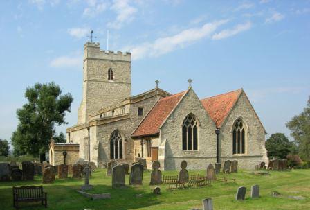
| Location | : | Whaddon, Aylesbury Vale District, England |
| Coordinate | : | 51.9993190, -0.8283310 |
| Description | : | Whaddon is an old Celtic word meaning "Wheat Hill". Whaddon stands 429 feet above sea level and was once surrounded by dense forest, the Whaddon Chase, which gives its name to the local Hunt. There is evidence that Whaddon was inhabited in pre-historic times – a flint skin-scraper was uncovered near the church. Ancient British and Roman coins have also been found, and the site of a Roman camp is nearby. Added by wertypop |
frequently asked questions (FAQ):
-
Where is St Mary Churchyard?
St Mary Churchyard is located at Church Lane Whaddon, Aylesbury Vale District ,Buckinghamshire ,England.
-
St Mary Churchyard cemetery's updated grave count on graveviews.com?
0 memorials
-
Where are the coordinates of the St Mary Churchyard?
Latitude: 51.9993190
Longitude: -0.8283310
Nearby Cemetories:
1. All Saints Churchyard
Nash, Aylesbury Vale District, England
Coordinate: 51.9990300, -0.8634000
2. St. Nicholas Churchyard
Little Horwood, Aylesbury Vale District, England
Coordinate: 51.9703630, -0.8508680
3. St. Mary Churchyard
Milton Keynes Borough, England
Coordinate: 52.0222200, -0.7885200
4. Crownhill Cemetery and Crematorium
Milton Keynes, Milton Keynes Borough, England
Coordinate: 52.0321870, -0.8054640
5. St. James Churchyard
Great Horwood, Aylesbury Vale District, England
Coordinate: 51.9740230, -0.8792870
6. Assumption of the Blessed Virgin Mary Church
Beachampton, Aylesbury Vale District, England
Coordinate: 52.0267000, -0.8784000
7. All Saints Churchyard
Loughton, Milton Keynes Borough, England
Coordinate: 52.0326533, -0.7797109
8. St. Faith Churchyard
Newton Longville, Aylesbury Vale District, England
Coordinate: 51.9748000, -0.7667600
9. All Saints Churchyard
Calverton, Milton Keynes Borough, England
Coordinate: 52.0439000, -0.8492000
10. Selbourne Avenue Cemetery
Bletchley, Milton Keynes Borough, England
Coordinate: 51.9880347, -0.7493144
11. St Mary the Virgin Churchyard
Mursley, Aylesbury Vale District, England
Coordinate: 51.9494170, -0.8125050
12. Whalley Drive Cemetery
Bletchley, Milton Keynes Borough, England
Coordinate: 51.9964870, -0.7456010
13. St. Michael & All Angels Churchyard
Thornton, Aylesbury Vale District, England
Coordinate: 52.0194400, -0.9055200
14. St. Mary's Churchyard
Bletchley, Milton Keynes Borough, England
Coordinate: 51.9960183, -0.7444740
15. Mursley Cemetery
Mursley, Aylesbury Vale District, England
Coordinate: 51.9483550, -0.8110360
16. St Guthlac's Church Passenham
Old Stratford, South Northamptonshire Borough, England
Coordinate: 52.0481170, -0.8634000
17. St. Guthlac's Churchyard
Milton Keynes Borough, England
Coordinate: 52.0483770, -0.8634780
18. St Lawrence's Churchyard
Bradwell, Milton Keynes Borough, England
Coordinate: 52.0474500, -0.7891000
19. London Road Cemetery
Stony Stratford, Milton Keynes Borough, England
Coordinate: 52.0529290, -0.8439400
20. St. Mary's Churchyard
Thornborough, Aylesbury Vale District, England
Coordinate: 51.9964070, -0.9189690
21. Calverton Road Cemetery
Stony Stratford, Milton Keynes Borough, England
Coordinate: 52.0534300, -0.8511800
22. Holy Trinity Churchyard
Drayton Parslow, Aylesbury Vale District, England
Coordinate: 51.9508846, -0.7802638
23. Wolverton Cemetery
Wolverton, Milton Keynes Borough, England
Coordinate: 52.0578540, -0.8184220
24. St. Mary and St. Giles Churchyard
Stony Stratford, Milton Keynes Borough, England
Coordinate: 52.0569580, -0.8535910