
| Memorials | : | 73 |
| Location | : | Kington, Herefordshire Unitary Authority, England |
| Coordinate | : | 52.2044990, -3.0384990 |
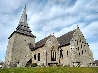
| Description | : | The parish church of St Mary, Kington, dates to the late Norman period. The oldest part of the building is the tower, erected around 1200. Like many church towers in the Welsh border regions, the tower was meant into serve double-duty as a defensive stronghold, and this heritage is evident in the thick walls. The tower was originally detached from the church, but it is now linked to the south aisle by a round-headed Norman arch, presumably moved to this opening from a different place. The nave is early 13th century, while the chancel was added later... Read More |
frequently asked questions (FAQ):
-
Where is St Mary Churchyard?
St Mary Churchyard is located at Kington, Herefordshire Unitary Authority ,Herefordshire ,England.
-
St Mary Churchyard cemetery's updated grave count on graveviews.com?
73 memorials
-
Where are the coordinates of the St Mary Churchyard?
Latitude: 52.2044990
Longitude: -3.0384990
Nearby Cemetories:
1. Kington Cemetery
Kington, Herefordshire Unitary Authority, England
Coordinate: 52.1936780, -3.0209970
2. St Michael and All Angels Churchyard
Knill, Herefordshire Unitary Authority, England
Coordinate: 52.2377070, -3.0396000
3. St. Mary's Churchyard
Almeley, Herefordshire Unitary Authority, England
Coordinate: 52.1576900, -2.9767400
4. St. Mary Magdalene Churchyard
Eardisley, Herefordshire Unitary Authority, England
Coordinate: 52.1366310, -3.0055730
5. St. Michael and All Angels Churchyard
Lingen, Herefordshire Unitary Authority, England
Coordinate: 52.2992480, -2.9317460
6. St Andrew Churchyard
Bredwardine, Herefordshire Unitary Authority, England
Coordinate: 52.0948000, -2.9725000
7. Church of St John the Baptist and St Alkmund
Aymestrey, Herefordshire Unitary Authority, England
Coordinate: 52.2813000, -2.8428000
8. St. Mary the Virgin
Kings Pyon, Herefordshire Unitary Authority, England
Coordinate: 52.1510000, -2.8218000
9. Church of St. Mary
Cusop, Herefordshire Unitary Authority, England
Coordinate: 52.0670000, -3.1100000
10. St Michael and All Angels Churchyard
Kingsland, Herefordshire Unitary Authority, England
Coordinate: 52.2469640, -2.8117000
11. St. Leonard's Churchyard
Blakemere, Herefordshire Unitary Authority, England
Coordinate: 52.0646460, -2.9322980
12. St. Barnabas Churchyard
Brampton Bryan, Herefordshire Unitary Authority, England
Coordinate: 52.3470760, -2.9255360
13. St Michael and All Angels Churchyard
Croft, Herefordshire Unitary Authority, England
Coordinate: 52.2841090, -2.8079510
14. St Mary Churchyard
Bucknell, Shropshire Unitary Authority, England
Coordinate: 52.3592220, -2.9490030
15. St. John's Churchyard
Ivington, Herefordshire Unitary Authority, England
Coordinate: 52.2054890, -2.7700320
16. All Saint's Churchyard
Leominster, Herefordshire Unitary Authority, England
Coordinate: 52.2496430, -2.7703330
17. St. Mary's Churchyard
Credenhill, Herefordshire Unitary Authority, England
Coordinate: 52.0905490, -2.8037610
18. Leominster Moravian Burial Ground
Leominster, Herefordshire Unitary Authority, England
Coordinate: 52.2230890, -2.7394685
19. St Mary Churchyard
Bedstone, Shropshire Unitary Authority, England
Coordinate: 52.3759660, -2.9284570
20. Leominster Cemetery
Leominster, Herefordshire Unitary Authority, England
Coordinate: 52.2144280, -2.7380940
21. Priory Churchyard
Leominster, Herefordshire Unitary Authority, England
Coordinate: 52.2293470, -2.7357830
22. Leominster Nunnery (Defunct)
Leominster, Herefordshire Unitary Authority, England
Coordinate: 52.2294090, -2.7343900
23. Credenhill Military Cemetery
Credenhill, Herefordshire Unitary Authority, England
Coordinate: 52.0869980, -2.7899910
24. St. George's Churchyard
Burrington, Herefordshire Unitary Authority, England
Coordinate: 52.3440700, -2.8200100